
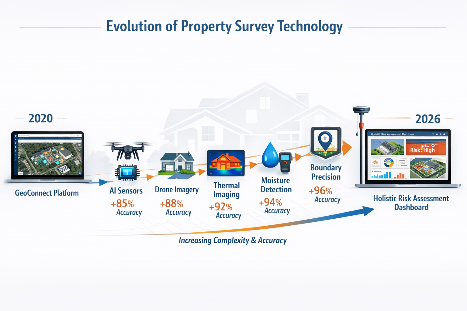
Building surveyors face a critical challenge in 2026: 67% of property transaction delays stem from incomplete upfront assessments, forcing reactive valuations that cost buyers and sellers valuable time and money. Technology for Upfront Property Understanding in Building Surveys: Beyond GeoConnect to Holistic Risk Assessment represents the industry's shift from reactive problem-solving to proactive risk identification, fundamentally changing how professionals gather and analyze property data before committing to valuation methodologies.
The traditional approach—relying on basic boundary tools like GeoConnect and conducting physical inspections only after initial assessments—no longer meets the demands of modern property transactions. As mandatory upfront condition assessments reshape the UK property market, surveyors must adopt comprehensive technology stacks that reveal hidden risks, boundary disputes, and structural concerns before determining the appropriate survey level.

Key Takeaways
- Comprehensive upfront data gathering reduces downstream valuation delays by identifying risks before survey selection
- 2026 ALTA/NSPS standards mandate enhanced boundary precision, encroachment documentation, and easement reporting with dedicated tables
- AI-powered sensors and drone technology provide real-time structural, environmental, and access data that traditional methods miss
- Integrated technology platforms combine boundary mapping, title evidence, and physical condition assessment for holistic risk profiles
- Proactive surveying approaches enable better survey type selection and prevent costly re-assessments during transactions
Understanding the Limitations of Traditional Boundary Tools
GeoConnect and similar boundary identification tools have served the surveying profession well for basic property line verification. These platforms provide essential services—identifying registered boundaries, highlighting potential disputes, and offering preliminary spatial context. However, they represent only the first layer of property understanding, not the complete picture.
What GeoConnect Does Well
GeoConnect excels at:
- ✅ Retrieving Land Registry boundary data quickly
- ✅ Identifying registered title numbers and ownership
- ✅ Highlighting potential boundary overlaps
- ✅ Providing basic mapping context
Where Traditional Tools Fall Short
The critical gap emerges when surveyors rely exclusively on boundary databases without integrating:
- Physical condition data (structural integrity, damp, subsidence)
- Environmental factors (water boundaries, drainage, soil conditions)
- Access rights verification (vehicular access, easements, rights of way)
- Encroachment documentation (building projections, fence lines, overhangs)
- Title evidence reconciliation (recorded vs. actual measurements)
A comprehensive condition survey report requires integrating multiple data sources beyond boundary identification. The 2026 ALTA/NSPS standards reflect this reality, mandating that surveyors provide far more detailed documentation of discrepancies, encroachments, and access rights.[1][2]
The 2026 Standards Revolution: Enhanced Documentation Requirements
The updated 2026 ALTA/NSPS Land Title Survey Standards represent the most significant shift in surveying documentation requirements in over a decade. These changes directly support Technology for Upfront Property Understanding in Building Surveys: Beyond GeoConnect to Holistic Risk Assessment by mandating comprehensive data capture that reveals risks before valuation decisions.
Enhanced Boundary Precision Reporting
Surveyors must now provide Relative Positional Precision (RPP) measurements with clear disclosure of how surveyed properties relate to adjoining parcels. This includes identifying gaps or overlaps that might indicate boundary disputes or encroachment risks.[1]
Why this matters: RPP reporting forces surveyors to quantify uncertainty rather than making assumptions, providing clients with measurable confidence levels in boundary locations.
Dedicated Encroachment Documentation Table 📊
Perhaps the most significant change, surveyors now document potential issues in a dedicated table format rather than generalized notes. Each entry must identify:[6]
| Required Element | Description |
|---|---|
| Observed Evidence | Specific physical feature or condition |
| Location | Precise placement on property |
| Impact Assessment | How it affects property use or value |
| Survey Placement | Where documented on survey drawing |
This structured approach ensures nothing gets buried in narrative descriptions, making risk assessment transparent and actionable.
Comprehensive Discrepancy Documentation
When recorded information conflicts with physical reality, surveyors must now provide detailed explanations including:[2]
- Differences between recorded and measured distances
- Reasons for creating new legal descriptions
- Observations affecting survey conclusions
- Reconciliation of title evidence with physical features
Enhanced Easement and Rights Reporting
Surveys must explicitly state whether easements are:
- ✅ Shown on the survey
- ❌ Cannot be located physically
- 📋 Blanket easements without specific location
- 🔍 Illegible in recorded documents
- ⚠️ Do not affect the surveyed property
Surveyors must also notify title insurers of discovered recorded easements not listed in title materials, closing gaps that previously caused transaction delays.[2]
Vehicular Access Specificity
The 2026 standards require specific identification of vehicular access including driveways, curb cuts, and other observed means of access. This ensures recorded access rights align with real-world use—a critical factor for commercial property valuations.[1]
Water Boundary Measurement Precision
When water features form boundaries, surveys must include:
- 📅 Date measured
- 🌊 Specific feature located (shoreline, high water mark, etc.)
- ⚠️ Acknowledgment that water boundaries change naturally over time[2]
Surveyor Responsibility for Adjoining Deeds
A significant operational change: the 2026 standards eliminated the requirement that title insurers provide copies of adjoining property deeds. This burden now falls on surveyors, potentially creating modest cost and timing impacts but ensuring more complete upfront research.[4][6]
Building a Holistic Technology Stack for Upfront Risk Assessment
Technology for Upfront Property Understanding in Building Surveys: Beyond GeoConnect to Holistic Risk Assessment requires integrating multiple technology platforms that work together to reveal comprehensive property conditions before survey selection. Modern surveyors need tools that address boundary, structural, environmental, and legal dimensions simultaneously.
AI-Powered Smart Building Systems and Sensors
CES 2026 demonstrated how AI-powered sensors are revolutionizing property assessment by providing real-time data on:[5]
- Environmental conditions (humidity, temperature fluctuations, air quality)
- Structural movement (settlement patterns, vibration monitoring)
- Energy efficiency (thermal imaging, insulation performance)
- Water intrusion (moisture detection in walls, floors, roofs)
Companies like Lutron are expanding smart shade automation and humidity sensors that provide continuous environmental monitoring—data that helps surveyors identify potential damp issues or subsidence risks before physical inspection.[5]
Drone Technology for Comprehensive Property Mapping
Drone surveys provide perspectives impossible with ground-based inspection:
- Roof condition assessment without scaffolding or ladders
- Aerial boundary verification showing encroachments from above
- Thermal imaging revealing heat loss and structural anomalies
- 3D modeling for accurate volumetric calculations
When combined with AI analysis, drone footage can identify potential issues that might otherwise require expensive structural surveys to discover.
Virtual and Augmented Reality for Property Assessment
Developers and property managers are using VR and AR to eliminate design guesswork, reducing design errors and accelerating decision-making among stakeholders.[3] For building surveyors, these technologies enable:
- Virtual property walkthroughs for remote preliminary assessment
- AR overlay of boundary lines during site visits
- 3D visualization of proposed alterations for party wall assessments
- Historical comparison showing property changes over time
Integrated Title and Boundary Platforms
Modern platforms go beyond GeoConnect by integrating:
- Land Registry data with real-time updates
- Historical ownership records revealing past disputes
- Planning permission history showing approved alterations
- Environmental databases flagging flood zones, contamination, mining subsidence
- Utility mapping showing service locations and easements
Mobile Data Collection and Cloud Integration
Surveyors equipped with tablets and mobile apps can:
- Capture georeferenced photos linked to specific property features
- Record voice notes transcribed automatically by AI
- Access historical survey data in the field
- Update clients in real-time with preliminary findings
- Generate preliminary reports before leaving the site
This approach dramatically reduces the time between inspection and report delivery, supporting faster transaction timelines.
Implementing Proactive Survey Selection Through Technology
The ultimate goal of Technology for Upfront Property Understanding in Building Surveys: Beyond GeoConnect to Holistic Risk Assessment is better decision-making about which survey type clients actually need. By gathering comprehensive data upfront, surveyors can confidently recommend the appropriate assessment level.
The Survey Selection Decision Tree
Understanding what survey you need becomes clearer with comprehensive upfront data:
When upfront technology reveals:
- ✅ Clean boundaries, no structural concerns, modern construction → Level 2 survey may suffice
- ⚠️ Minor boundary questions, older property, some maintenance issues → Consider Level 2 vs Level 3 comparison
- 🚨 Encroachments, structural movement, complex boundaries, non-standard construction → Level 3 survey essential
Reducing Unnecessary Escalations
Traditional reactive approaches often lead to survey escalation mid-transaction:
- Client orders basic valuation
- Surveyor discovers unexpected issues during inspection
- Recommends upgrading to more comprehensive survey
- Transaction delayed while additional assessment conducted
- Costs increase, relationships strain
Proactive technology-driven approach:
- Comprehensive data gathered before survey selection
- Appropriate survey level recommended from the start
- Single inspection captures all necessary information
- Transaction proceeds smoothly
- Client satisfaction and professional reputation enhanced
Case Study: Preventing Boundary Dispute Delays
Consider a typical Victorian terrace property transaction:
Traditional approach: Basic boundary check shows no obvious issues. Level 2 survey ordered. During inspection, surveyor notices rear extension appears to encroach on neighboring property. Survey paused. Boundary dispute investigation required. Transaction delayed 6-8 weeks.
Technology-enabled approach: Upfront drone survey reveals rear extension extends 30cm beyond recorded boundary. Title evidence review shows no recorded easement. Neighboring property deeds obtained (per 2026 standards). Issue identified before survey selection. Client advised to resolve boundary question before proceeding, or accept risk with appropriate survey level. Transaction proceeds with full knowledge, no surprises.

Practical Implementation: Building Your Technology Toolkit
For surveying practices looking to adopt Technology for Upfront Property Understanding in Building Surveys: Beyond GeoConnect to Holistic Risk Assessment, implementation requires strategic investment and training.
Essential Technology Investments
Tier 1: Foundation (£5,000-£15,000)
- Professional drone with thermal imaging capability
- Tablet with survey-specific mobile apps
- Cloud storage and data management system
- Basic AI-powered photo analysis tools
Tier 2: Enhanced Capability (£15,000-£40,000)
- Advanced boundary and title integration platform
- VR/AR visualization software
- AI-powered structural analysis tools
- Comprehensive environmental database subscriptions
Tier 3: Market Leadership (£40,000+)
- Custom integrated platform development
- Advanced sensor networks for continuous monitoring
- Machine learning models trained on practice-specific data
- Automated report generation with AI assistance
Training and Competency Development
Technology adoption fails without proper training. Surveyors need:
- Technical proficiency in operating drones, sensors, and software
- Data interpretation skills for AI-generated insights
- Regulatory knowledge of 2026 ALTA/NSPS standards (for US work) and UK equivalents
- Client communication explaining technology benefits and limitations
Workflow Integration
Successful practices integrate technology into every stage:
Pre-instruction:
- Automated data gathering on potential properties
- Risk flagging before client contact
- Accurate quote generation based on complexity
Instruction:
- Clear explanation of technology benefits
- Transparent pricing for enhanced assessment
- Setting realistic timelines
Fieldwork:
- Systematic data collection using mobile tools
- Real-time cloud backup
- Preliminary risk identification
Reporting:
- Automated report generation with manual review
- Visual presentation of complex data
- Clear risk categorization
Post-delivery:
- Client feedback collection
- Data archiving for future reference
- Continuous improvement analysis
Addressing Common Concerns and Limitations
Data Privacy and Security
Comprehensive data collection raises legitimate privacy concerns. Surveyors must:
- Comply with GDPR and data protection regulations
- Secure cloud storage with encryption
- Obtain appropriate permissions for drone photography
- Maintain client confidentiality
Technology Reliability
No technology is perfect. Best practices include:
- Redundancy: Multiple data sources confirming findings
- Human oversight: Professional judgment reviewing AI outputs
- Calibration: Regular equipment testing and maintenance
- Backup systems: Alternative methods when technology fails
Cost-Benefit Analysis
Clients may question technology costs. The value proposition:
- Time savings: Faster assessments reduce transaction delays
- Risk reduction: Identifying issues early prevents costly surprises
- Better decisions: Appropriate survey selection from the start
- Professional credibility: Demonstrating modern, thorough approach
Regulatory Compliance
As standards evolve, surveyors must ensure technology supports compliance:
- 2026 ALTA/NSPS requirements for US-related work
- RICS standards for UK practice
- Local authority requirements for specific survey types
- Insurance and liability considerations
The Future of Upfront Property Understanding
Technology for Upfront Property Understanding in Building Surveys: Beyond GeoConnect to Holistic Risk Assessment represents the present reality, not a distant future. The trajectory points toward even more integrated systems:
Emerging Technologies
Blockchain for Title Evidence
Immutable records of ownership, easements, and rights could eliminate title search delays and discrepancies.
Machine Learning for Risk Prediction
AI models trained on millions of surveys could predict likely issues based on property characteristics, location, and age.
IoT Integration
Properties with existing smart systems could share historical environmental and structural data directly with surveyors.
Automated Valuation Models (AVMs) Enhanced by Physical Data
Combining market data with real-time structural condition assessment for more accurate valuations.
Regulatory Evolution
Expect continued tightening of documentation requirements, with technology enabling rather than burdening compliance. The 2026 standards represent a step toward comprehensive disclosure, not the final destination.
Professional Differentiation
Surveyors who master comprehensive upfront assessment will command premium fees and client loyalty. Those relying on traditional reactive methods will face increasing competitive pressure.
Conclusion
Technology for Upfront Property Understanding in Building Surveys: Beyond GeoConnect to Holistic Risk Assessment transforms surveying from reactive problem identification to proactive risk management. The 2026 ALTA/NSPS standards mandate the comprehensive documentation that technology makes possible, while client expectations demand the speed and certainty that integrated platforms deliver.
Building surveyors can no longer rely on boundary tools alone. Success in 2026 and beyond requires integrating AI-powered sensors, drone technology, VR/AR visualization, comprehensive title platforms, and mobile data collection into cohesive workflows that reveal property conditions before committing to survey methodologies.
Actionable Next Steps
- Audit your current technology stack against the capabilities outlined in this article
- Prioritize investments based on your practice's typical property types and client needs
- Develop training programs ensuring all surveyors can effectively use new tools
- Update your service offerings to highlight comprehensive upfront assessment capabilities
- Review compliance with 2026 standards and integrate required documentation into workflows
- Engage with clients about the benefits of technology-enabled surveying
- Monitor emerging technologies and plan for continuous capability enhancement
The opportunity is clear: surveyors who embrace comprehensive upfront property understanding will reduce transaction delays, enhance client satisfaction, and build competitive advantages in an increasingly sophisticated market. Those who wait risk becoming irrelevant as technology-enabled competitors capture market share with superior service delivery.
For guidance on implementing these approaches in your practice, explore our resources on building surveys in London and comparing different survey types to understand how technology integration enhances traditional surveying excellence.
References
[1] New 2026 Alta Nsps Survey Standards What Developers And Counsel Should Know – https://hallrender.com/2026/02/23/new-2026-alta-nsps-survey-standards-what-developers-and-counsel-should-know/
[2] 2026 Alta Survey Standards Updates 7956483 – https://www.jdsupra.com/legalnews/2026-alta-survey-standards-updates-7956483/
[3] Real Estate Technology In 2026 Tools To Drive Growth And Efficiency – https://www.bradymartz.com/real-estate-technology-in-2026-tools-to-drive-growth-and-efficiency/
[4] 2026 Alta Nsps Survey Standards Update Key Takeaways For Commercial Real Estate – https://www.taftlaw.com/news-events/law-bulletins/2026-alta-nsps-survey-standards-update-key-takeaways-for-commercial-real-estate/
[5] Ces 2026 Smart Home Trends Real Estate Agents Should Be Paying Attention To – https://www.nar.realtor/magazine/real-estate-news/technology/ces-2026-smart-home-trends-real-estate-agents-should-be-paying-attention-to
[6] Five Key Updates 2026 Altansps Land Title Survey Standards – https://westwoodps.com/recent-blog-posts/five-key-updates-2026-altansps-land-title-survey-standards