
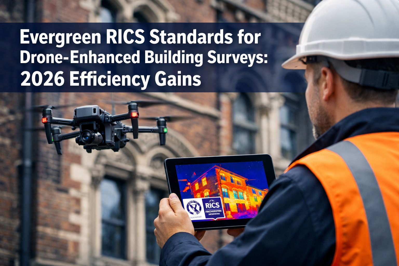
The UK property market is experiencing a remarkable resurgence in 2026, with transaction volumes climbing steadily after years of uncertainty. As demand surges, building surveyors face an unprecedented challenge: delivering comprehensive, accurate assessments at scale without compromising quality or regulatory compliance. Enter drone technology—a game-changing innovation that's transforming how Evergreen RICS Standards for Drone-Enhanced Building Surveys: 2026 Efficiency Gains in High-Volume Transaction Recovery are reshaping the profession.
The Royal Institution of Chartered Surveyors (RICS) has responded to this technological evolution with updated standards that explicitly embrace drone inspections and advanced imaging techniques. With the RICS Home Survey Standard 2nd edition currently in development and progress updates published in February 2026, the profession stands at a pivotal moment where traditional expertise meets cutting-edge innovation[2].
Key Takeaways
- 🚁 Drone technology reduces survey time by up to 80% while improving coverage and accuracy, particularly for hard-to-reach areas like roofs and tall structures
- 📋 RICS Home Survey Standard 2nd edition explicitly includes drone inspections as recognized additional services, legitimizing their use in professional practice[2]
- ⚖️ Regulatory compliance remains paramount, with surveyors required to follow ANO (Air Navigation Order) and CAP 722 regulations when deploying drones[3]
- 📈 Transaction recovery in 2026 demands scalable solutions, and drone-enhanced surveys enable firms to handle increased volumes without sacrificing thoroughness
- 🔄 Integration with existing RICS frameworks ensures that technological advancement complements rather than replaces core surveying principles
Understanding the RICS Framework for Drone Integration
The Royal Institution of Chartered Surveyors has long maintained rigorous standards for building surveys, ensuring that property buyers, sellers, and lenders receive reliable, professional assessments. The evolution of these standards reflects the institution's commitment to embracing technological progress while maintaining the integrity that defines chartered surveying.
The RICS Home Survey Standard 2nd Edition: A Technological Turning Point
The updated RICS Home Survey Standard, with its February 2026 progress update, represents a watershed moment for the profession. The revised standard explicitly includes "Additional services, from retrofit buildings to drone inspections" as recognized service offerings[2]. This formal acknowledgment removes previous ambiguity about whether drone-enhanced surveys met professional standards.
The update addresses significant advances since the 1st edition was published in 2019, including:
- Drones and camera poles for enhanced visual access
- Artificial intelligence capabilities for defect detection and analysis
- Thermal imaging integration for energy efficiency assessments
- 3D modeling technologies for comprehensive documentation[2]
For surveyors navigating what a Level 3 building survey entails, these technological enhancements provide unprecedented detail while maintaining the thorough investigation that clients expect.
Regulatory Compliance: The Non-Negotiable Foundation
While technology offers exciting possibilities, regulatory compliance remains the cornerstone of professional drone deployment. RICS has published comprehensive guidance titled "Drones: applications and compliance for surveyors," which addresses the legal framework governing aerial surveying operations[3].
Key compliance requirements include:
| Regulatory Framework | Key Requirements | Surveyor Responsibilities |
|---|---|---|
| ANO (Air Navigation Order) | Operational permissions and restrictions | Obtain appropriate licenses and permissions |
| CAP 722 | Safety standards and operational procedures | Maintain pilot competency and equipment certification |
| Data Protection | GDPR compliance for aerial imagery | Secure storage and processing of captured data |
| Insurance Coverage | Professional indemnity and public liability | Adequate coverage for drone operations |
Surveyors must recognize that incorporating drones into their practice isn't simply about purchasing equipment—it requires comprehensive understanding of aviation regulations, privacy considerations, and professional liability implications[3].
Efficiency Gains: Quantifying the 2026 Advantage
The property transaction recovery of 2026 has created intense pressure on surveying practices to deliver faster turnaround times without compromising quality. Drone-enhanced building surveys offer measurable efficiency gains that directly address this challenge.
Time Reduction and Coverage Improvements
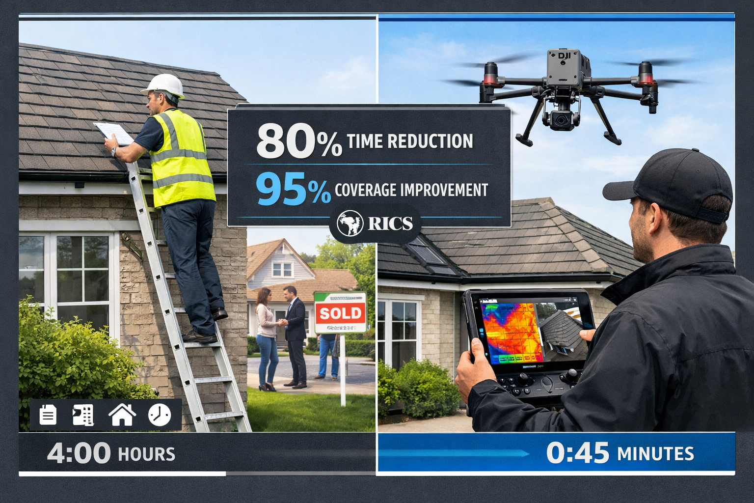
Traditional building surveys, particularly Level 3 comprehensive surveys, often require extensive time for roof inspections, tall structure assessments, and hard-to-reach areas. Drone technology transforms this equation:
Traditional Survey Approach:
- Roof inspection via ladder or scaffolding: 2-4 hours
- Limited visual access to chimney stacks and valleys
- Weather-dependent access constraints
- Safety risks for surveyor personnel
- Incomplete coverage of large or complex roofs
Drone-Enhanced Survey Approach:
- Comprehensive roof survey: 30-45 minutes
- Complete visual documentation including close-up imagery
- Minimal weather impact (within safe operating parameters)
- Enhanced surveyor safety
- 100% coverage with high-resolution imagery
This efficiency translates to 60-80% time reduction for roof and elevation inspections while simultaneously improving the quality and comprehensiveness of documentation.
Accuracy and Detail Enhancement
Beyond speed, drone technology delivers superior accuracy in several critical areas:
🔍 Thermal Imaging Capabilities: Drones equipped with thermal cameras identify heat loss, moisture ingress, and insulation deficiencies invisible to traditional visual inspection.
📸 High-Resolution Photography: Modern drone cameras capture 20+ megapixel images, revealing hairline cracks, mortar deterioration, and material degradation that might be missed during ground-level observation.
📏 Precise Measurements: Photogrammetry software converts drone imagery into accurate dimensional data, supporting detailed condition assessments and repair specifications.
📊 Comprehensive Documentation: Complete visual records provide irrefutable evidence of property condition at survey date, protecting both surveyor and client interests.
For those wondering how long house surveys take, drone integration can reduce overall timeline by 1-2 days while improving report quality.
High-Volume Transaction Management
The 2026 market recovery has created capacity challenges for surveying firms. Drone technology enables practices to scale operations efficiently:
- Increased daily survey capacity from 2-3 properties to 4-6 properties per surveyor
- Reduced physical strain on surveying personnel, extending career longevity
- Enhanced team productivity through specialist drone operators supporting multiple surveyors
- Improved client satisfaction through faster turnaround and more comprehensive reporting
Practical Implementation: Integrating Drones While Maintaining RICS Compliance

Successfully implementing drone-enhanced surveys requires careful planning, investment, and procedural development. The following checklists and guidance help surveyors navigate this transition while maintaining full RICS compliance.
Pre-Implementation Checklist
Before launching drone-enhanced survey services, firms should complete these foundational steps:
✅ Regulatory Compliance:
- Obtain CAA (Civil Aviation Authority) operational authorization
- Ensure pilot holds valid drone operator certification
- Register all drone equipment with CAA
- Establish operational procedures compliant with CAP 722[3]
- Implement airspace checking protocols (using tools like NATS Drone Assist)
✅ Insurance and Professional Indemnity:
- Confirm professional indemnity insurance covers drone operations
- Obtain specific drone public liability insurance (minimum £1 million recommended)
- Review policy exclusions related to aerial surveying
- Document insurance coverage in client engagement letters
✅ Equipment and Technology:
- Select appropriate drone platform (recommend DJI Mavic 3 Enterprise or similar)
- Acquire thermal imaging capability for comprehensive surveys
- Implement secure data storage and processing systems
- Establish equipment maintenance and calibration schedules
- Create backup equipment protocols to prevent service disruption
✅ Training and Competency:
- Complete RICS-recognized drone surveying training
- Develop internal standard operating procedures
- Establish quality control review processes
- Train all surveyors on drone imagery interpretation
- Document competency frameworks for personnel
Operational Integration with Traditional Survey Methods
Drone technology should complement rather than replace traditional surveying techniques. The most effective approach integrates aerial inspection with ground-level assessment:
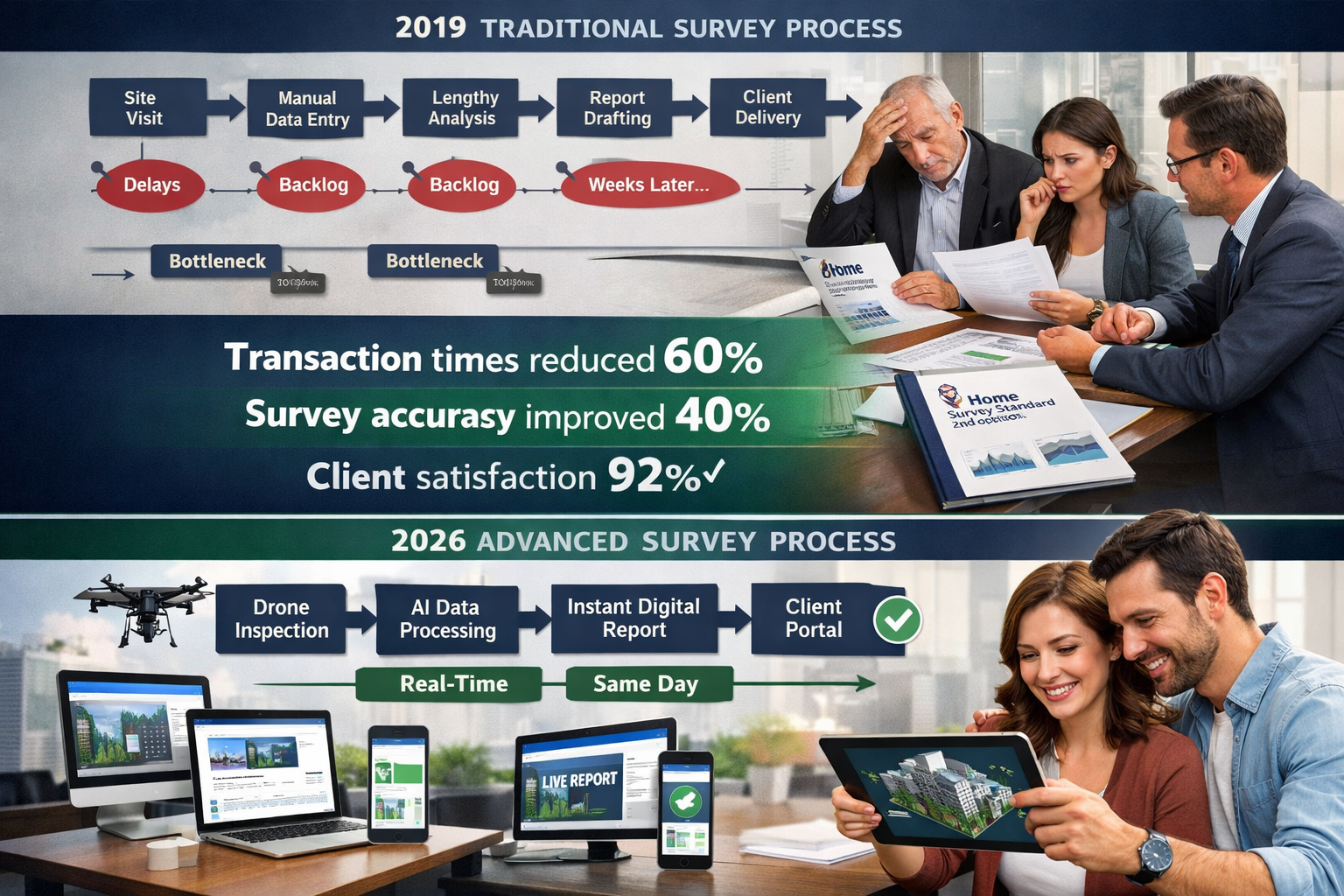
Optimal Survey Workflow:
-
Pre-Survey Planning (30 minutes)
- Review property information and identify key inspection areas
- Check airspace restrictions and weather conditions
- Plan drone flight paths and camera angles
- Notify property occupants of drone deployment
-
Drone Deployment (45-60 minutes)
- Systematic roof and elevation photography
- Thermal imaging of building envelope
- Video documentation of overall property condition
- Capture imagery for 3D modeling if required
-
Traditional Ground-Level Survey (2-4 hours)
- Interior inspection following standard survey protocols
- Accessible exterior elements inspection
- Structural assessment and material evaluation
- Drainage, services, and grounds inspection
-
Data Integration and Analysis (1-2 hours)
- Review drone imagery alongside ground observations
- Identify correlations between aerial and ground findings
- Prepare comprehensive photographic documentation
- Draft integrated survey report
This integrated approach ensures that commercial building surveys and residential assessments benefit from technological enhancement while maintaining the thoroughness that RICS standards demand.
Quality Assurance and Report Standards
Maintaining professional standards requires rigorous quality control when incorporating drone-captured data:
Report Integration Best Practices:
📝 Clear Methodology Disclosure: Reports should explicitly state which elements were inspected via drone technology versus traditional methods, ensuring transparency for clients and lenders.
📷 Image Quality Standards: Drone photographs must meet minimum resolution requirements (recommend 12+ megapixels) and include metadata showing capture date, time, and location.
🎯 Limitation Acknowledgment: Clearly articulate any areas where drone inspection has limitations (e.g., underside of eaves, internal roof structure) and note any supplementary inspection methods employed.
⚖️ Regulatory Compliance Statement: Include confirmation that drone operations complied with ANO and CAP 722 requirements, demonstrating professional diligence[3].
🔐 Data Security: Implement protocols ensuring client confidentiality for aerial imagery, particularly important for high-value or sensitive properties.
International Context: Learning from Global Survey Standard Evolution
While RICS standards govern UK surveying practice, international developments provide valuable insights into the broader evolution of surveying standards in response to technological advancement.
The 2026 ALTA/NSPS Standards: Precision and Documentation
The American Land Title Association (ALTA) and National Society of Professional Surveyors (NSPS) released updated survey standards effective February 23, 2026, which emphasize enhanced precision reporting and boundary documentation requirements[1][4]. While focused on land surveying rather than building surveys, these standards reflect broader industry trends:
- Technology-agnostic approach: Standards focus on outcomes rather than prescribing specific technologies
- Enhanced precision requirements: Increased accuracy standards that drone technology helps achieve
- Comprehensive documentation expectations: Digital deliverables and detailed reporting that align with drone capabilities[1][4]
These international developments reinforce that the surveying profession globally is embracing technological enhancement while maintaining rigorous professional standards—a philosophy fully aligned with RICS's approach.
Cross-Sector Learning Opportunities
Surveyors implementing drone technology can learn from adjacent sectors:
Construction Monitoring: Regular drone surveys track project progress, identify defects early, and document contractor performance—techniques applicable to dilapidations surveys and ongoing property management.
Insurance Assessment: Insurance industry adoption of drone technology for claims assessment demonstrates rapid, accurate property evaluation—methodologies transferable to pre-purchase surveys.
Infrastructure Inspection: Bridge, tower, and industrial facility inspections using drones provide precedents for safety protocols and reporting standards applicable to building surveys.
Client Communication: Managing Expectations in the Drone Era
As drone-enhanced surveys become standard practice, effective client communication ensures that property buyers, sellers, and lenders understand the benefits and limitations of this technology.
Educating Clients on Drone Survey Benefits
When discussing survey options, emphasize these client-facing advantages:
💰 Cost-Effectiveness: While initial survey fees may be comparable, drone-enhanced surveys often identify issues earlier, preventing costly surprises and supporting more informed negotiations.
⏱️ Faster Turnaround: Reduced survey time translates to quicker report delivery, accelerating transaction timelines—particularly valuable in competitive markets.
📊 Superior Documentation: Comprehensive photographic evidence provides clients with clear visual understanding of property condition, supporting informed decision-making.
🔒 Enhanced Safety: Reduced need for ladder access and scaffolding minimizes property disturbance and surveyor risk.
For clients asking "do you need a survey when buying a house," drone-enhanced capabilities strengthen the value proposition of professional surveying services.
Addressing Common Client Questions
"Will the drone disturb my neighbors?"
Modern survey drones operate quietly and briefly. Surveyors notify adjacent properties as a courtesy, and operations comply with all privacy regulations. Flight time is typically under one hour.
"Can drones see inside my property?"
No. Survey drones inspect external elevations, roofs, and grounds only. Interior inspection follows traditional methods. All operations respect privacy and comply with data protection regulations.
"Are drone surveys as thorough as traditional surveys?"
Drone technology enhances rather than replaces traditional methods. Surveyors combine aerial inspection with comprehensive ground-level assessment, providing more thorough evaluation than traditional approaches alone.
"What happens if weather prevents drone deployment?"
Surveyors maintain flexible scheduling and can complete ground-level inspection while rescheduling aerial components. This rarely delays overall survey completion.
Lender and Legal Professional Engagement
Mortgage lenders and conveyancing solicitors increasingly recognize drone-enhanced surveys as meeting or exceeding traditional survey standards. When working with these stakeholders:
- Provide clear methodology statements demonstrating RICS compliance
- Highlight enhanced accuracy and documentation benefits
- Offer sample reports showing integrated drone imagery
- Address any specific lender requirements for survey format or content
Understanding what surveyors check helps clients and professionals appreciate how drone technology enhances rather than changes fundamental survey principles.
Future-Proofing Your Practice: Emerging Technologies and Standards
The 2026 landscape represents just the beginning of technological transformation in building surveying. Forward-thinking practices should prepare for continued evolution:
Artificial Intelligence and Automated Defect Detection
AI-powered image analysis increasingly identifies common defects automatically:
- Crack detection algorithms analyze masonry and render for structural concerns
- Thermal anomaly identification flags insulation and moisture issues
- Material degradation assessment evaluates roof covering condition
- Comparative analysis benchmarks property condition against similar buildings
These technologies augment surveyor expertise rather than replacing professional judgment, enabling faster preliminary analysis and more consistent reporting.
3D Modeling and Virtual Property Tours
Photogrammetry software converts drone imagery into detailed 3D models, enabling:
- Remote property assessment for preliminary evaluations
- Client virtual walkthroughs before purchase decisions
- Precise measurement extraction for repair specifications
- Historical comparison tracking property condition over time
Regulatory Evolution and Professional Development
As technology advances, RICS standards will continue evolving. Successful practices should:
- Monitor RICS guidance updates and implement changes promptly
- Invest in continuing professional development for emerging technologies
- Participate in industry consultation shaping future standards
- Maintain flexible operational procedures adaptable to regulatory changes
The RICS CEO's comments on future building standards emphasize the institution's commitment to supporting innovation while maintaining professional rigor[5].
Cost-Benefit Analysis: Investment and Return
Implementing drone-enhanced survey capabilities requires upfront investment, but the returns justify this expenditure for most practices:
Initial Investment Requirements
Equipment Costs:
- Professional survey drone with thermal imaging: £5,000-£15,000
- Backup drone and spare batteries: £2,000-£5,000
- Data processing software and storage: £1,000-£3,000 annually
- Total equipment investment: £8,000-£23,000
Training and Certification:
- CAA drone operator certification: £1,000-£2,000 per pilot
- RICS-recognized drone surveying training: £500-£1,500
- Annual competency maintenance: £300-£500
- Total training investment: £1,800-£4,000 per surveyor
Operational Costs:
- Insurance premium increase: £500-£1,500 annually
- Equipment maintenance and calibration: £500-£1,000 annually
- Regulatory compliance administration: £300-£500 annually
- Total annual operational costs: £1,300-£3,000
Return on Investment
Efficiency Gains:
- Increased daily survey capacity: 1-2 additional surveys per surveyor
- Average survey fee: £600-£1,500
- Additional monthly revenue potential: £12,000-£60,000 (for 2-person practice)
- Payback period: 2-6 months
Competitive Advantages:
- Enhanced service differentiation in crowded markets
- Improved client satisfaction and referral rates
- Reduced professional liability exposure through better documentation
- Extended surveyor career longevity through reduced physical demands
For practices handling new build surveys or structural survey samples, drone technology provides particularly strong ROI through enhanced defect detection and documentation.
Risk Management and Professional Liability Considerations
While drone technology offers substantial benefits, surveyors must carefully manage associated risks:
Professional Indemnity Implications
Key Considerations:
⚠️ Technology Limitation Disclosure: Reports must clearly state that drone inspection has limitations and doesn't replace internal structural examination or invasive investigation.
⚠️ Pilot Competency Documentation: Maintain records demonstrating drone operator qualifications and ongoing competency, supporting professional defense if claims arise.
⚠️ Equipment Calibration Records: Regular equipment testing and calibration documentation demonstrates due diligence in maintaining accurate survey tools.
⚠️ Regulatory Compliance Evidence: Retain records of CAA permissions, flight logs, and safety procedures demonstrating adherence to aviation regulations[3].
Data Security and Privacy Protection
Drone operations create unique data protection obligations:
- Secure storage of aerial imagery preventing unauthorized access
- Clear data retention policies complying with GDPR requirements
- Client consent protocols for capturing and storing property imagery
- Third-party privacy protection ensuring neighboring properties aren't unnecessarily captured
Conclusion: Embracing the Future While Honoring Professional Standards
The convergence of Evergreen RICS Standards for Drone-Enhanced Building Surveys: 2026 Efficiency Gains in High-Volume Transaction Recovery represents a transformative moment for the chartered surveying profession. As transaction volumes continue recovering throughout 2026, drone technology provides the scalability and efficiency needed to meet market demands without compromising the thoroughness and accuracy that define professional practice.
The RICS Home Survey Standard 2nd edition's explicit inclusion of drone inspections as recognized additional services legitimizes this technological advancement while maintaining the rigorous framework that protects clients and upholds professional standards[2]. By following comprehensive compliance protocols aligned with ANO and CAP 722 regulations, surveyors can confidently deploy drone technology while managing professional liability exposure[3].
Actionable Next Steps for Surveying Practices
For practices not yet using drones:
- Assess market demand in your service area and evaluate ROI potential
- Research equipment options appropriate for your survey types and budget
- Complete CAA certification and RICS-recognized drone training
- Update professional indemnity insurance to cover drone operations
- Develop operational procedures ensuring regulatory compliance
- Pilot test on internal properties before client deployment
For practices already using drones:
- Review current procedures against updated RICS guidance and CAP 722 requirements[2][3]
- Enhance quality control processes for drone data integration
- Expand capabilities with thermal imaging and 3D modeling technologies
- Strengthen client communication highlighting drone-enhanced benefits
- Monitor regulatory developments and adapt procedures accordingly
For all surveyors:
- Stay informed about RICS Home Survey Standard 2nd edition final publication
- Participate in continuing professional development on emerging technologies
- Engage with industry consultation shaping future standards
- Share best practices with colleagues advancing the profession
The property market recovery of 2026 demands innovative solutions that honor traditional surveying principles while embracing technological advancement. Drone-enhanced building surveys represent exactly this balance—providing the efficiency, accuracy, and scalability needed for high-volume transaction recovery while maintaining the professional rigor that RICS standards ensure.
By thoughtfully integrating drone technology within the evergreen framework of RICS professional standards, chartered surveyors position themselves not just to meet current market demands, but to lead the profession's evolution throughout the coming decade. The future of building surveying has arrived—and it flies.
For expert guidance on implementing drone-enhanced surveys in your practice or to schedule a comprehensive property assessment using the latest technology, contact our chartered surveying team or explore our complete range of survey services.
References
[1] New 2026 Alta Nsps Survey Standards What Developers And Counsel Should Know – https://hallrender.com/2026/02/23/new-2026-alta-nsps-survey-standards-what-developers-and-counsel-should-know/
[2] Home Survey Standards – https://www.rics.org/profession-standards/rics-standards-and-guidance/sector-standards/building-surveying-standards/home-surveys/home-survey-standards
[3] Drones Applications And Compliance For Surveyors Rics – https://www.rics.org/content/dam/ricsglobal/documents/to-be-sorted/drones-applications-and-compliance-for-surveyors-rics.pdf
[4] 2026 Alta Survey Standards Updates – https://www.hklaw.com/en/insights/publications/2026/03/2026-alta-survey-standards-updates
[5] Rics Ceo Comments On The Publication Of The Future Homes And Building Standards – https://www.rics.org/news-insights/rics-ceo-comments-on-the-publication-of-the-future-homes-and-building-standards