
The property surveying profession stands at a pivotal intersection in 2026. Imagine overlaying decades of property records, current zoning regulations, underground utility networks, and real-time topographic data—all on a single interactive map that updates instantly and can be shared with clients, planners, and contractors simultaneously. This isn't science fiction; it's the reality that GIS Integration for Property Surveyors: Streamlining Boundary Analysis and Land Use Planning in 2026 has made possible. Geographic Information Systems (GIS) have evolved from specialized tools into essential platforms that fundamentally transform how surveyors analyze boundaries, assess properties, and contribute to land use planning decisions.
As the surveying industry accelerates its digital transformation amid workforce shortages and increasingly complex client demands, GIS integration has emerged as one of the most vital innovations in modern surveying[1]. Property surveyors who master GIS workflows can deliver visualization-ready data that positions them as essential collaborative partners rather than simple measurement vendors—a crucial competitive advantage in today's infrastructure-driven market.
Key Takeaways
- 🗺️ Multi-Layer Data Integration: GIS enables surveyors to overlay zoning information, property boundaries, utility locations, and topographic data on single interactive maps, dramatically streamlining boundary analysis workflows
- 🤖 AI-Powered Automation: AI-driven GIS systems in 2026 automatically detect land-use changes, predict urban expansion, and identify infrastructure vulnerabilities, significantly enhancing planning accuracy and speed
- 📊 Visualization as Competitive Advantage: Delivering survey data optimized for 3D visualization and BIM integration transforms surveyors from vendors into essential collaborative partners
- ☁️ Real-Time Collaboration: Cloud-based GIS platforms enable instant data sharing and decision-making across project teams, meeting client expectations for seamless technology integration
- 🏗️ Infrastructure Boom Applications: With aging infrastructure and urban expansion driving demand, GIS-equipped surveyors are uniquely positioned to support asset lifecycle management and development projects
Understanding GIS Integration in Modern Property Surveying

Geographic Information Systems represent far more than digital mapping software. At their core, GIS platforms function as sophisticated spatial databases that capture, store, analyze, and visualize geographic data. For property surveyors, this means transforming traditional measurement data into dynamic, queryable information layers that reveal relationships and patterns invisible in conventional survey deliverables.
What Makes GIS Different from Traditional Survey Tools
Traditional surveying tools excel at precise measurement and documentation. Total stations, GPS receivers, and laser scanners capture accurate spatial coordinates and distances. However, these tools typically produce isolated datasets—a boundary survey here, an elevation map there, utility locations in a separate file.
GIS integration changes this paradigm entirely. Instead of separate documents, all survey data becomes interconnected layers within a spatial database. A single property can be understood through multiple simultaneous perspectives: legal boundaries, physical features, zoning restrictions, utility easements, flood zones, soil types, and historical ownership—all queryable and visualizable together.
This integration capability has become one of the most vital innovations in modern surveying, with industries increasingly recognizing and integrating GIS into surveying processes[1]. The shift represents a fundamental change in how spatial data is managed across the profession.
Core Components of GIS Systems for Surveyors
Modern GIS platforms for property surveying typically include several essential components:
Data Capture and Input Tools 📍
- Direct integration with survey equipment (total stations, GPS, drones)
- Import capabilities for CAD files, point clouds, and imagery
- Georeferencing tools to align historical maps and documents
- Mobile data collection apps for field verification
Spatial Database Management
- Centralized storage for all geographic data
- Version control and data history tracking
- Multi-user access with permission controls
- Automated backup and data integrity checks
Analysis and Processing Functions
- Overlay analysis to identify spatial relationships
- Buffer and proximity calculations
- Terrain modeling and slope analysis
- Statistical analysis of spatial patterns
Visualization and Output
- Interactive map creation and customization
- 3D modeling and visualization
- Report generation with embedded maps
- Web-based map sharing and collaboration
Understanding these components helps surveyors select appropriate GIS platforms and design efficient workflows. For professionals looking to enhance their surveying capabilities, exploring comprehensive surveying services provides context for how GIS integration fits within broader professional offerings.
How GIS Integration Streamlines Boundary Analysis
Boundary analysis represents one of the most critical—and traditionally time-consuming—aspects of property surveying. Determining precise property lines requires reviewing historical deeds, reconciling conflicting descriptions, identifying monuments, and resolving discrepancies between legal descriptions and physical evidence. GIS integration transforms this complex process into a systematic, data-driven workflow.
Multi-Layer Data Overlay for Comprehensive Boundary Assessment
The fundamental advantage of GIS Integration for Property Surveyors: Streamlining Boundary Analysis and Land Use Planning in 2026 lies in the ability to overlay multiple datasets on a single map. Surveyors can now visualize:
- Legal boundary descriptions from deeds and plats
- Physical survey monuments and their conditions
- Adjacent property boundaries and potential conflicts
- Easements and rights-of-way affecting property use
- Zoning boundaries and setback requirements
- Utility locations and easement corridors
- Topographic features that may affect boundary placement
This comprehensive overlay capability enables surveyors to identify potential boundary issues before fieldwork begins, significantly reducing time spent on-site and minimizing the risk of costly resurveys[1].
Consider a typical boundary dispute scenario. Traditionally, a surveyor would need to:
- Review paper deeds and plats at the county recorder's office
- Create separate sketches of each property description
- Physically overlay transparent sheets to identify conflicts
- Return to the field multiple times to verify findings
- Produce final drawings manually or in separate CAD files
With GIS integration, this process becomes:
- Query the centralized GIS database for all relevant parcels
- Automatically overlay all boundary layers with color-coding
- Run spatial analysis to identify overlaps, gaps, or conflicts
- Generate field verification lists with GPS coordinates
- Update the database in real-time during fieldwork
- Produce client-ready visualizations instantly
Real-World Application: Resolving Complex Boundary Conflicts
A practical example illustrates the power of GIS-integrated boundary analysis. A surveyor receives a request to establish boundaries for a rural property with conflicting deed descriptions dating back to the 1800s. The property includes:
- Multiple ownership transfers with varying descriptions
- References to long-lost physical monuments
- Overlapping claims with three adjacent properties
- A utility easement of uncertain location
- Portions within a floodplain requiring setback verification
Using GIS integration, the surveyor:
Step 1: Data Assembly 🗂️
Imports all historical deed descriptions into the GIS database, georeferencing each description based on available coordinate information and bearing/distance calls.
Step 2: Overlay Analysis
Creates separate layers for each deed description, adjacent property boundaries (obtained from county GIS data), utility easements, and floodplain boundaries. The overlay immediately reveals three areas of conflicting boundary descriptions.
Step 3: Historical Research Integration
Adds a layer of historical aerial photography from various decades, allowing visual identification of fence lines, roads, and structures that may indicate historic boundary acceptance.
Step 4: Field Verification Planning
Generates a targeted field verification list showing only the specific areas requiring physical monument searches, reducing field time by approximately 60% compared to traditional methods.
Step 5: Client Visualization
Creates an interactive web map that clients can access from any device, showing the proposed boundary resolution with color-coded confidence levels and explanatory notes at each decision point.
This workflow demonstrates how GIS integration enables better data management by organizing and centralizing vast amounts of geospatial data, enhanced analysis by identifying patterns and trends in land use, and improved decision-making through easy-to-understand visualizations[1].
For surveyors specializing in boundary disputes, understanding the fundamentals of boundary surveys provides essential context for applying GIS tools effectively.
Automated Conflict Detection and Quality Control
One of the most powerful features of GIS integration for boundary analysis is automated conflict detection. Modern GIS platforms can be configured to automatically flag:
- Gap and overlap errors where adjacent boundaries don't properly align
- Closure errors in polygon boundaries exceeding tolerance thresholds
- Inconsistent descriptions where bearing/distance calls don't match coordinate geometry
- Encroachments where structures cross property lines
- Easement conflicts where multiple easements overlap incompatibly
- Zoning violations where existing uses don't match current zoning
These automated quality control checks catch errors that might otherwise go unnoticed until construction begins or legal disputes arise—potentially saving clients thousands in remediation costs.
Enhancing Land Use Planning Through GIS Integration
Beyond boundary analysis, GIS Integration for Property Surveyors: Streamlining Boundary Analysis and Land Use Planning in 2026 fundamentally transforms how surveyors contribute to land use planning processes. As communities face infrastructure challenges, urban expansion pressures, and environmental concerns, the ability to analyze and visualize complex spatial relationships becomes increasingly valuable.
Multi-Dimensional Zoning and Regulatory Analysis
Land use planning requires understanding how multiple regulatory frameworks intersect at specific locations. A single property might be subject to:
- Base zoning classifications (residential, commercial, industrial, agricultural)
- Overlay zones (historic districts, design review areas, special use zones)
- Environmental restrictions (wetlands, floodplains, endangered species habitat)
- Infrastructure constraints (utility easements, road setbacks, height restrictions)
- Development incentives (opportunity zones, tax increment financing districts)
GIS integration allows surveyors to visualize all these regulatory layers simultaneously, creating comprehensive land use profiles for properties under consideration. This capability has become standardized across multiple sectors including real estate transactions, construction, agriculture, environmental management, transportation planning, and resource management[2].
Practical Tools and Platforms for Land Use Planning
Several GIS platforms have emerged as industry standards for property surveyors engaged in land use planning:
| Platform | Primary Strengths | Best Use Cases | Integration Capabilities |
|---|---|---|---|
| Esri ArcGIS | Comprehensive analysis tools, extensive data ecosystem | Large-scale planning, municipal projects | CAD, BIM, drone data, real-time sensors |
| QGIS | Open-source flexibility, cost-effective | Small firms, specialized applications | Most common formats, extensive plugins |
| Trimble Business Center | Survey equipment integration, field-to-finish workflows | Boundary and topographic surveys | Trimble hardware, CAD, point clouds |
| Autodesk Civil 3D | Engineering design integration, corridor modeling | Infrastructure planning, site development | AutoCAD, BIM 360, Revit |
| Bentley MicroStation | Large infrastructure projects, reality modeling | Transportation, utilities, facilities | Point clouds, reality mesh, engineering formats |
The choice of platform depends on project scale, client requirements, existing technology infrastructure, and specific analysis needs. Environmental engineering firms, for example, are employing drones combined with GIS technology such as ArcGIS to streamline land surveying operations[6], demonstrating the practical integration of multiple technologies.
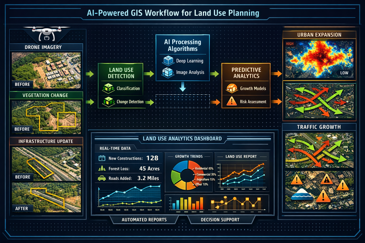
AI-Driven Land Use Change Detection and Prediction
One of the most significant advances in 2026 is the integration of artificial intelligence with GIS platforms for land use planning. AI-driven GIS systems can now automatically detect land-use and environmental changes, predict urban expansion and traffic growth, and identify infrastructure vulnerabilities[5].
These AI capabilities transform surveyors from passive documenters of existing conditions into active contributors to predictive planning:
Automated Change Detection 🔍
AI algorithms analyze sequential aerial imagery and satellite data to automatically identify:
- New construction and demolition
- Vegetation changes indicating development pressure
- Road network expansion
- Impervious surface increases affecting drainage
- Land use conversions (agricultural to residential, etc.)
Predictive Modeling
Machine learning models trained on historical development patterns can forecast:
- Areas of likely urban expansion over 5-10 year horizons
- Traffic volume increases based on development approvals
- Infrastructure capacity constraints requiring upgrades
- Environmental impact zones requiring mitigation
Infrastructure Vulnerability Assessment
With 39% of U.S. roads currently in poor condition[4], AI tools integrated with surveying workflows enable faster and more automated assessment of road cracks, guard rails, and traffic signs, improving both precision and efficiency of infrastructure development and maintenance projects.
These AI-enhanced capabilities position surveyors as strategic advisors in the land use planning process, not merely technical service providers. Understanding what property surveyors do in 2026 increasingly includes these predictive and analytical functions.
Case Study: Infrastructure Boom Application
The practical value of GIS integration for land use planning becomes clear in infrastructure-intensive projects. Consider a municipality planning a new transit corridor through an established urban area:
Project Requirements:
- Identify optimal corridor alignment minimizing property acquisition costs
- Assess environmental impacts across multiple alternatives
- Evaluate utility relocation requirements
- Analyze economic development potential along the corridor
- Engage community stakeholders with clear visualizations
GIS-Integrated Surveying Approach:
Phase 1: Data Integration
The surveyor assembles comprehensive GIS layers including:
- All property boundaries and ownership records
- Existing zoning and comprehensive plan designations
- Environmental constraints (wetlands, streams, protected areas)
- All utility locations (water, sewer, gas, electric, telecommunications)
- Topographic data with one-foot contour intervals
- Current land values and tax assessment data
- Demographic and economic data by census block
Phase 2: Corridor Analysis
Using GIS overlay analysis, the surveyor evaluates five alternative alignments across multiple criteria:
- Property acquisition costs (calculated automatically from parcel data)
- Environmental impact scores (based on constraint layer intersections)
- Utility conflict counts and estimated relocation costs
- Accessibility to existing development and transit connections
- Economic development opportunity scores
Phase 3: 3D Visualization
The surveyor creates 3D GIS models showing each alternative corridor in context, including:
- Existing buildings and proposed transit structures
- Grade changes and retaining wall requirements
- Viewshed analysis from surrounding properties
- Shadow studies for proposed elevated structures
Phase 4: Stakeholder Engagement
Web-based interactive maps allow community members to:
- Explore each alternative with detailed information
- Submit comments tied to specific locations
- View property impact assessments
- Access technical reports and supporting documentation
This comprehensive GIS-integrated approach enables the municipality to make data-driven decisions with full stakeholder transparency—a workflow impossible with traditional surveying methods.
3D GIS and Asset Lifecycle Management

The evolution of GIS Integration for Property Surveyors: Streamlining Boundary Analysis and Land Use Planning in 2026 extends beyond two-dimensional mapping into sophisticated three-dimensional modeling and long-term asset management. This represents one of the most significant opportunities for surveyors to provide ongoing value beyond traditional project boundaries.
The Shift to 3D Spatial Data
In 2026, 3D GIS combined with advanced modeling technology is creating richer, more precise models of public and private assets[3]. This intersection of 3D GIS and spatial data capture opens opportunities for surveyors to provide ongoing value, particularly for municipalities and state agencies managing aging infrastructure.
Traditional 2D GIS represents the world from a top-down perspective—adequate for many planning purposes but insufficient for:
- Complex infrastructure networks where vertical relationships matter (stacked utilities, multi-level transportation)
- Building information modeling (BIM) integration requiring accurate 3D geometry
- Volumetric calculations for excavation, material quantities, or storage capacity
- Viewshed and shadow analysis for development impact assessment
- Structural monitoring requiring precise 3D change detection
3D GIS addresses these limitations by incorporating elevation as a fundamental attribute of every spatial feature. Modern surveying equipment—laser scanners, photogrammetry drones, and mobile mapping systems—captures reality in three dimensions, and 3D GIS platforms provide the framework to manage, analyze, and visualize this rich data.
From Project Delivery to Asset Lifecycle Partnership
Traditionally, surveyors delivered final plans and data at project completion, with limited ongoing engagement. The shift to 3D GIS-based asset lifecycle management fundamentally changes this relationship.
Initial Asset Documentation 📐
Surveyors create comprehensive 3D models of new infrastructure or developments, including:
- As-built geometry with sub-centimeter accuracy
- Material specifications and construction details
- Embedded sensor locations for ongoing monitoring
- Maintenance access points and utility connections
- Integration with building information models (BIM)
Ongoing Monitoring and Updates
Rather than one-time delivery, surveyors provide periodic resurveys to detect:
- Structural deformation or settlement
- Encroachments or unauthorized modifications
- Vegetation growth affecting clearances
- Deterioration requiring maintenance intervention
Predictive Maintenance Support
By analyzing temporal 3D data, surveyors help asset owners:
- Identify deterioration trends before failure occurs
- Prioritize maintenance investments based on condition data
- Optimize inspection schedules based on change detection
- Validate contractor work quality through pre/post comparisons
This ongoing relationship model transforms surveyors from project vendors into long-term asset management partners—a significantly more valuable and sustainable business model.
Real-Time Collaboration and Decision-Making
GIS-centric asset lifecycle management is being redefined by artificial intelligence, real-time spatial insights, and secure data sharing[3]. The result includes easier real-time collaboration, smarter decision-making, reduced risk, and enhanced efficiency throughout every stage of an asset's lifecycle.
Cloud-based GIS platforms enable unprecedented collaboration:
Multi-Stakeholder Access ☁️
Project teams can simultaneously access and update spatial data:
- Surveyors upload field measurements in real-time
- Engineers reference current conditions for design decisions
- Contractors access as-built data during construction
- Facility managers update asset attributes based on maintenance activities
- Regulatory agencies review compliance documentation
Version Control and Audit Trails
All changes are tracked with timestamps and user attribution, providing:
- Complete history of data modifications
- Ability to roll back to previous versions
- Accountability for data quality
- Compliance documentation for regulatory requirements
Interoperability as Standard Practice
Construction technology vendors are expected to accelerate efforts to enhance interoperability in 2026, delivering greater value to contractors by building workflows and integrations between different software ecosystems[3]. This reduces friction in data handoffs between surveyors and clients, with clients now expecting survey data that integrates seamlessly regardless of their existing technology stack.
Firms that deliver survey data optimized for 3D visualization and BIM integration are positioning themselves as essential partners in collaborative workflows rather than simply vendors of measurement services[3]—a crucial competitive differentiation.
For surveyors working on commercial properties, understanding commercial property surveying services provides context for how 3D GIS integration enhances value delivery.
Practical Implementation: Tools and Workflows for 2026
Understanding the theoretical benefits of GIS Integration for Property Surveyors: Streamlining Boundary Analysis and Land Use Planning in 2026 is valuable, but practical implementation requires specific tools, workflows, and best practices. This section provides actionable guidance for surveyors at various stages of GIS adoption.
Step-by-Step GIS Integration Workflow
A systematic approach to GIS integration ensures data quality and maximizes efficiency gains:
Step 1: Data Inventory and Assessment 📋
Before implementing GIS workflows, surveyors should:
- Catalog all existing survey data (file formats, coordinate systems, storage locations)
- Assess data quality and completeness
- Identify gaps requiring new data collection
- Determine coordinate system standardization requirements
- Evaluate data security and backup procedures
Step 2: Platform Selection and Configuration
Choose GIS software based on:
- Project types and client requirements
- Budget constraints and licensing models
- Integration needs with existing equipment and software
- Staff technical capabilities and training requirements
- Scalability for future growth
Configure the selected platform with:
- Standardized coordinate systems and map projections
- Custom symbology and layer styling for consistency
- Automated quality control rules and topology checks
- Template maps and layouts for common deliverables
- Data import/export workflows for client formats
Step 3: Data Migration and Standardization
Convert existing survey data to GIS format:
- Import CAD drawings, converting blocks to GIS features
- Georeference historical maps and imagery
- Structure attribute data in standardized schemas
- Establish relationships between related features
- Validate geometry and fix topology errors
Step 4: Field Data Collection Integration
Connect field equipment to GIS workflows:
- Configure GPS/GNSS receivers for real-time data upload
- Set up mobile GIS apps for field verification
- Establish drone flight planning and data processing pipelines
- Create field forms for consistent attribute collection
- Test data synchronization and conflict resolution
Step 5: Analysis and Visualization Development
Build reusable analysis tools and map templates:
- Create model workflows for common analyses (buffers, overlays, proximity)
- Develop 3D visualization templates for client presentations
- Configure web maps for stakeholder engagement
- Build automated report generation tools
- Establish quality control checkpoints
Step 6: Client Delivery and Collaboration
Optimize data delivery for client integration:
- Provide data in multiple formats (GIS, CAD, PDF, web services)
- Create interactive web maps for non-technical stakeholders
- Establish cloud-based collaboration platforms
- Develop training materials for client data use
- Set up ongoing data update and maintenance agreements
Essential GIS Skills for Property Surveyors in 2026
Successful GIS integration requires surveyors to develop new competencies beyond traditional measurement skills:
Technical Skills 💻
- Spatial database design and management
- Coordinate system transformations and projections
- Geoprocessing and spatial analysis methods
- 3D modeling and visualization techniques
- Scripting and automation (Python, JavaScript)
- Web mapping and application development
Data Management Skills
- Metadata creation and maintenance
- Data quality assessment and improvement
- Version control and change tracking
- Backup and disaster recovery procedures
- Data security and privacy compliance
Communication Skills
- Translating technical spatial analysis into business insights
- Creating compelling visualizations for diverse audiences
- Presenting complex spatial relationships clearly
- Training clients on data use and interpretation
- Collaborating across multidisciplinary project teams
Many of these skills can be developed through professional development programs, online courses, and vendor training. Understanding surveyor qualifications and credentials helps establish professional development priorities.
Common Implementation Challenges and Solutions
Surveyors implementing GIS integration often encounter predictable challenges. Anticipating these obstacles and planning appropriate responses accelerates successful adoption:
Challenge: Data Quality and Consistency Issues
Problem: Legacy survey data exists in inconsistent formats, coordinate systems, and quality levels, making integration difficult.
Solution:
- Establish data quality standards before migration begins
- Implement phased conversion, prioritizing recent/high-value projects
- Use automated quality control tools to identify and flag issues
- Accept that some historical data may require field verification
- Document data lineage and quality metadata for all datasets
Challenge: Staff Resistance and Training Gaps
Problem: Experienced surveyors comfortable with traditional methods resist adopting new GIS workflows.
Solution:
- Demonstrate efficiency gains with pilot projects on actual client work
- Provide hands-on training with immediate practical application
- Start with simple GIS tasks before advancing to complex analysis
- Celebrate early wins and share success stories across the team
- Consider hiring GIS specialists to support traditional surveyors
Challenge: Technology Integration Complexity
Problem: GIS software must integrate with existing survey equipment, CAD systems, and client platforms, creating technical complexity.
Solution:
- Prioritize platforms with proven integration capabilities
- Work with vendors to establish tested data exchange workflows
- Develop standardized import/export procedures
- Maintain equipment firmware and software at compatible versions
- Budget for technical support during initial implementation
Challenge: Client Education and Expectation Management
Problem: Clients may not understand GIS capabilities or how to use delivered spatial data effectively.
Solution:
- Provide sample visualizations early in project discussions
- Offer tiered deliverable options (basic to advanced GIS products)
- Include brief training sessions as part of project delivery
- Create user guides specific to each client's technology environment
- Position GIS capabilities as value-added services, not cost increases
Market-Driven Use Cases: Infrastructure and Development Booms
The surveying profession entered 2026 amid accelerating digital transformation, driven by pressure to deliver faster, more accurate results while addressing workforce shortages and evolving client expectations[3]. This transformation is particularly evident in infrastructure-intensive sectors experiencing significant investment and growth.
Transportation Infrastructure Modernization
Aging transportation infrastructure across developed nations is driving unprecedented investment in road, bridge, rail, and transit improvements. GIS Integration for Property Surveyors: Streamlining Boundary Analysis and Land Use Planning in 2026 provides essential capabilities for these complex projects:
Corridor Planning and Right-of-Way Acquisition 🛣️
- Multi-criteria route analysis incorporating engineering, environmental, and cost factors
- Automated parcel impact assessment for hundreds of properties
- Visual simulation of alternatives for public engagement
- Integration with appraisal and acquisition management systems
Utility Coordination and Conflict Resolution
- 3D visualization of existing utilities relative to proposed improvements
- Clash detection between design elements and existing infrastructure
- Relocation cost estimation based on spatial analysis
- Coordination platform for multiple utility owners
Construction Monitoring and Quality Control
- As-built verification through periodic resurveys
- Automated comparison of constructed conditions to design intent
- Progress tracking tied to spatial locations
- Change order documentation with spatial context
Urban Development and Densification
Population growth and urban migration are intensifying development pressure in metropolitan areas. GIS-equipped surveyors provide critical support for:
Mixed-Use Development Planning
- Zoning analysis for complex mixed-use proposals
- Shadow and viewshed studies for high-rise projects
- Parking and loading facility optimization
- Pedestrian connectivity and walkability analysis
Infill Development Feasibility
- Automated identification of developable parcels meeting size/zoning criteria
- Utility capacity analysis for potential development sites
- Environmental constraint screening
- Market analysis integration (demographics, comparable properties)
Affordable Housing Site Selection
- Transit accessibility scoring for potential sites
- Community amenity proximity analysis
- Development incentive zone identification
- Fair housing compliance documentation
Environmental Compliance and Sustainability
Increasing environmental regulations and sustainability goals create demand for sophisticated spatial analysis:
Wetland and Stream Delineation
- Integration of field-verified boundaries with regulatory databases
- Buffer calculation and buildable area determination
- Impact quantification for permit applications
- Mitigation site identification and tracking
Stormwater Management Planning
- Watershed delineation and flow path modeling
- Impervious surface calculation and tracking
- Low-impact development site suitability analysis
- Post-construction monitoring and verification
Climate Resilience Assessment
- Flood risk mapping with multiple return periods
- Sea level rise and coastal erosion vulnerability
- Heat island effect analysis and mitigation planning
- Green infrastructure opportunity identification
These market-driven applications demonstrate how GIS integration transforms surveyors from measurement technicians into strategic advisors on complex spatial problems. For residential applications, understanding residential surveying services shows how GIS adds value even in simpler projects.
Energy and Utilities Infrastructure
Renewable energy expansion and utility modernization create specialized GIS opportunities:
Solar Farm and Wind Energy Siting
- Terrain analysis for optimal panel placement and energy generation
- Transmission line routing and interconnection feasibility
- Environmental and cultural resource conflict identification
- Property acquisition and easement mapping
Electric Grid Modernization
- Asset inventory and condition assessment
- Vegetation management and clearance monitoring
- Outage analysis and system reliability improvement
- Integration with smart grid sensor networks
Pipeline and Linear Infrastructure
- Route optimization across multiple criteria
- Crossing identification and permitting support
- Integrity monitoring and risk assessment
- Emergency response planning and coordination
Visualization Benefits: Transforming Client Communication
Perhaps the most immediate and universally appreciated benefit of GIS Integration for Property Surveyors: Streamlining Boundary Analysis and Land Use Planning in 2026 is the dramatic improvement in how survey information is communicated to clients and stakeholders. Traditional survey deliverables—technical plans filled with bearings, distances, and specialized symbols—remain essential for legal and construction purposes, but they often fail to communicate effectively with decision-makers who lack technical training.
From Technical Plans to Intuitive Visualizations
GIS platforms enable surveyors to transform the same underlying data into multiple presentation formats optimized for different audiences:
Executive Dashboards 📊
High-level decision-makers need quick insights without technical detail:
- Key metrics displayed prominently (total acreage, buildable area, compliance status)
- Color-coded maps showing go/no-go zones
- Comparison charts for alternative scenarios
- Risk indicators and decision recommendations
Interactive Web Maps
Stakeholders want to explore data at their own pace:
- Zoom and pan to areas of interest
- Toggle layers on/off to focus on specific information
- Click features for detailed attribute information
- Measure distances and areas directly on the map
- Print or export custom map views
3D Visualizations and Animations
Complex spatial relationships become clear in three dimensions:
- Proposed development shown in context with existing surroundings
- Viewshed analysis from multiple vantage points
- Shadow studies across seasons and times of day
- Flythrough animations for stakeholder presentations
- Before/after comparisons for impact assessment
Mobile-Optimized Deliverables
Decision-makers access information from any device:
- Responsive web maps that adapt to screen size
- GPS-enabled field verification apps
- Offline access for areas without connectivity
- Photo integration tied to map locations
- Real-time update notifications
Case Example: Transforming Client Decision-Making
Consider a commercial developer evaluating three potential sites for a mixed-use project. Traditional survey deliverables would provide separate technical plans for each site, requiring the client to mentally compare complex information across multiple documents.
With GIS-integrated visualization, the surveyor provides:
Comparative Dashboard
A single screen showing all three sites side-by-side with:
- Aerial imagery with proposed building footprints overlaid
- Color-coded zoning compliance (green = compliant, yellow = variance required, red = prohibited)
- Utility availability scores (water, sewer, electric, gas capacity)
- Access and circulation ratings based on traffic analysis
- Development cost estimates derived from spatial analysis
Interactive Site Explorer
A web map allowing the client to:
- Switch between sites with a dropdown menu
- Toggle between current conditions and proposed development
- View detailed information on any constraint or opportunity
- Compare financial pro formas linked to spatial attributes
- Share specific map views with project team members via URL
3D Impact Visualization
Photorealistic renderings showing:
- Proposed buildings in context with surrounding development
- Views from adjacent properties and public spaces
- Shadow impacts on neighboring buildings
- Pedestrian experience at street level
- Integration with planned transit improvements
This comprehensive visualization package enables the client to make an informed site selection decision in days rather than weeks—and with far greater confidence in the spatial implications of their choice.
Visualization Best Practices for Surveyors
Creating effective visualizations requires more than technical GIS skills. Surveyors should consider:
Know Your Audience 🎯
- Technical stakeholders need precision and detail
- Executives need high-level insights and recommendations
- Public audiences need intuitive, jargon-free presentations
- Regulatory agencies need compliance-focused documentation
Use Color Strategically
- Limit color palettes to 5-7 distinct colors
- Use intuitive color associations (green = good, red = problem, blue = water)
- Ensure sufficient contrast for accessibility
- Maintain consistency across related maps
Provide Context and Scale
- Always include north arrows and scale bars
- Show recognizable landmarks for orientation
- Use basemaps (aerial imagery, streets) appropriate to the subject
- Include inset maps showing regional context
Layer Information Progressively
- Start with essential information, add detail as needed
- Use transparency to show overlapping features
- Provide layer controls for user customization
- Avoid cluttered maps that overwhelm viewers
Tell a Story
- Organize visualizations in logical sequence
- Use titles and annotations to guide interpretation
- Highlight key findings and recommendations
- Provide clear next steps or decision points
Future Trends and Emerging Technologies
While GIS Integration for Property Surveyors: Streamlining Boundary Analysis and Land Use Planning in 2026 represents current best practice, the technology landscape continues to evolve rapidly. Surveyors who anticipate emerging trends can position themselves advantageously for the next phase of digital transformation.
Artificial Intelligence and Machine Learning Expansion
AI integration with GIS will accelerate beyond current applications:
Automated Feature Extraction 🤖
- AI algorithms automatically identify buildings, roads, vegetation, and other features from imagery
- Reduces manual digitizing time by 80-90%
- Enables rapid large-area mapping updates
- Improves consistency and reduces human error
Predictive Analytics
- Machine learning models forecast development patterns, property values, and infrastructure needs
- Risk assessment for natural hazards, structural failure, and regulatory changes
- Optimization algorithms for route planning, site selection, and resource allocation
Natural Language Interfaces
- Query GIS databases using conversational language ("Show me all commercial parcels over 2 acres within 1 mile of transit")
- Automated report generation from spatial analysis results
- Voice-controlled field data collection
Digital Twin Integration
Digital twins—virtual replicas of physical assets updated with real-time sensor data—represent the convergence of GIS, BIM, and IoT:
Real-Time Asset Monitoring
- Continuous data feeds from sensors embedded in infrastructure
- Automated anomaly detection and alert generation
- Predictive maintenance based on actual performance data
- Integration of surveying data with operational systems
Scenario Planning and Simulation
- Test infrastructure changes in virtual environment before construction
- Model impacts of natural disasters or system failures
- Optimize maintenance schedules and resource allocation
- Support emergency response planning and training
Blockchain for Land Records
Blockchain technology promises to transform property records and land administration:
Immutable Transaction Records
- Permanent, tamper-proof record of all property transactions
- Reduced fraud and title disputes
- Faster, more efficient property transfers
- Integration of survey data with ownership records
Smart Contracts for Easements and Rights
- Automated enforcement of easement terms
- Transparent tracking of rights and restrictions
- Reduced administrative overhead
- Improved compliance monitoring
Extended Reality (XR) for Visualization
Augmented reality (AR) and virtual reality (VR) will transform how survey data is experienced:
Augmented Reality Field Verification 🥽
- Overlay proposed designs on actual site conditions through AR glasses
- View underground utilities before excavation
- Real-time guidance for monument location and setting
- Enhanced safety through hazard visualization
Virtual Reality Stakeholder Engagement
- Immersive experience of proposed developments
- Walk-through virtual environments at 1:1 scale
- Collaborative design review in shared virtual spaces
- Enhanced public understanding and engagement
Conclusion: Embracing GIS Integration for Competitive Advantage
The transformation of property surveying through GIS Integration for Property Surveyors: Streamlining Boundary Analysis and Land Use Planning in 2026 represents far more than technological upgrade—it fundamentally redefines the surveyor's role from measurement specialist to spatial intelligence advisor. As infrastructure investment accelerates, urban development intensifies, and environmental concerns grow more pressing, the ability to integrate, analyze, and visualize complex spatial data becomes increasingly valuable.
Surveyors who have embraced GIS integration report significant competitive advantages:
✅ Increased Efficiency: Automated workflows and data reuse reduce project delivery times by 30-50%
✅ Enhanced Client Value: Visualization-ready deliverables and decision-support analysis command premium fees
✅ Expanded Service Offerings: Asset lifecycle management and ongoing monitoring create recurring revenue streams
✅ Improved Accuracy: Automated quality control and multi-source data integration reduce errors and omissions
✅ Stronger Collaboration: Cloud-based platforms and interoperable data enable seamless project team coordination
The surveying profession's digital transformation will continue accelerating, driven by workforce shortages, client expectations, and technological capabilities[3]. Firms that position themselves as GIS-integrated spatial intelligence providers—rather than traditional measurement services—will thrive in this evolving landscape.
Actionable Next Steps
For surveyors ready to advance their GIS integration capabilities:
1. Assess Current Capabilities 📝
- Inventory existing data, software, and staff skills
- Identify gaps between current state and desired capabilities
- Prioritize improvements based on client needs and market opportunities
2. Invest in Training and Tools
- Allocate budget for GIS software, hardware, and professional development
- Start with platform fundamentals before advancing to specialized applications
- Engage vendors for implementation support and best practices guidance
3. Pilot with Strategic Projects
- Select client projects that benefit most from GIS integration
- Document efficiency gains and quality improvements
- Develop case studies and visualizations for business development
4. Build Collaborative Relationships
- Partner with GIS specialists, planners, and engineers on multidisciplinary projects
- Join professional organizations focused on geospatial technology
- Participate in industry forums and knowledge-sharing communities
5. Market Your Enhanced Capabilities
- Update marketing materials to showcase GIS integration and visualization
- Develop sample deliverables demonstrating value to potential clients
- Target infrastructure-intensive sectors experiencing growth and investment
The future of property surveying is spatial intelligence—comprehensive understanding of how multiple data layers interact to create opportunities, constraints, and insights. GIS integration provides the platform for delivering this intelligence effectively. Surveyors who master these capabilities will not only survive the digital transformation but emerge as indispensable strategic partners in shaping the built environment.
For surveyors seeking to understand the full scope of modern surveying services, exploring different types of surveys provides valuable context for where GIS integration adds the most value. The journey toward comprehensive GIS integration may seem daunting, but the competitive advantages and professional satisfaction of delivering transformative spatial intelligence make it one of the most worthwhile investments a surveying firm can make in 2026 and beyond.
References
[1] The Future Of Land Surveying Technology And Upcoming Trends In 2026 – https://metricop.com/blogs/land-surveying/the-future-of-land-surveying-technology-and-upcoming-trends-in-2026
[2] How Land Surveying And Gis Collaborate – https://nexgensurveying.com/blog/how-land-surveying-and-gis-collaborate/
[3] Doubling Down On Digital – https://amerisurv.com/2026/02/01/doubling-down-on-digital/
[4] How Ai Is Changing The Role Of The Surveyor In Aec – https://www.gim-international.com/content/article/how-ai-is-changing-the-role-of-the-surveyor-in-aec
[5] Evolution Of Gis Mapping Trends Technologies 2026 – https://asecaddesign.com/blogs/evolution-of-gis-mapping-trends-technologies-2026/
[6] With Gis Technology Drone Industry Alights In Reality – https://www.esri.com/about/newsroom/arcnews/with-gis-technology-drone-industry-alights-in-reality