
The land surveying industry stands at a revolutionary crossroads in 2026. What once required weeks of manual fieldwork, multiple crew members, and extensive post-processing now takes mere hours with cutting-edge technology. The Top Emerging Land Surveying Technologies Shaping 2026: Drones, AI, and Beyond are fundamentally transforming how property surveyors capture, analyze, and deliver spatial data to clients across construction, urban planning, and real estate sectors.
Gone are the days when surveyors relied solely on traditional theodolites and measuring chains. Today's professionals harness unmanned aerial vehicles (UAVs), artificial intelligence algorithms, and mobile 3D mapping systems to deliver unprecedented accuracy and efficiency. These technological advancements are not just improving existing processes—they're opening entirely new possibilities for what surveying can accomplish.
This comprehensive guide explores the breakthrough technologies revolutionizing land surveying in 2026, examining how drones with LiDAR sensors, AI-powered data analysis, and cloud-based collaboration platforms are delivering measurable efficiency gains and cost reductions. Whether you're a property owner considering a survey or a professional looking to understand industry trends, understanding these emerging technologies is essential for making informed decisions about surveying services.
Key Takeaways
- 🚁 Drone technology with LiDAR integration has evolved from niche specialty to industry standard, enabling surveyors to capture detailed topographic data across large areas in a fraction of traditional timeframes
- 🎯 Centimeter-level GPS accuracy through RTK positioning systems delivers precision previously impossible with consumer-grade equipment, transforming survey reliability
- 🤖 AI and machine learning algorithms automate data analysis that once required days of manual processing, identifying patterns and predicting terrain changes with minimal human intervention
- 📱 Mobile 3D mapping systems allow surveyors to create comprehensive spatial models from diverse environments without bulky equipment, increasing operational flexibility
- ☁️ Cloud-based data management enables real-time collaboration and instant access to survey data from any location, revolutionizing project coordination and client communication
Understanding the Technology Revolution in Land Surveying
The Shift from Traditional to Technology-Driven Surveying
Land surveying has undergone more transformation in the past five years than in the previous fifty. Traditional surveying methods—while still valuable in certain contexts—required extensive manual labor, multiple site visits, and considerable time investment. A typical boundary survey might take several days of fieldwork followed by weeks of data processing and report preparation.
The Top Emerging Land Surveying Technologies Shaping 2026: Drones, AI, and Beyond have compressed these timelines dramatically. What distinguishes 2026 from previous years is not just the existence of these technologies, but their widespread accessibility and integration. Equipment that cost hundreds of thousands of dollars just a few years ago is now available at price points that make adoption feasible for small and medium-sized surveying firms.
This democratization of advanced surveying technology means property owners and developers benefit from:
- Faster project completion with reduced surveying timelines
- Lower costs due to decreased labor requirements
- Higher accuracy from precision instruments and automated processing
- Better visualization through 3D models and detailed topographic maps
- Improved decision-making supported by comprehensive spatial data
For those considering property surveys, understanding these technological capabilities helps set realistic expectations. Modern chartered surveyors equipped with advanced tools can deliver insights that would have been impossible or prohibitively expensive using traditional methods alone.
Why 2026 Represents a Tipping Point
Several converging factors make 2026 particularly significant for surveying technology adoption:
Affordability threshold reached: Drone systems with professional-grade cameras and LiDAR sensors have dropped below critical price points, making them standard equipment rather than luxury investments[1].
AI maturity: Machine learning algorithms have progressed from experimental to production-ready, with proven track records in data processing and pattern recognition[1].
Regulatory clarity: Aviation authorities worldwide have established clearer frameworks for commercial drone operations, reducing legal barriers to adoption.
Client expectations: Property developers, construction firms, and real estate professionals now expect digital deliverables including 3D models, interactive maps, and cloud-accessible data rather than traditional paper reports.
Integration ecosystems: Software platforms now seamlessly connect drone data capture, AI processing, CAD modeling, and GIS analysis in unified workflows[3].
Drone Technology: The New Standard in Aerial Surveying
How UAVs Are Transforming Data Collection
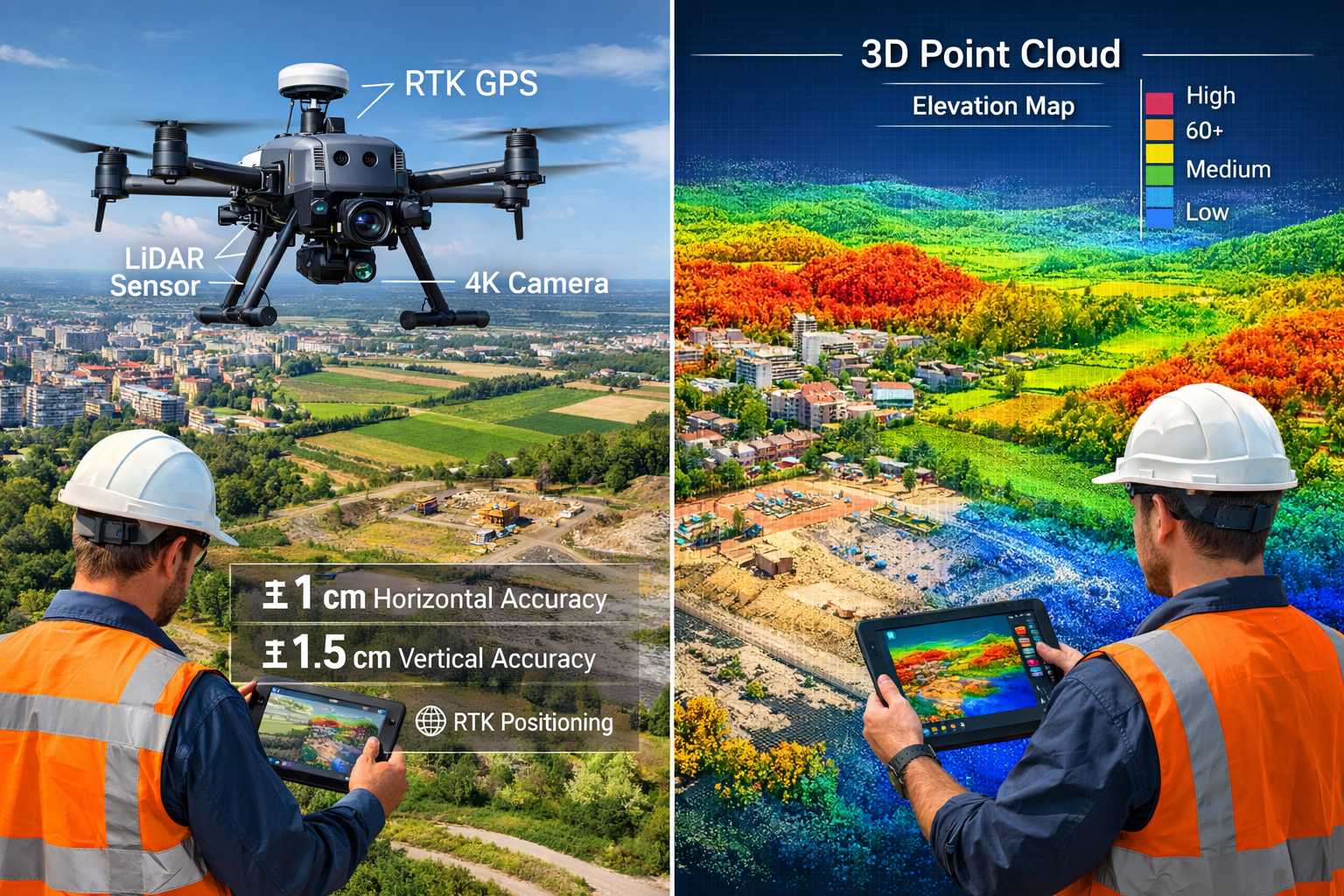
Unmanned aerial vehicles equipped with high-resolution cameras and advanced sensors have transitioned from novelty to necessity in land surveying operations. In 2026, drones represent the primary data collection method for topographic surveys, construction monitoring, and large-area mapping projects[1].
The advantages of drone-based surveying are compelling:
| Traditional Ground Survey | Drone-Based Survey |
|---|---|
| 5-10 acres per day coverage | 50-100+ acres per day coverage |
| Limited terrain accessibility | Access to difficult or dangerous areas |
| Ground-level perspective only | Comprehensive aerial perspective |
| Multiple crew members required | Single operator sufficient |
| Weather-dependent fieldwork | Flexible scheduling with quick deployment |
| Days to weeks for data collection | Hours for equivalent coverage |
Modern surveying drones capture thousands of high-resolution images during a single flight, which specialized software then processes into detailed orthomosaic maps, digital elevation models, and 3D terrain representations. This photogrammetric approach creates spatial data with accuracy rivaling traditional ground-based methods while covering vastly larger areas[1].
LiDAR Integration: The Cutting Edge of Precision
While standard photogrammetry serves many surveying needs, LiDAR (Light Detection and Ranging) technology represents the premium tier of drone-based surveying. LiDAR systems emit laser pulses—often hundreds of thousands per second—measuring the time each pulse takes to return after reflecting off surfaces below[1].
This laser scanning approach offers distinct advantages:
- Vegetation penetration: LiDAR pulses can pass through tree canopy gaps to measure ground elevation beneath dense forest cover
- Precise elevation data: Direct distance measurement produces highly accurate terrain models
- Detailed feature capture: Complex structures, infrastructure, and landscape features are recorded with exceptional detail
- Consistent accuracy: Unlike photogrammetry, LiDAR performance doesn't degrade in low-contrast or shadowed areas
Drone-based LiDAR combines the aerial perspective and coverage efficiency of UAVs with the precision and penetration capabilities of laser scanning. This combination has become particularly valuable for:
- Corridor mapping for utilities and transportation infrastructure
- Forestry and environmental surveying
- Flood modeling and watershed analysis
- Archaeological site documentation
- Quarry and mining volume calculations
For property owners requiring comprehensive surveys of larger estates or complex terrain, understanding whether your surveyor employs LiDAR technology can help you assess the thoroughness and accuracy of the proposed survey approach. Professional building surveys increasingly incorporate drone data to supplement traditional ground-based inspection methods.
RTK and PPK: Achieving Centimeter-Level Accuracy
The accuracy of drone surveying depends heavily on precise positioning data. Consumer-grade GPS systems typically achieve accuracy of 3-5 meters—insufficient for professional surveying applications. High-end commercial GPS systems using Real-Time Kinematic (RTK) technology can achieve precision down to the centimeter in clear sky conditions[3][4].
RTK positioning works by:
- Establishing a base station at a known, surveyed location
- Receiving GPS signals at both the base station and the drone simultaneously
- Calculating corrections based on the difference between the base station's known position and its GPS-indicated position
- Transmitting these corrections to the drone in real-time
- Applying corrections to achieve centimeter-level positioning accuracy
Post-Processing Kinematic (PPK) offers an alternative approach that records raw GPS data during flight and applies corrections afterward using data from permanent reference stations. This method provides similar accuracy without requiring real-time radio communication between base station and drone[1].
These positioning enhancements transform drone surveying from approximate mapping to survey-grade precision, making UAV-captured data suitable for boundary determination, construction layout, and legal documentation purposes.
Autonomous Operations and Drone Swarms
The evolution toward autonomous drone operations represents another significant advancement in 2026. Modern surveying drones can:
- Follow pre-programmed flight paths with minimal operator intervention
- Automatically adjust altitude to maintain consistent ground sampling distance over varying terrain
- Detect and avoid obstacles using onboard sensors
- Return to launch point and land safely if battery levels become critical
- Resume interrupted surveys from the last captured image
More advanced implementations include drone swarms—multiple UAVs working cooperatively to survey large areas simultaneously[3]. While still emerging, swarm technology promises to further compress surveying timelines by distributing data collection across multiple platforms operating in coordination.
For surveying firms, autonomous capabilities reduce the skill level required for basic operations, allowing experienced professionals to focus on mission planning, data analysis, and client consultation rather than manual flight control.
Artificial Intelligence and Machine Learning in Survey Data Processing
Automating the Analysis Pipeline
Perhaps no technology is transforming surveying more fundamentally than artificial intelligence. The Top Emerging Land Surveying Technologies Shaping 2026: Drones, AI, and Beyond place AI at the center of the data processing revolution, addressing what has historically been surveying's biggest bottleneck: converting raw field data into actionable information[1].
A single drone flight over a 50-acre site might capture 2,000+ high-resolution images totaling hundreds of gigabytes. Traditional processing required surveyors to:
- Manually review and organize images
- Identify and mark ground control points
- Configure photogrammetry software parameters
- Monitor processing jobs that might run for days
- Review outputs for errors and artifacts
- Extract specific measurements and features
- Prepare deliverable maps and models
Machine learning algorithms now automate much of this workflow:
✅ Automatic image classification identifies and categorizes features (buildings, vegetation, water, roads, etc.)
✅ Pattern recognition detects ground control points and survey markers without manual identification
✅ Quality assessment flags problematic images with motion blur, incorrect exposure, or insufficient overlap
✅ Feature extraction automatically identifies and measures specific elements like building footprints, utility poles, or drainage features
✅ Change detection compares datasets from different dates to identify modifications, erosion, or construction progress
✅ Anomaly identification highlights unusual patterns that may indicate errors or areas requiring closer examination
This automation reduces processing time from days to hours while maintaining—and often improving—accuracy through consistent application of validated algorithms[1].
Predictive Analytics for Risk Assessment
Beyond processing existing data, AI enables predictive applications that extend surveying's value proposition. Machine learning models trained on historical data can:
- Predict flood risk by analyzing terrain, drainage patterns, soil types, and historical weather data
- Identify landslide susceptibility based on slope angles, soil composition, vegetation cover, and precipitation patterns
- Forecast erosion along coastlines, riverbanks, or construction sites
- Estimate vegetation growth for landscape planning and environmental impact assessment
- Project settlement patterns for structures on various soil types
While these predictive applications remain in relatively early development stages, they represent promising directions for AI integration in surveying services[1]. Property owners and developers increasingly value not just current conditions but informed projections about future site behavior.
For those commissioning surveys, asking whether AI-powered analysis is included can reveal whether you're receiving basic data collection or comprehensive spatial intelligence. Advanced structural surveys may incorporate AI-assisted analysis to identify potential issues that human inspectors might overlook.
Machine Vision for Defect Detection
AI-powered computer vision algorithms excel at identifying visual patterns and anomalies. In surveying and property inspection contexts, this capability enables:
- Crack detection in pavement, concrete structures, or building facades
- Vegetation encroachment identification along utility corridors or property boundaries
- Drainage issue recognition through water pooling or erosion patterns
- Material deterioration assessment on roofs, walls, or infrastructure
- Unauthorized modifications detection by comparing current conditions to approved plans
These applications complement traditional surveying by adding a quality assessment layer to spatial data collection. Rather than simply documenting what exists, AI-enhanced surveys can flag conditions requiring attention or further investigation.
Natural Language Processing for Report Generation
An emerging AI application in surveying involves automated report generation. Natural language processing algorithms can:
- Analyze survey data and measurements
- Compare findings against regulatory requirements or project specifications
- Generate narrative descriptions of site conditions
- Highlight deviations from expected parameters
- Produce preliminary reports requiring only professional review and approval
This capability addresses another time-consuming aspect of surveying work, allowing professionals to deliver faster turnaround while maintaining quality standards. The surveyor's expertise shifts from data transcription to strategic interpretation and client consultation.
Mobile 3D Mapping and Real-Time Data Capture
Handheld and Vehicle-Mounted Systems
While drones dominate discussions of surveying innovation, mobile 3D mapping systems represent equally transformative technology for many applications. These portable devices combine multiple sensors—including cameras, LiDAR scanners, and inertial measurement units—to capture detailed spatial data while the operator walks through or drives past the survey area[1].
Mobile mapping excels in scenarios where drones face limitations:
🏢 Indoor environments: Building interiors, tunnels, parking structures, and other enclosed spaces inaccessible to aerial platforms
🌳 Dense canopy areas: Forests or urban settings where overhead obstructions prevent drone operations
🚗 Linear infrastructure: Roads, railways, and utility corridors where vehicle-mounted systems efficiently capture continuous data
⚡ Quick-response situations: Emergency assessments, accident documentation, or time-sensitive inspections requiring immediate deployment
The key advantage is operational flexibility. A surveyor can arrive on-site and begin capturing data within minutes, without flight planning, airspace authorization, or weather considerations that govern drone operations.
Real-Time Visualization and Quality Control
Modern mobile mapping systems provide instant feedback through real-time visualization on connected tablets or computers. As the operator moves through the environment, they can:
- View the developing 3D model in real-time
- Identify coverage gaps requiring additional passes
- Verify that critical features have been adequately captured
- Adjust scanning parameters for challenging materials or lighting conditions
- Confirm data quality before leaving the site
This immediate quality control eliminates the frustrating scenario of discovering data gaps or quality issues only after returning to the office and beginning processing. The surveyor can confidently leave the site knowing comprehensive data has been captured.
For property surveys, this technology enables more thorough documentation of existing conditions. A Level 3 building survey might incorporate mobile 3D scanning to create detailed as-built models of interior spaces, documenting spatial relationships and conditions with millimeter-level precision.
Integration with BIM and Digital Twins
Mobile 3D mapping data integrates seamlessly with Building Information Modeling (BIM) workflows, creating accurate as-built models for renovation planning, facility management, or historical documentation. The captured point clouds can be:
- Converted into parametric BIM objects (walls, floors, structural elements)
- Compared against design models to verify construction accuracy
- Used as base data for renovation or expansion planning
- Incorporated into digital twin platforms for ongoing facility monitoring
This integration bridges the gap between physical reality and digital planning tools, ensuring design decisions are based on accurate existing conditions rather than assumptions or outdated documentation.
Cloud Processing and Accessibility
Like drone data, mobile mapping outputs benefit from cloud-based processing and storage[3]. Survey data uploads to cloud platforms where:
- Powerful servers handle computationally intensive processing tasks
- Multiple team members can access and work with data simultaneously
- Clients receive secure links to view and interact with 3D models
- Version control maintains data integrity across project lifecycles
- Long-term archival preserves historical records without local storage constraints
This cloud infrastructure enables new collaboration models where surveyors, architects, engineers, and clients all reference the same authoritative spatial data throughout project development.
GPS and Positioning Technology Advances

From Meter-Level to Centimeter-Level Precision
The evolution of GPS accuracy underpins many surveying technology improvements. Standard consumer GPS—like that in smartphones—provides position accuracy of 3-5 meters under ideal conditions, degrading further in urban canyons or under tree cover. This precision suffices for navigation but falls far short of surveying requirements[3][4].
Survey-grade GPS receivers using RTK correction achieve centimeter-level accuracy, representing a hundredfold improvement. This precision enables:
- Boundary determination for property surveys
- Construction layout and verification
- Precise georeferencing of drone and mobile mapping data
- Monitoring of structural movement or ground subsidence
- Coordination between different survey datasets
The technology works by comparing GPS signals received at two locations simultaneously—a base station at a known position and a rover at the position being determined. By analyzing the differences in signals received at both locations, the system can calculate and correct for atmospheric disturbances, satellite orbit errors, and other factors that degrade absolute GPS accuracy.
Multi-Constellation GNSS
Modern survey receivers don't rely solely on the U.S. GPS satellite constellation. Global Navigation Satellite System (GNSS) receivers access multiple satellite networks simultaneously:
- GPS (United States) – 31 satellites
- GLONASS (Russia) – 24 satellites
- Galileo (European Union) – 30 satellites
- BeiDou (China) – 35 satellites
By tracking satellites from multiple constellations, receivers achieve:
- Improved availability: More satellites visible from any location
- Better geometry: Optimal satellite positioning for accuracy
- Faster initialization: Quicker achievement of RTK fixed solutions
- Enhanced reliability: Redundancy if one constellation experiences issues
This multi-constellation approach is particularly valuable in challenging environments like urban areas with tall buildings or heavily forested regions where satellite visibility is limited.
Network RTK and Virtual Reference Stations
Traditional RTK surveying required establishing a physical base station at a known point for each project—a time-consuming setup process. Network RTK services eliminate this requirement by providing correction data from networks of permanent reference stations[4].
Surveyors subscribe to these services and receive corrections via cellular data connection, enabling:
- Immediate start of surveying without base station setup
- Consistent accuracy across large geographic areas
- Reduced equipment requirements and setup time
- Seamless transition between project sites
These networks calculate virtual reference station corrections specific to the rover's approximate location, providing accuracy equivalent to having a dedicated base station nearby without the setup overhead.
Remote Sensing and Satellite Technology
Multispectral and Hyperspectral Imaging
Beyond visible light photography, multispectral and hyperspectral imaging expands surveying capabilities into wavelengths invisible to human eyes. These sensors capture data across numerous spectral bands, revealing information about:
🌱 Vegetation health: Chlorophyll content, water stress, disease presence, and growth vigor through near-infrared and red-edge bands
💧 Water quality: Sediment levels, algae presence, and pollution indicators in water bodies
🏗️ Material composition: Distinguishing between different construction materials, soil types, or ground cover
🌡️ Thermal characteristics: Temperature variations indicating moisture intrusion, insulation defects, or underground features
This spectral data adds analytical depth beyond spatial geometry, enabling surveyors to assess conditions and characteristics not visible in standard imagery[2].
Satellite-Based Monitoring for Large Areas
While drones excel at detailed surveys of specific sites, satellite remote sensing provides the only practical method for monitoring vast areas or conducting regional analysis. Modern Earth observation satellites offer:
- Frequent revisit times: Some satellites image the same location daily or weekly
- Consistent coverage: Systematic data collection across entire regions
- Historical archives: Decades of imagery for change analysis
- Multiple resolutions: From sub-meter detail to continental-scale coverage
Surveying applications include:
- Land use classification and change detection
- Environmental monitoring and compliance verification
- Agricultural assessment and crop monitoring
- Urban growth tracking and planning
- Natural disaster assessment and response
For property-related applications, satellite data can provide context about surrounding area development, environmental conditions, or regional trends that influence specific site characteristics.
Integration of Multi-Scale Data
The most powerful surveying approaches in 2026 integrate data across multiple scales and sources:
- Satellite imagery provides regional context and historical perspective
- Drone surveys capture detailed site-specific information
- Mobile mapping documents ground-level features and structures
- Traditional ground surveys verify critical measurements and boundaries
This multi-scale integration creates comprehensive spatial intelligence that no single technology can provide alone. Understanding what surveyors look for helps property owners appreciate how different data sources contribute to thorough assessment.
Cloud Computing and Data Management Infrastructure
Centralized Data Repositories
The massive datasets generated by modern surveying technologies—often hundreds of gigabytes per project—require robust data management infrastructure. Cloud-based platforms have become essential for:
📊 Storage: Secure, redundant storage of raw data, processed outputs, and deliverables
🔄 Processing: Leveraging cloud computing power for photogrammetry, point cloud processing, and analysis
👥 Collaboration: Enabling multiple team members to access and work with data simultaneously
🔐 Security: Enterprise-grade encryption, access controls, and backup systems
📱 Accessibility: Viewing and interacting with survey data from any device, anywhere
Cloud platforms eliminate the need for surveyors to maintain expensive local computing infrastructure while providing clients with convenient access to project data[3].
Software Integration and Workflows
Modern surveying workflows integrate multiple specialized software applications:
- Data capture software controls drones and mobile mapping systems
- Photogrammetry platforms process imagery into orthomosaics and 3D models
- Point cloud software manages and analyzes LiDAR data
- CAD applications create technical drawings and plans
- GIS platforms perform spatial analysis and mapping
- Project management tools coordinate workflows and deliverables
Cloud-based platforms increasingly provide unified environments where these functions integrate seamlessly, eliminating manual data transfers between applications and reducing opportunities for errors or version control issues.
Client Portals and Interactive Deliverables
Rather than receiving static PDF reports and printed maps, clients in 2026 increasingly access interactive web-based portals where they can:
- View 3D models from any angle
- Toggle between different data layers
- Take measurements directly on models
- Compare conditions from different dates
- Download specific data subsets as needed
- Share access with other project stakeholders
This interactive approach transforms surveying from a one-time data delivery to an ongoing resource that clients reference throughout project lifecycles.
For property owners, understanding whether your surveyor provides cloud-based access can influence how useful the survey data remains over time. Comparing different types of surveys should include consideration of deliverable formats and long-term accessibility.
Real-World Applications and Case Studies
Construction Monitoring and Progress Tracking
A London-based construction firm implemented weekly drone surveys throughout a 12-month residential development project. The approach delivered:
- 95% reduction in survey time compared to traditional ground-based methods
- Accurate volume calculations for earthwork verification and payment
- Early detection of grading errors before costly corrections became necessary
- Visual progress documentation for stakeholder communication
- As-built verification ensuring construction matched approved plans
The project manager noted that drone surveys paid for themselves multiple times over through early problem detection and reduced rework costs.
Environmental Monitoring and Compliance
An environmental consulting firm used multispectral drone imagery to monitor wetland restoration across a 200-acre site. The technology enabled:
- Vegetation health assessment tracking restoration success
- Water extent mapping documenting seasonal variations
- Invasive species identification for targeted management
- Regulatory compliance documentation with minimal site disturbance
- Quarterly monitoring at a fraction of traditional field survey costs
The ability to monitor large areas frequently without disturbing sensitive habitats proved invaluable for adaptive management of the restoration project.
Infrastructure Asset Management
A utilities company deployed mobile mapping systems to document their underground infrastructure access points across a metropolitan area. The initiative achieved:
- Complete inventory of 15,000+ manholes, valve boxes, and access points
- Precise positioning enabling efficient field crew dispatch
- Condition assessment identifying maintenance priorities
- 3D context showing relationship to surrounding infrastructure
- Digital twin foundation for ongoing asset management
The comprehensive spatial database reduced response times for maintenance calls and improved capital planning through data-driven prioritization.
Historic Preservation Documentation
A heritage organization used combined drone photogrammetry and terrestrial LiDAR scanning to document a 17th-century estate. The project produced:
- Millimeter-accurate 3D models of historic structures
- Detailed condition assessment identifying deterioration
- Digital archive preserving current state for future reference
- Virtual tour capability for public engagement
- Restoration planning data supporting grant applications
The technology captured detail impossible through traditional documentation methods while minimizing physical contact with fragile historic materials.
Challenges and Considerations

Regulatory and Privacy Concerns
Drone operations face evolving regulatory landscapes that vary by jurisdiction. Surveyors must navigate:
- Airspace restrictions near airports, military installations, or urban areas
- Privacy regulations governing image capture of neighboring properties
- Data protection requirements for storage and handling of spatial data
- Professional licensing ensuring operators meet competency standards
- Insurance requirements covering potential liability
Property owners should verify that surveyors maintain appropriate licenses, insurance, and regulatory compliance for drone operations.
Technology Investment and Training
The rapid pace of technological advancement creates challenges for surveying firms:
- Significant capital investment in hardware, software, and infrastructure
- Ongoing training requirements to maintain proficiency with evolving tools
- Technology obsolescence as newer systems offer improved capabilities
- Workflow adaptation integrating new technologies with established practices
These factors influence service pricing and may create quality variations between firms with different technology adoption levels.
Data Quality and Validation
Automated processing and AI analysis require careful validation to ensure accuracy. Considerations include:
- Ground truthing to verify remotely sensed data
- Quality control procedures for automated feature extraction
- Professional judgment in interpreting algorithmic outputs
- Metadata documentation recording processing parameters and accuracy estimates
The most reliable surveying approaches combine technological efficiency with professional oversight and validation.
Weather and Environmental Limitations
Despite technological advances, surveying remains subject to environmental constraints:
- Weather dependencies for drone operations (wind, precipitation, temperature)
- Lighting requirements for photogrammetry (cloud cover, sun angle)
- Seasonal variations affecting vegetation, snow cover, or water levels
- Site access limitations in challenging terrain or restricted areas
Understanding these constraints helps set realistic expectations for project timelines and deliverables. When considering how long house surveys take, weather contingencies may influence scheduling.
The Future Beyond 2026
Emerging Technologies on the Horizon
Several technologies show promise for further transforming surveying in coming years:
Quantum sensors: Extremely precise measurement devices that may revolutionize positioning and gravity-based surveying
Advanced AI: More sophisticated algorithms capable of complex spatial reasoning and autonomous decision-making
5G and edge computing: Faster data transmission and on-device processing enabling real-time advanced analytics
Augmented reality: Field visualization of survey data overlaid on the physical environment through AR glasses
Blockchain verification: Immutable records of survey data provenance and chain of custody
Integration and Standardization
As technologies mature, industry focus shifts toward:
- Interoperability standards enabling seamless data exchange between platforms
- Best practice development for quality assurance and validation
- Professional certification programs for new technology competencies
- Client education about technology capabilities and limitations
Sustainability and Environmental Considerations
Future surveying technology development increasingly emphasizes:
- Reduced environmental impact through efficient, non-invasive data collection
- Carbon footprint reduction via optimized workflows and reduced site visits
- Renewable energy for field equipment and processing infrastructure
- Circular economy principles in equipment lifecycle management
Choosing the Right Surveying Approach for Your Needs
Matching Technology to Project Requirements
Not every project requires the most advanced technology. Appropriate surveying approaches depend on:
Project scale: Small residential properties may not justify drone deployment, while large estates benefit significantly from aerial coverage
Accuracy requirements: Boundary determination demands higher precision than preliminary site assessment
Timeline constraints: Urgent projects may prioritize technologies offering fastest turnaround
Budget considerations: Technology-intensive approaches offer value through efficiency but require appropriate project scope
Deliverable expectations: 3D models and interactive data require different technology than traditional 2D plans
Understanding different types of surveyors and their technological capabilities helps match expertise to project needs.
Questions to Ask Potential Surveyors
When selecting surveying services, consider asking:
- What data collection technologies will you employ for this project?
- How do you ensure accuracy and quality control of technology-captured data?
- What deliverable formats do you provide (2D plans, 3D models, cloud access)?
- How long will I have access to digital survey data?
- What regulatory compliance and insurance coverage do you maintain?
- Can you provide examples of similar projects using these technologies?
- What is your typical turnaround time from field work to deliverables?
These questions help assess whether a surveyor's technological capabilities align with your project requirements and expectations.
Balancing Innovation with Proven Methods
While emerging technologies offer exciting capabilities, the most reliable surveying approaches often combine innovation with traditional methods:
- Drone data verified through selective ground control measurements
- AI analysis reviewed and validated by experienced professionals
- Digital deliverables supplemented with traditional reports and documentation
- Advanced sensors calibrated against established reference standards
This balanced approach leverages technological efficiency while maintaining the professional judgment and quality assurance that define reliable surveying practice. Whether you're considering a homebuyer's survey or more comprehensive assessment, understanding the technology employed helps evaluate the thoroughness and value of the service.
Conclusion
The Top Emerging Land Surveying Technologies Shaping 2026: Drones, AI, and Beyond represent far more than incremental improvements to existing practices—they constitute a fundamental transformation in how spatial data is captured, analyzed, and delivered. Drone-based LiDAR systems, AI-powered data processing, mobile 3D mapping, centimeter-accurate GPS positioning, and cloud-based collaboration platforms have collectively revolutionized an industry that historically changed slowly.
For property owners, developers, and construction professionals, these technological advances translate into tangible benefits: faster project timelines, lower costs, higher accuracy, better visualization, and more comprehensive spatial intelligence. What once required weeks of fieldwork and manual processing now happens in days or even hours, with results that are more accurate and easier to understand.
The surveying professionals who embrace these technologies while maintaining rigorous quality standards and professional judgment deliver exceptional value to clients. The tools have changed dramatically, but the fundamental purpose remains constant: providing accurate, reliable spatial information that supports informed decision-making about property and land.
Actionable Next Steps
For Property Owners:
- Research surveyors' technological capabilities when selecting services
- Ask about deliverable formats and long-term data access
- Consider how advanced surveying data might benefit renovation or development plans
- Request examples of technology-enhanced survey outputs
For Industry Professionals:
- Evaluate which emerging technologies align with your service offerings and client needs
- Invest in training to maintain proficiency with evolving tools
- Develop workflows that integrate new technologies with proven methods
- Communicate technology benefits clearly to clients
For Decision-Makers:
- Stay informed about technological capabilities when planning projects
- Budget appropriately for survey services that leverage advanced technologies
- Consider how comprehensive spatial data can improve project outcomes
- Engage surveyors early in project planning to maximize technology benefits
The surveying industry's technological revolution continues to accelerate. Those who understand and leverage these emerging capabilities—whether as service providers or informed clients—will realize significant advantages in efficiency, accuracy, and insight. The future of land surveying is already here in 2026, transforming how we understand and interact with the built and natural environment.
References
[1] The Future Of Land Surveying Technology And Upcoming Trends In 2026 – https://metricop.com/blogs/land-surveying/the-future-of-land-surveying-technology-and-upcoming-trends-in-2026
[2] How Remote Sensing Is Revolutionizing Surveying And Mapping – https://www.arcsurveyors.com/how-remote-sensing-is-revolutionizing-surveying-and-mapping/
[3] How Technology Is Revolutionizing Land Surveys – https://www.firstchoicesurveying.com/blog/how-technology-is-revolutionizing-land-surveys
[4] Future Of Surveying Technology Unveiled – https://mcclurevision.com/future-of-surveying-technology-unveiled/
[5] Watch – https://www.youtube.com/watch?v=CSTodaZb4Vc
[6] Webinar The State Of Drone Surveying A Strategic Briefing For 2026 – https://www.aerotas.com/blog/webinar-the-state-of-drone-surveying-a-strategic-briefing-for-2026