
The construction industry stands at a pivotal crossroads in 2026. Traditional surveying methods—once the gold standard for topographic mapping—are rapidly becoming obsolete as drone technology revolutionizes how professionals capture, analyze, and leverage spatial data. With the drone mapping market exceeding $6.5 billion and the Drones as a Service (DaaS) segment projected to reach approximately $8 billion in market value by 2026[8][9], the question is no longer whether to adopt drone surveying, but how to master it for maximum accuracy and return on investment.
Drone Surveying Mastery: Best Practices for Accurate Topographic Mapping in Large-Scale Property Projects has evolved from a niche specialty to an essential competency for property developers, civil engineers, and land management professionals. The transformation is profound: what once required weeks of manual labor and cost tens of thousands of dollars can now be accomplished in hours with centimeter-level precision[1][6].
Key Takeaways
- ⚡ Speed is now baseline: In 2026, finished mapping products must be delivered within hours after data capture—multi-day processing is obsolete[5]
- 🎯 Sub-5cm accuracy: RTK-enabled drones deliver survey-grade precision essential for earthwork verification, utility placement, and boundary mapping[3]
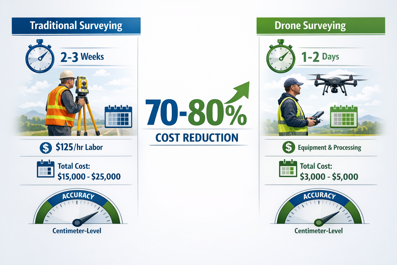
- 💰 70-80% cost reduction: Drone surveys dramatically reduce labor costs compared to traditional methods at $125/hour, potentially saving major projects millions[1]
- 🤖 Autonomous capabilities: Push-button automation and predictive modeling enable single-flight comprehensive data capture with minimal operator intervention[2][5]
- 📊 Multi-product output: One drone flight generates orthomosaic maps, 3D models, point clouds, contour maps, and cut/fill reports simultaneously[1][3]
Understanding the Fundamentals of Drone Surveying for Property Projects
What Makes Drone Surveying Different in 2026
The landscape of aerial surveying has transformed dramatically. Unlike earlier iterations that simply replaced manned aircraft with unmanned alternatives, modern drone surveying systems integrate advanced technologies that fundamentally change the surveying workflow.
LiDAR (Light Detection and Ranging) equipped drones now capture centimeter-resolution imagery even through thick vegetation, enabling accurate elevation and boundary mapping in challenging terrain where traditional ground-based methods struggle[6]. This penetration capability represents a quantum leap beyond photogrammetry-only solutions.
The three core requirements that define successful drone surveying in 2026 are[5]:
- Fast results – Actionable data within hours, not days
- Survey-grade accuracy – Sub-5cm precision for professional applications
- Minimal operator intervention – Push-button simplicity over complex workflows
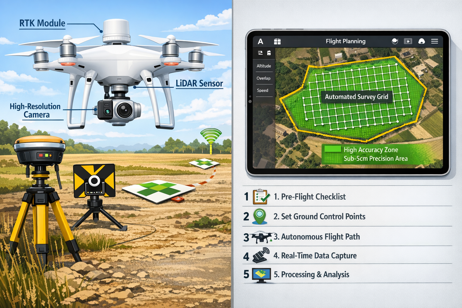
The Technology Stack: Hardware and Software Integration
Modern drone surveying relies on an integrated ecosystem of hardware and software components working in harmony:
Hardware Components:
- RTK/PPK-enabled drones – Real-Time Kinematic positioning for centimeter-level accuracy
- High-resolution cameras – Capturing detailed imagery for photogrammetric processing
- LiDAR sensors – Laser scanning for vegetation penetration and precise elevation data
- Ground Control Points (GCPs) – Physical markers for georeferencing and accuracy verification
Software Solutions:
Professional drone surveying platforms now emphasize fully automatic project tiling, distributed processing, and out-of-the-box camera calibration for the newest sensors. The emerging standard is straightforward: drop the drone images into the software, click Process, and return to final, production-ready deliverables with virtually zero manual intervention[5].
Data Products Generated from Single Flights
One of the most compelling advantages of modern drone surveying is the comprehensive data output from a single flight mission[1][3]:
| Data Product | Application | Typical Accuracy |
|---|---|---|
| Orthomosaic Maps | Site overview, progress tracking | 2-5cm GSD |
| 3D Terrain Models | Volumetric analysis, visualization | Sub-5cm vertical |
| Point Clouds | Detailed surface modeling | Millions of points |
| Contour Maps | Elevation analysis, drainage planning | 5-10cm intervals |
| Cut/Fill Reports | Earthwork verification, cost estimation | ±2-3cm accuracy |
| High-res Progress Photos | Documentation, stakeholder communication | 1-2cm GSD |
This multi-product capability transforms the value proposition. Rather than commissioning separate surveys for different purposes, a single drone flight provides the foundation for multiple analytical workflows.
Step-by-Step Guide to Implementing Drone Surveying Mastery
Phase 1: Pre-Flight Planning and Preparation
Successful drone surveying begins long before takeoff. Proper planning ensures accuracy, regulatory compliance, and efficient data capture.
1. Define Project Objectives and Requirements
Start by clarifying exactly what data products the project requires. Different applications demand different approaches:
- Boundary surveys require high horizontal accuracy and clear edge definition
- Volumetric analysis prioritizes vertical accuracy and complete coverage
- Progress monitoring needs consistent flight parameters for temporal comparison
- As-built documentation requires comprehensive detail and georeferencing
Understanding these requirements helps determine flight altitude, overlap percentages, and sensor selection.
2. Site Assessment and Risk Analysis
Conduct a thorough site evaluation before deploying equipment:
✅ Identify obstacles – Power lines, towers, trees, and structures that affect flight paths
✅ Assess terrain variability – Steep slopes may require adjusted flight parameters
✅ Evaluate vegetation – Dense canopy may necessitate LiDAR over photogrammetry
✅ Check connectivity – Ensure adequate GPS/GNSS signal strength
✅ Weather monitoring – Wind speeds, precipitation, and lighting conditions
3. Regulatory Compliance for 2026
The regulatory framework governing drone operations continues to evolve. In 2026, operators must ensure:
- Valid operator certification – Commercial drone pilot license appropriate to jurisdiction
- Flight permissions – Airspace authorization for the specific location and altitude
- Privacy compliance – Adherence to data protection regulations when capturing imagery
- Insurance requirements – Adequate liability coverage for commercial operations
- Notification protocols – Informing relevant authorities and adjacent property owners
Professional property surveyors increasingly incorporate these regulatory considerations into their standard workflows.
4. Ground Control Point Placement
For survey-grade accuracy, strategically placed Ground Control Points (GCPs) are essential:
Best practices for GCP deployment:
- Position GCPs evenly across the survey area, including perimeter locations
- Use highly visible markers (checkerboard patterns or specialized targets)
- Survey GCP coordinates using RTK GPS or total station equipment
- Document each GCP with photographs and coordinate records
- Plan for 3-5 GCPs per 100 acres as a baseline, adjusting for terrain complexity
Pro Tip: Even with RTK-enabled drones, GCPs serve as valuable checkpoints to verify accuracy and identify systematic errors in the data.
Phase 2: Flight Execution and Data Capture
5. Flight Planning Software Configuration
Modern flight planning applications automate much of the complexity, but understanding key parameters ensures optimal results:
Critical flight parameters:
- Altitude: Higher altitude = faster coverage but lower resolution; 100-120m typical for large sites
- Overlap: 70-80% front overlap and 60-70% side overlap ensures sufficient tie points
- Speed: Slower speeds reduce motion blur; 5-8 m/s typical for mapping missions
- Camera angle: Nadir (straight down) for orthomosaics; oblique angles for 3D modeling
- Lighting: Midday sun minimizes shadows; consistent conditions across flights
The software generates an automated flight path that the drone follows autonomously, capturing images at predetermined intervals.
6. Autonomous Flight Execution
A defining characteristic of 2026 drone surveying is the autonomous capability that enables drones to automatically adjust altitude, angle, and sensor selection based on predictive modeling[2]. This allows what previously required multiple site visits to be captured in a single, highly detailed flight.
During flight execution:
- Monitor battery levels and plan for battery swaps on large sites
- Track real-time GPS accuracy indicators
- Verify image capture confirmation for each waypoint
- Document any anomalies or deviations from planned flight path
- Maintain visual line of sight or utilize appropriate beyond visual line of sight (BVLOS) authorizations
Drones can cover acres of land within several hours compared to days or weeks with traditional manual surveying, with complete surveys often achievable in less than an hour[1][6].
7. Data Quality Verification
Before leaving the site, perform preliminary quality checks:
- Review image count against expected number based on flight plan
- Spot-check image sharpness and exposure
- Verify GCP visibility in captured imagery
- Confirm GPS metadata embedded in image files
- Document site conditions and any notable circumstances
This on-site verification prevents costly return trips to recapture missing or inadequate data.
Phase 3: Data Processing and Deliverable Generation
8. Photogrammetric Processing Workflow
The 2026 development roadmap emphasizes fully automatic project tiling, distributed processing, and out-of-the-box camera calibration for newest sensors[5]. Leading platforms like DroneDeploy can cut documentation time in half while ensuring data consistency across project phases[3].
Standard processing workflow:
- Import images – Load captured imagery and associated metadata
- Add GCPs – Mark ground control points in multiple images for georeferencing
- Initial processing – Software generates tie points and camera positions
- Quality review – Check alignment quality and camera position accuracy
- Dense reconstruction – Generate detailed point cloud from imagery
- Surface generation – Create Digital Surface Model (DSM) and Digital Terrain Model (DTM)
- Orthomosaic creation – Produce geometrically corrected, seamless map
- Export deliverables – Generate required outputs in client-specified formats
Processing time varies with project size and hardware capabilities, but modern systems deliver finished products within hours after the last photo is captured—the absolute minimum requirement in 2026[5].
9. Accuracy Verification and Quality Control
Professional surveying demands rigorous quality control. Verify accuracy through:
- Checkpoint analysis – Compare known coordinates to model-derived coordinates
- Statistical reporting – Calculate Root Mean Square Error (RMSE) for horizontal and vertical accuracy
- Visual inspection – Review orthomosaic for distortions, gaps, or artifacts
- Cross-section validation – Compare elevation profiles to known benchmarks
RTK-enabled drones deliver sub-5cm precision for orthomosaic maps, essential for verifying earthwork, slab elevation, and utility placement on large-scale projects[3].
ROI Analysis: Drone Surveying vs. Traditional Methods
Cost Comparison Framework
Understanding the return on investment for drone surveying adoption requires comprehensive cost analysis across multiple dimensions.
Traditional Surveying Costs:
Traditional surveying methods cost approximately $125/hour in labor alone, plus extensive office processing time[1]. For a large-scale property project, typical costs include:
- Field crew (2-3 surveyors): $125-$175/hour × 40-120 hours = $5,000-$21,000
- Equipment rental/depreciation: $500-$1,500
- Office processing and CAD work: $75-$100/hour × 20-40 hours = $1,500-$4,000
- Total traditional survey cost: $7,000-$26,500
Drone Surveying Costs:
- Drone operator: $100-$150/hour × 4-8 hours = $400-$1,200
- Equipment (owned or rented): $500-$2,000 per project
- Software licensing: $200-$500 per project
- Processing and deliverable generation: $500-$1,500
- Total drone survey cost: $1,600-$5,200
Quantifiable Benefits Beyond Direct Cost Savings
The financial advantages extend well beyond simple cost reduction:
Time Savings:
Complete surveys achievable in less than an hour with data turnaround within 24 hours[1][6] versus weeks for traditional methods. For time-sensitive projects, this acceleration can save:
- Reduced project delays: $5,000-$50,000+ depending on project scale
- Faster decision-making: Enabling earlier issue identification and resolution
- Compressed project timelines: Reducing financing costs and accelerating revenue
Accuracy-Driven Savings:
Centimeter-level precision enables accurate estimations and data-driven decisions, potentially saving major civil construction projects millions of dollars[1] through:
- Precise cut/fill calculations reducing material waste
- Accurate as-built documentation preventing rework
- Early detection of grading errors before concrete placement
- Optimized drainage design based on precise elevation data
Enhanced Safety:
Drone surveying eliminates the need for surveyors to access hazardous areas:
- Reduced worker exposure to traffic, unstable slopes, or contaminated sites
- Lower insurance premiums and workers' compensation costs
- Decreased liability exposure from surveying-related incidents
Real-World ROI Calculation Example
Large-Scale Property Development Project:
500-acre mixed-use development requiring monthly progress monitoring over 24-month construction period
| Cost Category | Traditional Method | Drone Method | Savings |
|---|---|---|---|
| Initial survey | $22,000 | $4,500 | $17,500 |
| Monthly monitoring (24×) | $288,000 | $96,000 | $192,000 |
| As-built documentation | $28,000 | $5,000 | $23,000 |
| Rework from inaccurate data | $150,000 | $15,000 | $135,000 |
| Total | $488,000 | $120,500 | $367,500 |
ROI: 305% – For every dollar invested in drone surveying infrastructure and services, the project saves $3.05 in direct and indirect costs.
For professionals evaluating surveying options, understanding topographic survey costs provides essential context for these comparisons.
Advanced Best Practices for Large-Scale Property Projects
Implementing Continuous Monitoring Workflows
Construction and surveying workflows in 2026 now incorporate weekly or even daily drone flights that automatically convert site conditions into actionable insights, moving from infrequent satellite updates to continuous monitoring with real-time accuracy[3].
Benefits of high-frequency monitoring:
📊 Progress tracking – Quantifiable measurement of work completed versus scheduled
🚧 Issue identification – Early detection of grading errors, drainage problems, or encroachments
📈 Stakeholder communication – Visual documentation for clients, investors, and regulators
💡 Predictive analytics – Trend analysis enabling proactive project management
Integrating Drone Data with BIM and GIS Systems
The true power of drone surveying emerges when spatial data integrates seamlessly with broader project management systems:
Building Information Modeling (BIM) Integration:
- Import accurate as-built terrain models into BIM platforms
- Verify constructed elements against design specifications
- Enable clash detection between design and existing conditions
- Support 4D scheduling visualization with actual site progress
Geographic Information Systems (GIS) Integration:
- Layer drone-derived data with property boundaries, utilities, and zoning
- Conduct spatial analysis for site suitability and environmental impact
- Create comprehensive asset management databases
- Enable long-term monitoring and change detection
Multi-Sensor Fusion Strategies
Sophisticated projects benefit from combining multiple sensor technologies:
Photogrammetry + LiDAR Combination:
- LiDAR penetrates vegetation for accurate ground elevation
- Photogrammetry provides high-resolution visual texture and color
- Combined output delivers both geometric accuracy and visual detail
- Particularly valuable for partially vegetated sites
Thermal + Visual Imaging:
- Thermal sensors identify moisture intrusion, heat loss, or subsurface features
- Visual imagery provides context and detailed documentation
- Combined analysis supports building envelope assessment and utility mapping
Establishing Data Management Protocols
As drone surveying becomes routine, robust data management becomes critical:
Essential protocols include:
- Standardized file naming conventions for images, models, and deliverables
- Version control systems tracking changes across survey iterations
- Secure cloud storage with appropriate access controls and backup redundancy
- Metadata documentation recording flight parameters, processing settings, and accuracy metrics
- Archive strategies balancing accessibility with storage costs
Similar to how professionals approach monitoring surveys, systematic data management ensures long-term value and defensibility.
Selecting Affordable UAV Systems for Land Management
Evaluating Drone Platforms for Survey Applications
The drone market offers numerous options across a wide price spectrum. Selecting the appropriate platform requires balancing capability, cost, and project requirements.
Entry-Level Survey Drones ($1,500-$5,000):
Platforms like the DJI Mavic 3 series offer:
- High-resolution cameras (20MP+)
- Adequate positioning accuracy for general mapping
- Portable form factor for easy deployment
- Limited battery life (25-35 minutes)
- Best for: Small properties, preliminary assessments, visual documentation
Mid-Range Survey Drones ($5,000-$15,000):
Platforms like the DJI Phantom 4 RTK provide:
- RTK positioning for centimeter-level accuracy
- Specialized mapping cameras with mechanical shutters
- Extended flight time (30-40 minutes)
- Integrated flight planning and processing software
- Best for: Most topographic surveying applications, construction monitoring
Professional Survey Drones ($15,000-$50,000+):
Platforms like the DJI Matrice 300 RTK or specialized mapping drones offer:
- Interchangeable payload capabilities (LiDAR, multispectral, thermal)
- Extended flight time (45-55 minutes)
- Advanced obstacle avoidance and safety features
- Enterprise-grade reliability and support
- Best for: Large-scale projects, challenging environments, multi-sensor applications
LiDAR vs. Photogrammetry: Choosing the Right Technology
Understanding when to deploy each technology optimizes both cost and results:
Choose Photogrammetry When:
- Site has minimal vegetation or clear ground visibility
- Visual texture and color information are important
- Budget constraints favor lower equipment costs
- Processing infrastructure supports intensive computation
Choose LiDAR When:
- Dense vegetation obscures ground surface
- Vertical structures require precise measurement
- Consistent accuracy needed regardless of lighting conditions
- Underground utility mapping or subsurface feature detection required
Consider Hybrid Approaches When:
- Project scope justifies investment in both technologies
- Different site areas have varying characteristics
- Comprehensive data requirements span multiple applications
Software Selection and Licensing Models
Processing software represents a significant component of total cost of ownership. In 2026, several licensing models prevail:
Subscription-Based Platforms:
- Monthly or annual fees ($150-$500/month)
- Regular updates and new features
- Cloud processing reduces local hardware requirements
- Scalable based on project volume
Perpetual License Software:
- One-time purchase ($3,000-$15,000)
- Ongoing maintenance fees for updates
- Local processing requires powerful workstations
- Predictable long-term costs for high-volume users
Pay-Per-Project Services:
- Process individual projects on-demand ($50-$500 per project)
- No software expertise required
- Variable costs based on usage
- Limited customization and control
Regulatory Compliance and 2026 Updates
UK Drone Regulations for Commercial Surveying
Operating drones commercially in the UK requires adherence to Civil Aviation Authority (CAA) regulations:
Operator Requirements:
- Flyer ID: Free online test demonstrating basic drone knowledge
- Operator ID: Registration for anyone responsible for drone operations (£10.33 annually)
- Commercial Pilot License: GVC (General VLOS Certificate) for commercial operations
- Operational Authorization: Permission for specific operations beyond standard limitations
Flight Restrictions:
- Maximum altitude: 120m (400 feet) above ground level
- Visual line of sight (VLOS) maintained unless specific authorization granted
- Minimum distances from people, vehicles, and structures based on drone category
- Restricted zones around airports, military installations, and sensitive areas
Privacy and Data Protection Considerations
Drone surveying captures extensive visual data, raising important privacy considerations:
GDPR Compliance:
When surveying captures identifiable individuals or private property:
- Conduct Data Protection Impact Assessments (DPIA) for projects
- Implement data minimization principles (capture only necessary data)
- Establish secure data handling and storage protocols
- Provide transparency about data collection to affected parties
Best Practices:
- Schedule flights during off-peak hours to minimize incidental capture of people
- Blur or redact identifiable individuals in published imagery
- Notify adjacent property owners when surveying near boundaries
- Maintain detailed records of data collection, processing, and retention
Insurance and Liability Management
Adequate insurance protection is essential for commercial drone operations:
Required Coverage:
- Public Liability Insurance: £1-5 million coverage typical for surveying operations
- Equipment Insurance: Protecting drone hardware investment
- Professional Indemnity: Covering errors or omissions in survey deliverables
- Employer's Liability: If operating with employees or subcontractors
Professional chartered surveyors typically maintain comprehensive insurance portfolios covering both traditional and drone-based surveying activities.
Common Challenges and Solutions in Drone Surveying Mastery

Challenge 1: Achieving Consistent Accuracy Across Large Sites
Problem: Maintaining survey-grade accuracy over hundreds of acres with variable terrain and GPS conditions.
Solutions:
✅ Deploy adequate GCP density, increasing concentration in areas of terrain complexity
✅ Use RTK/PPK drones to reduce GCP dependency
✅ Conduct multiple overlapping flights rather than pushing range limits
✅ Verify accuracy with independent checkpoints before finalizing deliverables
✅ Process data in manageable sections, then merge with controlled alignment
Challenge 2: Managing Data Volume and Processing Time
Problem: Large projects generate hundreds of gigabytes of imagery requiring substantial processing resources.
Solutions:
✅ Invest in high-performance workstations with adequate RAM (64GB+) and GPU acceleration
✅ Utilize cloud processing services for distributed computation
✅ Implement automated workflows that process data overnight
✅ Archive raw data to network storage while maintaining processed deliverables locally
✅ Optimize flight parameters to balance coverage with data volume
Challenge 3: Weather and Environmental Limitations
Problem: Wind, precipitation, and lighting conditions restrict flight operations.
Solutions:
✅ Schedule flights during optimal weather windows (early morning often ideal)
✅ Monitor weather forecasts and maintain flexible scheduling
✅ Use wind-resistant platforms for challenging conditions
✅ Implement multiple smaller flights rather than single extended missions
✅ Develop contingency plans for weather-related delays
Challenge 4: Regulatory Navigation and Airspace Restrictions
Problem: Complex airspace regulations and authorization requirements delay projects.
Solutions:
✅ Conduct airspace research during project planning phase
✅ Submit authorization requests well in advance of required flight dates
✅ Establish relationships with local aviation authorities
✅ Maintain comprehensive documentation of permissions and notifications
✅ Consider alternative survey methods for severely restricted areas
Challenge 5: Client Education and Expectation Management
Problem: Clients unfamiliar with drone surveying may have unrealistic expectations or concerns.
Solutions:
✅ Provide clear explanations of capabilities and limitations
✅ Share sample deliverables and accuracy specifications
✅ Establish realistic timelines accounting for weather and processing
✅ Demonstrate value through pilot projects or case studies
✅ Maintain transparent communication throughout project lifecycle
Future Trends: What's Next for Drone Surveying Beyond 2026
Artificial Intelligence and Machine Learning Integration
The next evolution in drone surveying involves AI-powered analysis that extracts actionable intelligence automatically:
Emerging capabilities:
- Automated feature extraction (buildings, roads, utilities, vegetation)
- Change detection comparing sequential surveys without manual analysis
- Predictive modeling identifying potential issues before they manifest
- Quality control algorithms flagging data anomalies automatically
Swarm Technology and Coordinated Multi-Drone Operations
Advanced projects will deploy multiple drones simultaneously, each optimized for specific tasks:
- Coordinated coverage reducing total flight time
- Specialized sensors on different platforms (visual, LiDAR, thermal)
- Automated handoff between drones as batteries deplete
- Real-time data fusion from multiple simultaneous sources
Enhanced Autonomy and Reduced Operator Requirements
The trajectory toward full autonomy continues, with systems requiring minimal human intervention:
- Automated mission planning based on project objectives and site characteristics
- Self-optimizing flight parameters adapting to real-time conditions
- Autonomous obstacle avoidance enabling complex environment navigation
- Automated quality assessment and re-flight triggering when needed
Integration with Digital Twin Ecosystems
Drone surveying will become foundational to digital twin creation and maintenance:
- Continuous data feeds updating virtual representations of physical assets
- Real-time synchronization between physical construction and digital models
- Predictive simulation using actual site conditions
- Lifecycle asset management from construction through operation
Conclusion: Achieving Drone Surveying Mastery in 2026
Drone Surveying Mastery: Best Practices for Accurate Topographic Mapping in Large-Scale Property Projects represents more than technological adoption—it requires fundamental transformation in how surveying professionals approach spatial data collection, processing, and analysis.
The evidence is compelling: drone surveying delivers 70-80% cost reductions, sub-5cm accuracy, and hour-scale turnaround times that traditional methods cannot match[1][3][6]. The technology has matured from experimental to essential, with the market exceeding $6.5 billion in 2026[9] as organizations recognize the competitive necessity of aerial intelligence.
Actionable Next Steps for Implementation
For Organizations Beginning Drone Surveying:
- Start with pilot projects – Test capabilities on smaller properties before scaling
- Invest in training – Ensure operators achieve proper certification and develop processing expertise
- Select appropriate technology – Match drone and software capabilities to project requirements
- Establish workflows – Develop standardized procedures for data capture, processing, and quality control
- Build partnerships – Consider outsourcing initially while developing internal capabilities
For Organizations Scaling Existing Programs:
- Automate workflows – Implement push-button processing and standardized deliverable generation
- Expand capabilities – Add LiDAR, thermal, or multispectral sensors for specialized applications
- Integrate systems – Connect drone data with BIM, GIS, and project management platforms
- Develop analytics – Move beyond basic mapping to predictive intelligence and automated analysis
- Measure ROI – Track cost savings, time reduction, and accuracy improvements systematically
For Property Professionals Evaluating Options:
When commissioning topographic surveys for large-scale projects, consider:
- Requesting drone-based proposals alongside traditional methods for comparison
- Specifying required accuracy levels and deliverable formats clearly
- Understanding the value of continuous monitoring versus one-time surveys
- Evaluating provider capabilities in both data capture and analysis
- Considering long-term data management and accessibility requirements
The transformation of surveying through drone technology mirrors broader digital transformation across the construction and property sectors. Organizations that master these capabilities position themselves for competitive advantage, operational efficiency, and enhanced decision-making that drives project success.
The future of topographic mapping has arrived. The question is not whether to adopt drone surveying, but how quickly your organization can achieve mastery and realize the substantial benefits this technology delivers.
For professional guidance on implementing drone surveying solutions or understanding how aerial intelligence can enhance your specific project requirements, consult with experienced drone survey specialists who can tailor approaches to your unique needs and objectives.
References
[1] Drones Changing The Game For Topographic Surveying – https://www.propelleraero.com/blog/drones-changing-the-game-for-topographic-surveying/
[2] Future Land Surveying 2026 – https://haller-blanchard.com/future-land-surveying-2026/
[3] The Rise Of Drone Mapping In Construction Speed Accuracy And Efficiency From The Sky – https://www.dronedeploy.com/blog/the-rise-of-drone-mapping-in-construction-speed-accuracy-and-efficiency-from-the-sky
[5] Drone Mapping Trends 2026 Simactive – https://dronelife.com/2025/12/03/drone-mapping-trends-2026-simactive/
[6] Drone Topographic Survey Cost Complete Pricing Guide For 2026 – https://dronelidarmapping.com/drone-topographic-survey-cost-complete-pricing-guide-for-2026/
[8] Drone Survey Operations Drive Scalable Growth In Drones As A Service Daas 1035790159 – https://markets.businessinsider.com/news/stocks/drone-survey-operations-drive-scalable-growth-in-drones-as-a-service-daas-1035790159
[9] Aerial Survey Companies – https://www.extremeaerialproductions.com/post/aerial-survey-companies