
The modern surveyor faces an unprecedented challenge: managing vast quantities of spatial data from multiple sources while delivering actionable insights to clients under tight deadlines. Traditional methods of juggling paper maps, spreadsheets, and disconnected databases are no longer sufficient in 2026's fast-paced development environment. GIS Integration for Surveyors: Overlaying Data for Smarter Land Management Decisions represents a fundamental shift in how professionals approach land analysis, combining zoning regulations, utility networks, property boundaries, and environmental constraints into unified, interactive digital maps that transform raw data into strategic intelligence.
This comprehensive guide explores how Geographic Information Systems (GIS) technology empowers surveyors to create sophisticated data overlays that streamline development projects, reduce compliance risks, and accelerate decision-making processes. From understanding core integration concepts to implementing advanced workflows with drone technology and artificial intelligence, this article provides the knowledge needed to leverage GIS for competitive advantage in land management.
Key Takeaways
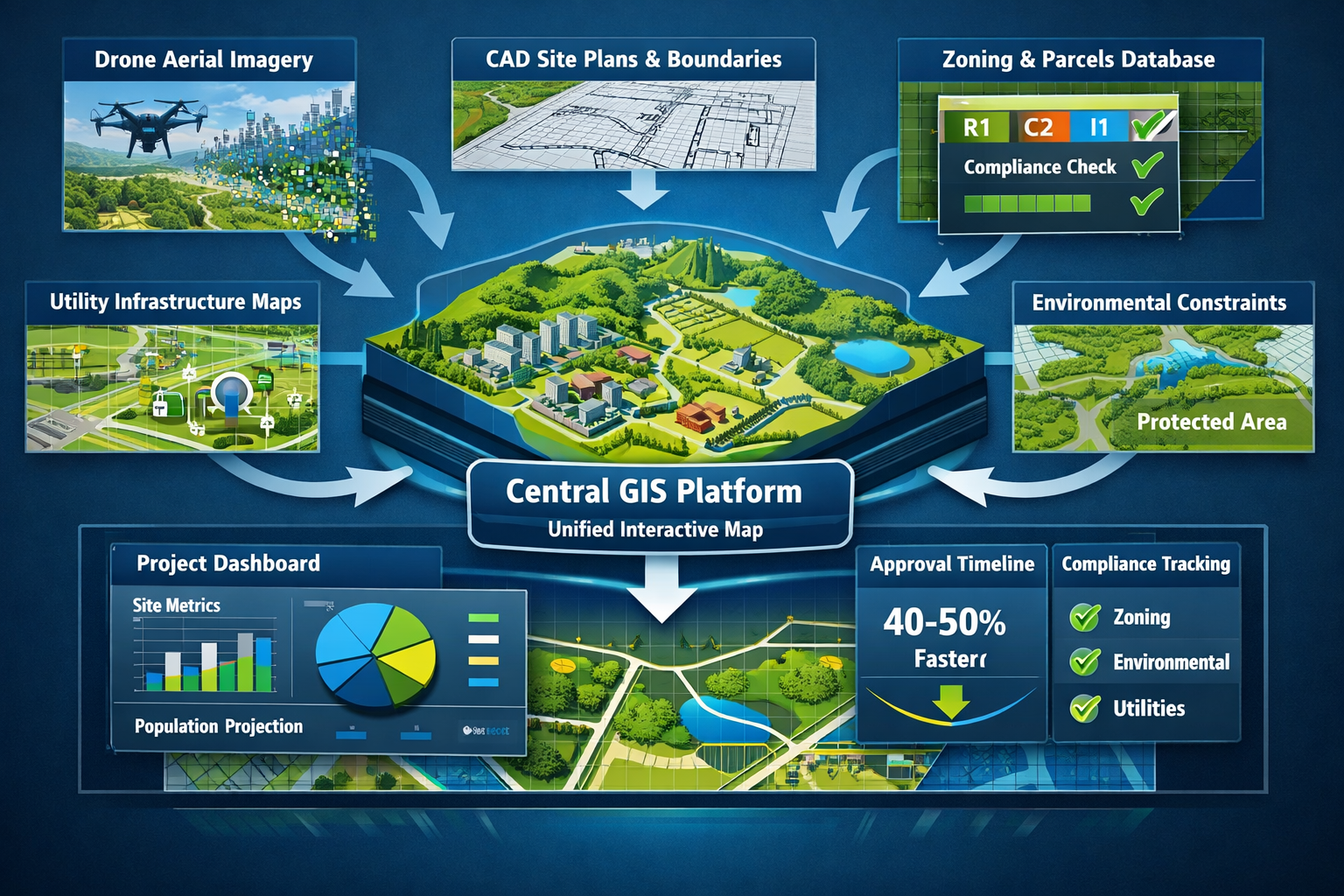
- GIS integration enables surveyors to combine multiple datasets—including zoning information, property boundaries, utility locations, and topographic features—into single, interactive maps that enhance analysis and planning capabilities
- Real-time GIS dashboards reduce approval and verification timelines by 40-50% while lowering administrative costs by 20-30% through automation and streamlined workflows[4]
- Built-in compliance tracking reduces zoning and regulatory issues by up to 25%, helping surveyors identify potential conflicts before they become costly problems[4]
- Drone integration with GIS workflows eliminates data transfer bottlenecks, enabling faster field-to-analysis cycles and more efficient project delivery[3]
- Cloud-based geospatial platforms and emerging technologies like GeoAI and digital twins are transforming how surveyors collect, process, and share spatial information with stakeholders
Understanding GIS Integration Fundamentals for Land Surveyors

Geographic Information Systems represent far more than digital mapping software. At their core, GIS platforms provide surveyors with powerful tools to capture, store, analyze, and visualize spatial data in ways that reveal patterns and relationships invisible in traditional survey deliverables.
What Makes GIS Integration Essential in 2026
The surveying profession has evolved dramatically from its roots in simple boundary determination. Today's surveyors serve as spatial data consultants, providing insights that inform critical development decisions worth millions of dollars. GIS integration addresses several fundamental challenges:
Data Fragmentation: Property information typically exists across multiple disconnected systems—municipal zoning databases, utility company records, environmental agency datasets, and private survey archives. GIS provides a unified platform where these disparate sources converge into coherent, analyzable formats.
Visualization Complexity: Stakeholders struggle to interpret technical survey data presented in traditional formats. GIS transforms complex spatial relationships into intuitive visual representations that non-technical decision-makers can understand and act upon.
Analysis Limitations: Paper maps and CAD drawings offer static snapshots of conditions. GIS enables dynamic analysis—measuring distances, calculating areas, identifying overlaps, and modeling scenarios in real-time.
Collaboration Barriers: Development projects involve multiple parties who need access to current information. Cloud-based GIS platforms facilitate real-time data sharing that keeps all stakeholders synchronized[3].
Core GIS Capabilities That Transform Survey Practice
Modern GIS platforms deliver capabilities specifically valuable for surveying applications:
🗺️ Multi-Layer Data Overlay: The ability to stack and visualize multiple datasets simultaneously represents GIS's most transformative feature. Surveyors can overlay property boundaries atop zoning districts, utility easements, flood zones, soil classifications, and topographic contours—revealing spatial relationships that inform development feasibility[1].
📊 Spatial Analysis Tools: Built-in functions calculate buffer zones around features, identify parcels within specific distances of infrastructure, measure slope and aspect for drainage planning, and perform viewshed analysis for site planning.
🔍 Attribute Querying: GIS links spatial features to detailed attribute databases. Clicking a parcel reveals ownership history, assessed values, zoning classifications, permitted uses, and development restrictions—information critical for due diligence.
📱 Mobile Data Collection: Field crews equipped with GPS-enabled tablets capture survey observations directly into GIS databases, eliminating transcription errors and accelerating data availability.
🔄 Automated Updates: When connected to authoritative data sources, GIS maps automatically reflect changes in zoning regulations, utility infrastructure, or environmental designations—ensuring surveyors work with current information.
For professionals seeking to verify their technical capabilities in these advanced methodologies, understanding how to verify surveyor credentials in the UK ensures clients receive services from qualified practitioners.
Building Effective Data Overlay Systems for Development Projects
Creating meaningful GIS overlays requires strategic thinking about which datasets to combine and how to structure them for analysis. GIS Integration for Surveyors: Overlaying Data for Smarter Land Management Decisions succeeds when practitioners follow systematic approaches to data selection, preparation, and integration.
Identifying Critical Data Layers for Land Management
Effective overlay systems begin with identifying the specific datasets relevant to project objectives. While every development presents unique requirements, certain data categories prove consistently valuable:
Regulatory and Administrative Layers:
- Zoning districts with permitted use classifications
- Overlay zones (historic districts, design review areas, special permits)
- Setback requirements and building envelopes
- Comprehensive plan designations
- Jurisdictional boundaries
Infrastructure and Utilities:
- Water distribution networks (mains, services, valves, hydrants)
- Sanitary sewer systems (gravity lines, force mains, pump stations)
- Storm drainage infrastructure (pipes, inlets, detention facilities)
- Electrical distribution (overhead and underground)
- Natural gas pipelines
- Telecommunications networks
- Transportation systems (roads, sidewalks, bike paths)
Property and Ownership:
- Parcel boundaries with legal descriptions
- Easements (utility, access, conservation, drainage)
- Rights-of-way (public and private)
- Deed restrictions and covenants
- Survey monuments and control points
Environmental and Physical:
- Topographic contours and digital elevation models
- Floodplain boundaries (100-year, 500-year)
- Wetlands and waterbodies
- Soil classifications and bearing capacities
- Vegetation and tree canopy
- Endangered species habitats
- Geologic hazards (landslide zones, seismic faults)
Development Context:
- Existing structures and improvements
- Adjacent development projects
- Historical aerial imagery
- Current satellite or drone imagery
- Site photographs with GPS coordinates
Data Acquisition and Quality Assurance Strategies
The value of GIS overlays depends entirely on data quality. Surveyors must establish rigorous processes for acquiring and validating spatial information:
| Data Source | Typical Providers | Quality Considerations |
|---|---|---|
| Parcel Boundaries | County assessor, recorder offices | Verify survey accuracy, check for boundary disputes, confirm legal descriptions match |
| Zoning Information | Municipal planning departments | Ensure current regulations, verify effective dates, check for pending changes |
| Utility Networks | Individual utility companies | Request as-built records, verify age of data, field-verify critical features |
| Topography | USGS, LiDAR surveys, drone mapping | Check contour interval, verify datum and projection, assess currency |
| Environmental Data | FEMA, EPA, state agencies | Confirm regulatory status, verify mapping methods, check update frequency |
Best Practices for Data Integration:
- Standardize Coordinate Systems: Convert all datasets to a common projection and datum before overlay analysis to ensure spatial alignment
- Document Data Lineage: Maintain metadata recording source, acquisition date, accuracy specifications, and contact information for each layer
- Implement Version Control: Track dataset updates and maintain historical versions to support change analysis
- Validate Spatial Accuracy: Field-verify critical features using GPS or total station measurements, especially at layer intersections
- Establish Update Schedules: Create protocols for refreshing dynamic datasets (utilities, zoning) while preserving static baseline information
The types of surveyors and their specializations often determine which data layers receive priority attention, with land surveyors focusing on boundaries and easements while engineering surveyors emphasize infrastructure and topography.
Creating Meaningful Overlay Combinations
The true power of GIS emerges when surveyors combine layers strategically to answer specific questions. Rather than displaying all available data simultaneously—which creates visual confusion—effective practitioners build targeted overlay sets for particular analyses:
Development Feasibility Analysis:
- Base: Current zoning with permitted uses
- Overlay 1: Property boundaries with ownership
- Overlay 2: Utility availability (water, sewer capacity)
- Overlay 3: Environmental constraints (wetlands, floodplains)
- Overlay 4: Access and circulation (roads, easements)
Utility Conflict Identification:
- Base: Proposed development footprint
- Overlay 1: Existing underground utilities (all types)
- Overlay 2: Utility easements and rights-of-way
- Overlay 3: Proposed grading and excavation depths
- Overlay 4: Setback requirements from utilities
Compliance Verification:
- Base: Site plan with proposed improvements
- Overlay 1: Zoning setbacks and building envelopes
- Overlay 2: Overlay district requirements
- Overlay 3: Easement restrictions
- Overlay 4: Environmental buffer zones
Site Selection Analysis:
- Base: Study area with candidate parcels
- Overlay 1: Zoning compatibility scoring
- Overlay 2: Utility proximity and capacity
- Overlay 3: Transportation access metrics
- Overlay 4: Environmental sensitivity rankings
"GIS enables surveyors to overlay multiple datasets—including zoning information, boundaries, and utility locations—into single, integrated maps. This centralization enhances data management, pattern identification in land use trends, and informed decision-making through easy-to-understand visualizations."[1]
Implementing GIS Integration for Smarter Land Management Decisions
Moving from conceptual understanding to practical implementation requires selecting appropriate technology platforms, establishing efficient workflows, and developing skills to extract maximum value from integrated spatial data. GIS Integration for Surveyors: Overlaying Data for Smarter Land Management Decisions becomes operational through systematic deployment strategies.
Selecting GIS Platforms and Tools for Survey Applications
The GIS marketplace offers solutions ranging from enterprise-level platforms to specialized surveying software. Selection criteria should align with practice size, project types, technical capabilities, and budget constraints:
Enterprise GIS Platforms:
Solutions like Esri's ArcGIS provide comprehensive capabilities for large firms handling complex multi-stakeholder projects. These platforms excel at:
- Managing large datasets across multiple projects
- Supporting simultaneous users with role-based access
- Integrating with enterprise databases and business systems
- Providing advanced spatial analysis and modeling tools
- Enabling web-based map services and public portals
Survey-Specific GIS Software:
Specialized products like Carlson GIS 2026 (available at $1,350.00)[7] offer surveying-focused functionality including:
- Direct integration with survey equipment and data collectors
- Coordinate geometry (COGO) tools familiar to surveyors
- CAD-like drafting capabilities with GIS intelligence
- Streamlined workflows for common surveying tasks
- Cost-effective licensing for smaller practices
Cloud-Based GIS Services:
Platforms leveraging Cloud Optimized GeoTIFF (COG) technology deliver faster loading times and smaller file sizes, making web-based applications more accessible[5]. These solutions offer:
- No local software installation or maintenance
- Automatic updates and feature enhancements
- Scalable storage and processing capacity
- Easy data sharing with clients and collaborators
- Subscription-based pricing models
Mobile GIS Applications:
Field data collection apps transform smartphones and tablets into powerful survey tools:
- GPS-enabled feature capture and attribute recording
- Offline functionality for remote locations
- Photo integration with automatic geotagging
- Real-time synchronization with office databases
- Form-based data entry ensuring consistency
Establishing Efficient GIS Workflows for Survey Projects
Successful GIS integration requires developing standardized workflows that move projects efficiently from field data collection through analysis to final deliverables:
Phase 1: Project Initiation and Data Gathering
- Define project objectives and analysis requirements
- Identify necessary data layers and acquisition sources
- Request data from agencies and utilities (allow 2-4 weeks)
- Establish project coordinate system and accuracy standards
- Create project workspace in GIS platform with folder structure
Phase 2: Data Preparation and Integration
- Import datasets and verify spatial alignment
- Standardize projections and convert units as needed
- Clean data (remove duplicates, fix topology errors)
- Validate critical features through field verification
- Build attribute databases and establish relationships
- Create symbology standards for consistent visualization
Phase 3: Field Survey and Data Collection
- Plan survey control network and establish monuments
- Configure mobile GIS apps with project layers and forms
- Conduct field surveys with GPS/total station equipment
- Capture features directly into GIS database
- Photograph site conditions with geotagged images
- Perform real-time quality checks against existing data
Phase 4: Analysis and Overlay Development
- Combine relevant layers for specific analyses
- Perform spatial queries and measurements
- Identify conflicts, constraints, and opportunities
- Generate buffer zones and proximity analyses
- Calculate areas, volumes, and quantities
- Create comparison scenarios for alternatives evaluation
Phase 5: Deliverable Production and Sharing
- Design map layouts with appropriate scales and legends
- Generate technical reports with embedded maps
- Export data in client-requested formats (PDF, DWG, SHP)
- Publish interactive web maps for stakeholder access
- Archive project data with complete metadata documentation
For projects requiring detailed structural analysis beyond basic surveying, integration with structural engineering services ensures comprehensive evaluation of proposed developments.
Leveraging Advanced Technologies in GIS Integration
The surveying profession in 2026 benefits from several emerging technologies that enhance GIS capabilities and expand service offerings:
Drone Integration for Rapid Data Capture:
Unmanned aerial systems (UAS) combined with GIS workflows are revolutionizing data collection efficiency. The Dudek company case study demonstrates practical benefits: integrating drones with GIS platforms like Site Scan for flight planning and processing eliminates time-consuming data transfer bottlenecks, with one surveyor noting "we weren't shipping hard drives around [the US], waiting for things to upload"[3].
Drone-GIS integration delivers:
- Rapid site coverage: Capture 100+ acres in single flights
- High-resolution imagery: 1-2 cm ground sampling distance
- Accurate elevation models: Generate digital terrain and surface models
- Volumetric calculations: Measure stockpiles and cut/fill quantities
- Change detection: Compare site conditions across time periods
- 3D modeling: Create photorealistic representations for visualization
Geospatial AI (GeoAI) for Automated Processing:
Artificial intelligence combined with GIS—termed GeoAI—enables automated data processing and predictive analysis. For land surveyors, GeoAI can extract key information from drone imagery and documents, supporting streamlined creation of planimetric data and image segmentation for integration with CAD and BIM systems[3].
GeoAI applications include:
- Automatic feature extraction (buildings, roads, utilities) from imagery
- Vegetation classification and tree inventory from multispectral data
- Pavement condition assessment from high-resolution photos
- Predictive modeling for development suitability analysis
- Anomaly detection identifying data quality issues
Digital Twin Technology:
ArcGIS GeoBIM combines GIS spatial analysis with 3D design and construction data to create dynamic virtual representations of built environments, allowing single-view data sharing and contextual understanding[3]. Digital twins enable:
- Real-time monitoring of construction progress against plans
- Integration of IoT sensor data (settlement, structural health)
- Scenario modeling for proposed changes
- Lifecycle asset management and maintenance planning
- Stakeholder visualization and public engagement
Real-Time Collaboration Platforms:
Companies are developing custom portals that combine GIS and CAD data for real-time sharing with staff and customers, supporting faster and more informed decision-making[3]. These platforms provide:
- Simultaneous multi-user access to current project data
- Comment and markup tools for collaborative review
- Automated notifications when data updates occur
- Role-based permissions controlling data access
- Mobile-responsive interfaces for field access
The integration of these technologies with traditional surveying practices represents the future of the profession, where qualified surveyors combine technical expertise with advanced digital capabilities.
Practical Applications Across Development Project Types
GIS Integration for Surveyors: Overlaying Data for Smarter Land Management Decisions delivers tangible benefits across diverse project categories. Understanding application-specific workflows helps surveyors tailor their GIS implementations to client needs.
Residential Development Projects
Residential developments—from single-family subdivisions to multi-unit complexes—benefit significantly from GIS overlay analysis that identifies constraints early in the planning process.
Critical Overlay Combinations:
Zoning Compliance Analysis: Overlay proposed lot layouts against zoning districts, density requirements, setback regulations, and open space mandates. GIS automatically calculates compliance metrics and highlights violations before expensive design work proceeds.
Utility Service Planning: Map existing water and sewer infrastructure capacity against proposed unit counts. Identify extension requirements, connection points, and potential capacity constraints requiring system upgrades.
Environmental Due Diligence: Combine wetland boundaries, floodplains, steep slopes, and protected species habitats to identify developable areas and required buffer zones. Calculate net buildable area after environmental exclusions.
Access and Circulation: Analyze road network capacity, sight distance requirements, emergency vehicle access, and pedestrian connectivity. Model traffic impacts on surrounding street systems.
Case Application: A 50-acre residential subdivision project used GIS overlays to identify a previously unmapped wetland that intersected proposed lots 12-18. By detecting this conflict during preliminary planning rather than after platting, the developer avoided costly redesign and regulatory delays, saving an estimated 6-8 months in project timeline.
For buyers evaluating properties in these developments, understanding whether a home survey is necessary helps them make informed decisions about property condition and boundaries.
Commercial and Industrial Site Development
Commercial projects involve complex utility requirements, traffic considerations, and regulatory compliance that GIS overlays help navigate efficiently.
Essential Analysis Layers:
Multi-Utility Coordination: Commercial developments require substantial utility infrastructure—high-capacity water and sewer, three-phase electrical service, natural gas, telecommunications, and often specialized systems. GIS overlays identify existing infrastructure capacity, required upgrades, and optimal routing for new services while avoiding conflicts with existing underground utilities.
Traffic Impact Analysis: Overlay proposed site access points against traffic count data, intersection capacity, sight distance requirements, and planned transportation improvements. Model trip generation impacts on surrounding road network.
Stormwater Management: Combine topographic data, soil infiltration rates, impervious surface calculations, and receiving water quality to design compliant stormwater systems. Model drainage patterns and identify detention facility locations.
Parking and Loading Analysis: Overlay building footprints, required parking ratios, loading dock requirements, and circulation patterns to optimize site layout. Verify compliance with minimum parking standards and accessibility requirements.
Operational Efficiency Gains: Real-time GIS dashboards are reducing approval and verification timelines by 40-50%, while automation and reduced paperwork lower administrative and operational expenses by 20-30% over time[4]. These efficiency improvements translate directly to reduced carrying costs and faster project delivery for commercial developers.
Infrastructure and Transportation Projects
Linear infrastructure projects—roads, utilities, pipelines—present unique challenges that GIS overlay analysis addresses effectively.
Critical Overlay Sets:
Corridor Analysis and Route Selection: Evaluate multiple alignment alternatives by overlaying environmental constraints (wetlands, streams, protected lands), property ownership (minimizing takings), existing utilities (avoiding conflicts), topography (minimizing earthwork), and cultural resources (avoiding archaeological sites).
Right-of-Way Requirements: Calculate precise property acquisition needs by overlaying proposed alignments with parcel boundaries. Generate preliminary title reports and identify potential condemnation requirements.
Utility Relocation Planning: Identify existing utilities within construction limits requiring relocation. Coordinate with utility owners and model temporary service impacts during construction.
Construction Phasing: Overlay traffic volumes, detour routes, and construction staging areas to develop phasing plans that maintain access while minimizing disruption.
The U.S. Department of Transportation released a GIS Strategic Plan for 2026-2030, with the Federal Highway Administration developing apps that alert project managers and field staff of incoming storms[9], demonstrating institutional adoption of GIS for infrastructure monitoring.
Agricultural and Rural Land Management
Precision agriculture and rural land management increasingly rely on GIS integration for resource optimization and regulatory compliance.
Key Overlay Applications:
Precision Agriculture: Combine soil test results, yield data, topography, and moisture sensors to create variable-rate application maps for fertilizers and pesticides. Monitor crop health through multispectral imagery analysis.
Conservation Planning: Overlay highly erodible land designations, riparian buffers, wetland reserve areas, and conservation easements to ensure compliance with USDA programs and maximize conservation payments.
Forest Management: Map timber stands, access roads, harvest units, and sensitive areas. Calculate sustainable yield and plan logging operations that minimize environmental impact.
Water Rights Management: Track irrigation systems, water sources, appropriation rights, and consumption against allocations. Model drought scenarios and optimize water distribution.
Environmental Conservation and Natural Resource Management
Environmental projects leverage GIS overlays to balance development pressures with conservation objectives.
Conservation Analysis Layers:
Habitat Connectivity: Identify wildlife corridors connecting protected areas. Prioritize land acquisition and conservation easements that maintain ecological connectivity.
Restoration Site Selection: Overlay degraded areas, ownership patterns, restoration potential, and funding eligibility to prioritize restoration investments.
EUDR Compliance: Swift Geospatial is expanding monitoring capabilities and European Union Deforestation Regulation (EUDR) support heading into 2026[8], enabling organizations to demonstrate sustainable sourcing through spatial tracking.
Disaster Risk Assessment: Combine wildfire risk, flood hazard, landslide susceptibility, and population density to identify high-risk areas requiring mitigation investments.
How land surveying and GIS collaborate across these diverse applications demonstrates the technology's versatility in addressing complex spatial challenges[2].
Overcoming Implementation Challenges and Maximizing ROI
While GIS integration offers substantial benefits, surveyors face practical challenges during implementation. Addressing these obstacles systematically ensures successful adoption and maximum return on investment.
Common Implementation Barriers
Technical Skill Gaps: Many surveyors trained in traditional methods lack GIS expertise. The software's complexity can intimidate practitioners accustomed to CAD-based workflows.
Solution Strategies:
- Invest in structured training programs (vendor courses, community colleges, online platforms)
- Start with basic functionality before advancing to complex analysis
- Designate a GIS champion within the firm to develop expertise and mentor others
- Partner with GIS specialists for initial projects until internal capabilities develop
- Utilize survey-specific GIS software with familiar interfaces
Data Acquisition Difficulties: Obtaining quality spatial data from agencies and utilities proves frustrating. Responses are slow, formats inconsistent, and accuracy questionable.
Solution Strategies:
- Build relationships with key data providers before urgent project needs arise
- Submit data requests early in project timelines (allow 4-6 weeks)
- Develop template request letters specifying required formats and accuracy
- Maintain a library of frequently-used datasets to reduce repeated requests
- Field-verify critical features rather than relying solely on provided data
- Consider purchasing commercial datasets for commonly-needed information
Software and Hardware Costs: Enterprise GIS platforms require significant investment in licenses, hardware, and ongoing maintenance.
Solution Strategies:
- Start with entry-level or survey-specific software (e.g., Carlson GIS at $1,350)[7]
- Utilize cloud-based platforms with subscription pricing to avoid large upfront costs
- Leverage free/open-source GIS software (QGIS) for basic applications
- Share licenses across multiple users through concurrent licensing models
- Calculate ROI based on efficiency gains and expanded service offerings
Integration with Existing Workflows: Incorporating GIS into established survey processes disrupts familiar routines and requires workflow redesign.
Solution Strategies:
- Implement gradually, starting with pilot projects in one service area
- Document new workflows with step-by-step procedures
- Maintain hybrid workflows during transition periods
- Demonstrate value through successful projects to build internal buy-in
- Integrate GIS with existing CAD and survey software through data exchange
Measuring Success and Demonstrating Value
Quantifying GIS benefits helps justify continued investment and expansion:
Efficiency Metrics:
- Project delivery time: Compare timeline from contract to deliverable before and after GIS implementation
- Revision cycles: Track reduction in plan revisions due to early conflict identification
- Field time: Measure decreased field hours through better planning and mobile data collection
- Data processing: Calculate time savings in data compilation and analysis
Quality Improvements:
- Error reduction: Document decrease in survey errors and omissions
- Compliance issues: Track reduction in regulatory conflicts (target: 25% improvement)[4]
- Client satisfaction: Survey clients on deliverable quality and usefulness
- Competitive advantage: Monitor win rates on proposals emphasizing GIS capabilities
Financial Returns:
- Revenue growth: Track new project types and clients enabled by GIS services
- Cost savings: Calculate reduced expenses from efficiency gains (target: 20-30% operational cost reduction)[4]
- Risk mitigation: Estimate avoided costs from errors prevented by early analysis
- Premium pricing: Measure ability to command higher fees for GIS-enhanced services
For surveyors offering comprehensive property analysis, integration with building survey services creates additional value propositions for clients seeking complete property intelligence.
Building Client Understanding and Adoption
Clients unfamiliar with GIS capabilities may not recognize its value or understand deliverables. Education and demonstration prove essential:
Visualization Strategies:
- Create before/after comparisons showing traditional vs. GIS-enhanced deliverables
- Develop interactive web maps allowing clients to explore data themselves
- Use 3D visualizations and fly-throughs for complex projects
- Present case studies demonstrating problems solved through GIS analysis
Deliverable Enhancement:
- Supplement traditional survey plans with GIS-generated analysis maps
- Provide interactive PDFs with layer control and measurement tools
- Offer web-based project portals for ongoing access to current data
- Create summary dashboards highlighting key findings and metrics
Client Education:
- Conduct brief training sessions on using interactive deliverables
- Provide user guides for web map navigation and querying
- Offer ongoing support and updates as project conditions change
- Demonstrate how GIS insights inform better decision-making
Future Trends in GIS Integration for Surveying
The convergence of GIS with emerging technologies continues reshaping surveying practice. Understanding these trends helps practitioners prepare for the profession's evolution.
Artificial Intelligence and Machine Learning
GeoAI capabilities expand rapidly, automating tasks that currently require manual interpretation:
- Automated feature extraction: AI algorithms identify and digitize features from imagery with minimal human intervention
- Predictive maintenance: Machine learning models analyze infrastructure condition data to forecast maintenance needs
- Pattern recognition: AI identifies land use trends and development patterns informing planning decisions
- Quality assurance: Automated data validation detects errors and inconsistencies requiring review
Real-Time Sensor Integration
Internet of Things (IoT) devices generate continuous spatial data streams that GIS platforms integrate and analyze:
- Construction monitoring: Sensors track settlement, vibration, and structural movement during adjacent construction
- Environmental monitoring: Real-time water quality, air quality, and weather data inform site management
- Traffic analysis: Connected vehicle data provides actual traffic patterns for impact assessment
- Utility monitoring: Smart meters and sensors track consumption and identify system issues
Augmented Reality (AR) Visualization
AR technology overlays GIS data onto real-world views through mobile devices:
- Field verification: Surveyors see underground utilities overlaid on live camera views
- Stakeholder engagement: Clients visualize proposed developments in actual site context
- Construction guidance: Contractors view as-built plans superimposed on work areas
- Maintenance operations: Technicians access asset information by pointing devices at infrastructure
Blockchain for Data Authentication
Distributed ledger technology may address data provenance and authenticity challenges:
- Survey monument registry: Immutable records of control point establishment and maintenance
- Property boundary verification: Blockchain-based land registries preventing fraudulent claims
- Data certification: Cryptographic verification of spatial data accuracy and currency
- Smart contracts: Automated execution of agreements when spatial conditions are met
Expanded Cloud Computing and Edge Processing
Computing architecture evolution enables new GIS capabilities:
- Massive dataset analysis: Cloud platforms process continent-scale datasets impossible on local hardware
- Real-time processing: Edge computing analyzes drone and sensor data immediately during collection
- Collaborative workflows: Multiple users simultaneously edit shared datasets without conflicts
- Automated backup: Cloud storage ensures data preservation and disaster recovery
As these technologies mature, surveyors who establish GIS competencies position themselves to adopt innovations as they become practical and cost-effective.
Regulatory and Professional Considerations

GIS integration intersects with professional standards, liability concerns, and regulatory requirements that surveyors must navigate carefully.
Professional Standards and Licensing
Survey licensing boards increasingly recognize GIS as integral to modern practice:
- Continuing education: Many jurisdictions now offer GIS-focused PDH credits for license renewal
- Scope of practice: Clarification needed on which GIS activities constitute surveying requiring licensure
- Certification programs: GIS Professional (GISP) and similar credentials complement surveying licenses
- Standard of care: Courts may consider GIS analysis capabilities when evaluating professional negligence claims
Data Accuracy and Liability
GIS overlays combining data from multiple sources raise accuracy and liability questions:
- Accuracy statements: Clearly document the accuracy, currency, and limitations of each data layer
- Source attribution: Identify data providers and disclaim responsibility for third-party data accuracy
- Fitness for purpose: Specify intended uses and warn against applications requiring higher accuracy
- Professional judgment: Emphasize that GIS analysis supports but doesn't replace professional evaluation
- Errors and omissions: Ensure professional liability insurance covers GIS services and deliverables
Data Privacy and Security
Spatial data often contains sensitive information requiring protection:
- Personal information: Property ownership and location data may be subject to privacy regulations
- Critical infrastructure: Utility locations and security-sensitive facilities require access controls
- Proprietary data: Client business information and development plans need confidentiality protection
- Cybersecurity: Cloud-based platforms must implement appropriate security measures
- Data retention: Establish policies for archiving and eventual deletion of project data
For professionals managing complex projects involving multiple stakeholders, project management services help coordinate GIS integration across disciplines.
Conclusion: Embracing GIS Integration for Competitive Advantage
GIS Integration for Surveyors: Overlaying Data for Smarter Land Management Decisions represents more than technological advancement—it fundamentally transforms how surveying professionals deliver value to clients. By combining zoning regulations, utility networks, property boundaries, environmental constraints, and topographic features into unified, interactive digital maps, surveyors provide strategic intelligence that informs critical development decisions.
The benefits are measurable and substantial: 40-50% reduction in approval timelines, 20-30% operational cost savings, and 25% fewer compliance issues[4]. These efficiency gains translate directly to competitive advantages in an increasingly demanding marketplace where clients expect faster turnaround, deeper insights, and more accessible deliverables.
Actionable Next Steps for Implementation
For surveyors ready to embrace GIS integration, consider these practical steps:
Immediate Actions (Next 30 Days):
- Assess current capabilities: Inventory existing software, hardware, and staff GIS skills
- Identify pilot project: Select an upcoming project suitable for initial GIS application
- Research platforms: Evaluate GIS software options matching your practice size and budget
- Connect with data sources: Establish relationships with key agencies and utilities in your service area
- Explore training: Identify relevant courses, webinars, and certification programs
Short-Term Goals (3-6 Months):
- Acquire basic platform: Purchase or subscribe to entry-level GIS software
- Complete foundational training: Ensure at least one staff member develops core competencies
- Build data library: Collect frequently-used datasets (parcels, zoning, utilities, imagery)
- Execute pilot project: Implement GIS on selected project and document workflow
- Develop templates: Create standardized map layouts and analysis procedures
Long-Term Strategy (6-12 Months):
- Expand capabilities: Add advanced tools (drone integration, mobile collection, web publishing)
- Integrate workflows: Incorporate GIS into standard operating procedures across project types
- Market services: Promote GIS-enhanced deliverables to existing and prospective clients
- Measure results: Track efficiency gains, quality improvements, and financial returns
- Plan expansion: Identify additional applications and technology investments based on results
The Future Belongs to Integrated Practitioners
The surveying profession stands at an inflection point. Traditional methods that served well for decades no longer meet the speed, sophistication, and accessibility demands of 2026's development environment. Surveyors who master GIS integration position themselves as essential advisors in land development processes, while those who resist risk relegation to commodity services competing solely on price.
The technology has matured, costs have decreased, and training resources abound. The question is no longer whether to integrate GIS into surveying practice, but how quickly and comprehensively to do so. Clients increasingly expect—and competitors increasingly provide—the enhanced insights that only integrated spatial analysis delivers.
By overlaying zoning, utilities, boundaries, and environmental data into interactive maps that reveal patterns and relationships invisible in traditional deliverables, surveyors transform from data collectors into strategic consultants. This transformation elevates the profession's value proposition and ensures its relevance in an increasingly data-driven world.
The path forward is clear: embrace GIS integration, invest in capabilities development, and deliver the smarter land management decisions that clients need and deserve. The tools exist, the benefits are proven, and the competitive imperative is undeniable. The time to act is now.
References
[1] The Future Of Land Surveying Technology And Upcoming Trends In 2026 – https://metricop.com/blogs/land-surveying/the-future-of-land-surveying-technology-and-upcoming-trends-in-2026
[2] How Land Surveying And Gis Collaborate – https://nexgensurveying.com/blog/how-land-surveying-and-gis-collaborate/
[3] Gis And Drones Bring A New Dimension To Land Surveying – https://www.esri.com/about/newsroom/arcuser/gis-and-drones-bring-a-new-dimension-to-land-surveying
[4] Develop Land Management Software – https://www.aleaitsolutions.com/develop-land-management-software/
[5] Streamlining Land Survey With Gis Solution Automating Drone Image Processing – https://www.criticalriver.com/streamlining-land-survey-with-gis-solution-automating-drone-image-processing/
[6] Land Acquisition And Management In 2026 – https://lamsapp.com/blog/land-acquisition-and-management-in-2026
[7] Carlson Gis – https://carlsonps.com/products/carlson-gis
[8] 2025 Gis Review And 2026 Outlook – https://swiftgeospatial.solutions/2025/12/03/2025-gis-review-and-2026-outlook/
[9] Us Dot Gis Strategic Plan 2026 30 – https://www.transportation.gov/sites/dot.gov/files/2025-12/US-DOT-GIS-Strategic-Plan-2026-30.pdf