
The property surveying industry stands at a technological crossroads in 2026. While traditional methods have served the profession well for decades, the sheer volume of data now available—from satellite imagery to economic indicators—has overwhelmed manual analysis capabilities. Enter AI and Machine Learning in Property Surveying: Predicting Risks and Automating Analysis, a transformative shift that's processing vast datasets to detect terrain changes, predict environmental disasters, and streamline workflows in ways previously unimaginable. This isn't science fiction; it's the new reality reshaping how surveyors assess properties, identify risks, and deliver insights to clients.
The integration of artificial intelligence into property surveying represents more than incremental improvement. It fundamentally changes what's possible. Machine learning algorithms can now analyze millions of data points in seconds, identifying patterns that would take human analysts weeks to uncover. These systems predict flooding risks, detect structural vulnerabilities, and automate repetitive analysis tasks—all while maintaining the critical human oversight that ensures professional standards remain intact.
Key Takeaways
- 🤖 AI has transitioned from experimental to essential: Machine learning is now a foundational component of modern surveying workflows, not a specialized tool
- 📊 Multi-modal data integration: AI systems combine satellite imagery, economic indicators, environmental factors, and visual property data to deliver unprecedented accuracy
- ⚡ Automation with human oversight: While AI excels at data processing and pattern recognition, professional surveyor judgment remains essential for high-stakes decisions
- 🌊 Predictive risk modeling: Machine learning can forecast environmental hazards like flooding and landslides by analyzing historical patterns and real-time conditions
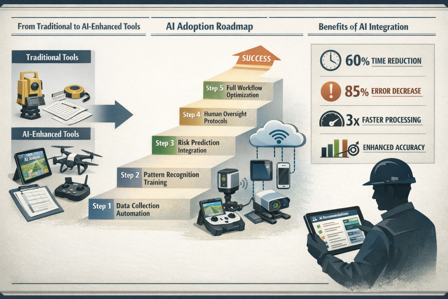
- ⏱️ Significant time savings: Automated analysis reduces data processing time by up to 60% compared to traditional manual methods
Understanding AI and Machine Learning in Property Surveying: Predicting Risks and Automating Analysis
What Makes AI Different from Traditional Surveying Methods
Traditional property surveying relies heavily on manual data collection, human observation, and time-intensive analysis. A surveyor visits a property, takes measurements, photographs defects, reviews comparable sales, and compiles findings into a report. This process, while thorough, is inherently limited by human capacity to process information.
Artificial intelligence fundamentally changes this equation. Machine learning algorithms can simultaneously analyze:
- Historical property transaction data spanning decades
- Real-time market conditions and pricing trends
- Environmental risk factors from multiple databases
- Satellite and drone imagery showing terrain changes
- Economic indicators affecting property values
- Neighborhood metrics including demographics and infrastructure
The difference isn't just speed—it's scope. Where a human surveyor might review dozens of comparable properties, an AI system can analyze thousands. Where manual inspection might miss subtle terrain shifts, machine learning algorithms detect millimeter-level changes across years of satellite data.[1]
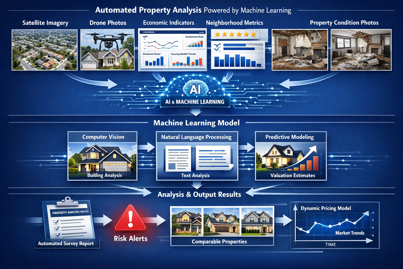
The Core Technologies Powering Modern Surveying AI
Several distinct AI technologies work together in modern property surveying applications:
| Technology | Function | Surveying Application |
|---|---|---|
| Computer Vision | Analyzes images and visual data | Identifies structural defects, classifies building types, assesses property condition |
| Natural Language Processing | Processes text and descriptions | Extracts insights from property listings, legal documents, historical records |
| Predictive Analytics | Forecasts future outcomes | Predicts market values, environmental risks, maintenance needs |
| Pattern Recognition | Identifies trends in large datasets | Detects terrain changes, market anomalies, risk patterns |
| Neural Networks | Learns from examples | Improves accuracy over time, adapts to regional variations |
These technologies don't operate in isolation. Modern AI systems integrate multiple approaches simultaneously. For example, a comprehensive property survey might employ computer vision to analyze photos, natural language processing to review planning documents, and predictive analytics to forecast future value—all within a single workflow.[2]
How Machine Learning Models Are Trained for Surveying Tasks
Machine learning models require extensive training before they can reliably analyze properties. This training process involves feeding algorithms thousands or millions of examples until they learn to recognize patterns independently.
For property risk prediction, training might include:
- Historical flood data mapped to topographic features
- Landslide incidents correlated with soil composition and rainfall
- Structural failures linked to building materials and age
- Market crashes associated with economic indicators
The model learns which combinations of factors indicate elevated risk. Over time, it develops the ability to assess new properties it's never seen before, predicting potential issues based on learned patterns.[1]
"Machine learning algorithms can analyze massive datasets to identify patterns, detect changes, and predict future developments—capabilities that are significantly reducing the time needed for data analysis compared to manual methods."
This learning process never truly ends. The most sophisticated systems continuously update their understanding as new data becomes available, improving accuracy with each analysis performed.
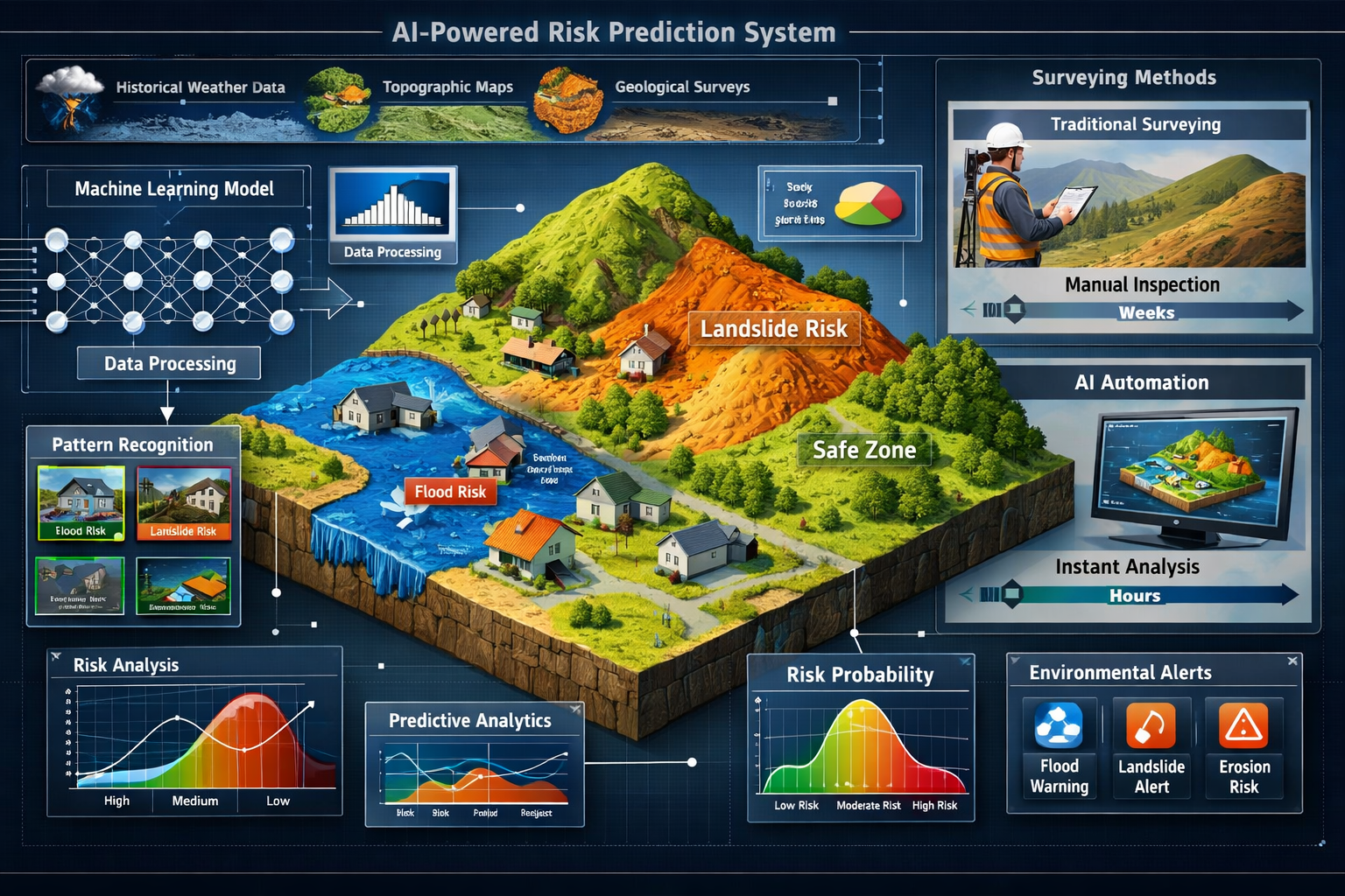
AI-Powered Risk Prediction in Property Surveying
Environmental Risk Assessment: Flooding and Landslides
Environmental hazards represent some of the most significant risks in property surveying. Traditional assessment methods rely on historical records and visual inspection, but these approaches often miss subtle warning signs or fail to account for changing climate patterns.
AI-powered environmental risk prediction operates differently. Machine learning systems analyze:
- Topographic data showing elevation, slope, and drainage patterns
- Historical weather records spanning decades
- Soil composition from geological surveys
- Vegetation coverage indicating erosion or stability
- Infrastructure changes affecting water flow
- Climate models projecting future conditions
By processing these diverse data sources simultaneously, AI systems can identify properties at elevated risk for flooding or landslides—even in areas with limited historical incidents. The algorithms detect subtle terrain changes over time, recognize patterns that precede environmental events, and generate probability assessments for various disaster scenarios.[1]
For example, a machine learning model might identify that properties with specific combinations of slope angle, soil type, and recent vegetation loss face a 73% increased landslide risk during heavy rainfall—a nuanced assessment impossible through manual analysis alone.
Structural Risk Detection Through Pattern Recognition
Beyond environmental hazards, AI excels at identifying structural vulnerabilities that might escape human observation. Computer vision algorithms trained on thousands of building defects can analyze property photos and identify:
- Crack patterns indicating foundation settlement
- Moisture staining suggesting hidden leaks
- Roof deterioration visible in aerial imagery
- Window alignment issues revealing structural movement
- Masonry degradation requiring immediate attention
These systems don't replace the detailed inspection performed during a Level 3 building survey, but they dramatically enhance efficiency. AI can pre-screen properties, flagging high-risk areas that require closer human examination while clearing low-risk elements for faster processing.[3]
The pattern recognition capabilities extend to historical analysis as well. By comparing current property images with photos from previous years, machine learning algorithms detect changes over time—subtle shifts that might indicate progressive structural problems requiring intervention.
Market Risk and Valuation Volatility Prediction
Property values don't exist in isolation. They respond to complex interactions between economic conditions, neighborhood trends, infrastructure development, and countless other factors. AI-driven market risk prediction models these relationships to forecast valuation volatility.
Modern machine learning systems integrate:
- Interest rate movements affecting buyer demand
- Employment statistics influencing purchasing power
- Infrastructure projects changing neighborhood desirability
- School performance ratings driving family relocations
- Crime statistics impacting perceived safety
- Commercial development altering area character
By analyzing how these factors historically influenced property values, AI models generate probabilistic forecasts. They might predict, for instance, that a planned transport link will increase values in one neighborhood by 15-20% over three years, while rising interest rates simultaneously dampen demand by 8-12%.[2]
These predictive scenario models allow surveyors to provide clients with more nuanced advice. Rather than a single static valuation, AI enables dynamic assessments showing how different future scenarios might affect property value—critical information for investors managing risk portfolios.
Automating Analysis: How AI Streamlines Surveying Workflows
Data Collection and Processing Automation
The foundation of any property survey is data—and collecting it has traditionally consumed enormous professional time. Surveyors gather information from land registries, planning departments, environmental agencies, market databases, and site visits, then manually compile and cross-reference these sources.
AI automation transforms this process. Modern systems can:
- Automatically retrieve relevant records from multiple databases
- Extract key information from lengthy documents using natural language processing
- Cross-reference data to identify inconsistencies or gaps
- Organize findings into structured formats for analysis
- Flag anomalies requiring human attention
For example, when preparing a homebuyer survey, AI systems can automatically gather planning history, flood risk data, comparable sales, and local authority records—tasks that might otherwise require hours of manual research. The surveyor receives a pre-compiled data package, ready for professional interpretation.[3]
This automation doesn't eliminate the need for site visits or physical inspection. Rather, it ensures surveyors arrive fully briefed, with comprehensive background information already processed and organized.
Automated Report Generation and Template Population
Once analysis is complete, surveyors face another time-intensive task: report writing. Standard survey reports follow established formats, with much content being template-driven descriptions of conditions, risks, and recommendations.
Machine learning systems now automate significant portions of this process:
- Photo classification: AI categorizes inspection photos by room and defect type
- Condition assessment: Algorithms generate standardized descriptions of observed issues
- Template population: Systems automatically fill standard report sections with relevant data
- Comparable evidence: AI selects and formats appropriate market comparables
- Risk flagging: Automated highlighting of issues requiring professional judgment
The result is a draft report that captures routine observations and data, leaving the surveyor to focus on professional judgment elements—interpreting findings, assessing significance, and providing recommendations. This division of labor can reduce report preparation time by 40-60% while maintaining quality standards.[3]
Importantly, these systems operate within the framework of professional standards. Organizations like RICS (Royal Institution of Chartered Surveyors) maintain that while automation can handle routine tasks, final reports must reflect professional surveyor oversight and judgment.
Integration with Drone Technology and Remote Sensing
The combination of AI and drone technology represents one of the most powerful advances in modern surveying. Drones equipped with high-resolution cameras and sensors can capture detailed imagery of properties from angles impossible for ground-based inspection—rooftops, large estates, inaccessible terrain.
The real breakthrough comes when AI processes this imagery:
- Roof condition assessment: Algorithms analyze drone photos to identify missing tiles, deterioration, or structural issues
- Large site mapping: AI processes hundreds of drone images to create comprehensive site plans
- Terrain analysis: Machine learning detects elevation changes, drainage patterns, and erosion
- Vegetation monitoring: Algorithms track changes in tree coverage or landscaping over time
- 3D modeling: AI converts drone imagery into detailed three-dimensional property models
For surveyors conducting topographic surveys, this integration dramatically expands capabilities. A drone can survey a large site in hours rather than days, while AI processes the resulting data into actionable insights—identifying features, measuring distances, and flagging potential issues.[3]
The technology proves particularly valuable for properties with access challenges. Rather than risking injury inspecting a steep roof or unstable terrain, surveyors deploy drones while AI handles the detailed analysis of captured imagery.
Machine Vision in Data-Scarce Environments
Not all properties benefit from comprehensive historical data. In developing areas, rural locations, or regions with limited record-keeping, traditional data-driven analysis struggles.
Advanced machine vision models address this challenge. Systems like Meta's Segment Anything can analyze satellite or aerial imagery to classify:
- Building types and construction methods
- Land use patterns
- Infrastructure presence and condition
- Vegetation and terrain characteristics
- Development density and layout
These AI models don't require extensive training data specific to each location. Instead, they apply learned pattern recognition to new areas, providing valuable preliminary analysis even where structured data doesn't exist.[3]
For surveyors working in such environments, this capability transforms early-stage site assessment. Rather than starting from zero, they receive AI-generated insights about building form, land use, and potential constraints—a foundation for more detailed investigation.
Practical Implementation: Adopting AI Tools in Surveying Practice
Assessing Your Practice's Readiness for AI Integration
Not every surveying practice needs to implement AI at the same pace or scale. Before investing in new technology, firms should honestly assess their readiness across several dimensions:
Data infrastructure: AI systems require quality data to function effectively. Does your practice maintain organized digital records? Are historical survey reports searchable and structured? Can you access relevant external databases?
Technical capacity: Implementing AI tools requires some technical capability. Does your team include members comfortable with new software? Can you provide training and support?
Volume and complexity: AI delivers greatest value where data volumes are high or analysis is complex. Do you conduct enough surveys to justify automation investment? Are your typical projects sufficiently complex to benefit from advanced analytics?
Client expectations: Are your clients requesting faster turnaround times or more sophisticated risk analysis? Does your market value technological innovation?
For smaller practices conducting primarily Level 2 surveys of standard residential properties, full AI implementation might be premature. However, even these firms can benefit from targeted automation of specific tasks like data retrieval or photo organization.
Selecting Appropriate AI Tools for Different Survey Types
The surveying market now offers numerous AI-powered tools, each designed for specific applications. Choosing the right solutions requires matching capabilities to your actual needs:
For residential property surveys:
- Automated valuation models (AVMs) for initial price guidance
- Photo analysis tools identifying common defects
- Report generation systems for standard survey formats
- Comparable sales databases with AI-powered matching
For commercial property assessment:
- Lease abstraction tools using natural language processing
- Rent roll analysis systems
- Market trend prediction models
- Environmental risk assessment platforms
For specialized surveys:
- Drone integration software with AI image analysis
- LiDAR processing tools for terrain mapping
- Structural analysis systems using computer vision
- Building information modeling (BIM) with AI enhancement
When evaluating tools, prioritize those that integrate with your existing workflows rather than requiring complete process overhauls. The most successful implementations start small—automating one or two tasks—then expand as teams gain confidence and experience.[5]
Training Staff and Maintaining Professional Standards
Technology adoption succeeds or fails based on human factors. Even the most sophisticated AI system delivers no value if staff don't understand how to use it effectively or trust its outputs.
Effective training programs should cover:
- Fundamental concepts: Help staff understand what AI can and cannot do
- Practical operation: Hands-on training with actual tools and workflows
- Quality control: Teaching staff to verify AI outputs and identify errors
- Professional judgment: Emphasizing when human expertise must override automated analysis
- Continuous learning: Regular updates as systems evolve and improve
Importantly, training should emphasize that AI augments rather than replaces professional expertise. The goal isn't to eliminate surveyor judgment but to free professionals from routine tasks, allowing them to focus on complex analysis requiring human insight.[3]
Professional bodies like RICS maintain clear standards: automation is acceptable for routine tasks, but final professional judgments, compliance decisions, and client recommendations must reflect qualified surveyor oversight. Any implementation must preserve this human-in-the-loop approach.
Cost-Benefit Analysis: Investment vs. Efficiency Gains
AI implementation requires investment—in software licenses, hardware upgrades, training time, and potential workflow disruption. Understanding the return on this investment is essential for sound business decisions.
Typical costs include:
- Software subscriptions (£200-2,000+ monthly depending on scale)
- Hardware upgrades for AI processing (£1,000-5,000)
- Training programs (£500-2,000 per staff member)
- Integration consulting (£2,000-10,000 for complex implementations)
- Ongoing support and maintenance (10-20% of initial costs annually)
Potential benefits:
- Time savings: 40-60% reduction in data processing and report preparation time
- Increased capacity: Ability to handle more surveys without additional staff
- Improved accuracy: Reduced human error in routine tasks
- Enhanced services: Ability to offer sophisticated risk analysis previously unavailable
- Competitive advantage: Faster turnaround times and more comprehensive insights
For a practice conducting 200 surveys annually, automation saving 3 hours per survey represents 600 hours of professional time—equivalent to adding a quarter-time surveyor without salary costs. The timeline for completing surveys can be significantly reduced, improving client satisfaction.
Most practices find that targeted AI implementation pays for itself within 12-18 months through efficiency gains, after which benefits continue accumulating.
Real-World Applications and Case Studies
AI in Flood Risk Assessment for Riverside Properties
Riverside properties present complex risk assessment challenges. Traditional methods rely on Environment Agency flood maps and historical incident records—useful but limited tools that don't account for changing climate patterns or recent development affecting water flow.
A surveying practice in Thames Valley implemented AI-powered flood risk analysis combining:
- 50 years of rainfall data analyzed for pattern changes
- Topographic modeling showing water flow during various flood scenarios
- Infrastructure changes affecting drainage and flood defenses
- Climate projections indicating future risk evolution
- Property-specific factors like elevation, flood barriers, and drainage
The AI system generated probabilistic flood risk assessments far more nuanced than standard flood zone classifications. For one property classified as "low risk" by traditional metrics, the AI identified a 34% probability of flooding within 25 years based on climate trends and upstream development—information that significantly affected the client's purchase decision and insurance planning.[1]
This capability proved particularly valuable for properties in marginal zones where traditional classifications provided limited guidance. The AI could distinguish between properties within the same flood zone based on specific elevation, drainage, and structural factors.
Automated Defect Detection in Period Properties
Period properties present unique surveying challenges. Their age, varied construction methods, and often-extensive modifications create complex assessment requirements. A London-based practice specializing in Victorian and Edwardian homes implemented computer vision AI to enhance their inspection process.
The system, trained on thousands of period property photos showing common defects, could analyze inspection images and identify:
- Subsidence indicators: Crack patterns suggesting foundation movement
- Damp penetration: Staining patterns indicating water ingress routes
- Timber decay: Visual signs of rot or insect damage
- Roof deterioration: Tile displacement or structural sagging
- Pointing failure: Mortar degradation requiring attention
During a structural survey of a 1890s terraced house, the AI flagged subtle crack patterns in the rear extension that the surveyor initially assessed as minor settlement. Closer examination revealed active movement requiring structural intervention—a potentially costly issue the AI's pattern recognition had correctly identified as significant.
The practice found that AI pre-screening reduced on-site inspection time by approximately 30% while improving defect detection accuracy, particularly for subtle issues that might otherwise be overlooked during time-pressured site visits.
Machine Learning in Commercial Property Valuation
A commercial property consultancy implemented machine learning for retail property valuation in regional shopping centers. Traditional valuation relied heavily on comparable evidence and surveyor judgment—effective but time-intensive and sometimes inconsistent across different valuers.
The AI system analyzed:
- Historical transaction data for thousands of retail units
- Footfall statistics from shopping center management
- Tenant mix and anchor store presence
- Economic indicators for the catchment area
- Online retail trends affecting physical store demand
- Transport accessibility metrics
- Competing retail developments within the region
The machine learning model generated valuations with 92% accuracy compared to eventual transaction prices—comparable to experienced human valuers but delivered in minutes rather than days. More significantly, the system identified value drivers that traditional analysis often missed, such as the correlation between specific tenant combinations and rental premiums.[2]
The consultancy didn't replace human valuers but rather repositioned them. Junior staff used AI for initial valuation modeling, while senior professionals focused on complex cases, client relationships, and strategic advice—a more efficient allocation of expertise.
Challenges and Limitations of AI in Property Surveying
Data Quality and Availability Issues
AI systems are only as good as the data they process. In property surveying, data quality varies enormously across regions, property types, and time periods. This creates several challenges:
Incomplete records: Many older properties lack comprehensive historical data. Planning records might be lost, previous surveys unavailable, or transaction histories incomplete. AI systems trained on complete datasets struggle when applied to properties with significant data gaps.
Inconsistent formats: Property data exists in countless formats—scanned documents, handwritten notes, various database structures, different measurement standards. Converting this heterogeneous information into formats AI can process requires significant effort.
Regional variations: AI models trained on London property data may perform poorly in rural Scotland, where construction methods, market dynamics, and risk factors differ substantially. Effective AI requires region-specific training data.
Outdated information: Property conditions change constantly. An AI system relying on five-year-old satellite imagery might miss recent developments, extensions, or deterioration.
Surveyors implementing AI must understand these limitations and maintain appropriate skepticism about automated outputs, particularly when data quality is questionable.[3]
The Irreplaceable Role of Professional Judgment
Despite impressive capabilities, AI cannot replicate certain aspects of professional surveying expertise:
Contextual understanding: An experienced surveyor recognizes when standard assumptions don't apply—when an unusual construction method, local geological condition, or unique property history requires specialized analysis. AI systems, trained on typical cases, may miss these exceptional circumstances.
Physical inspection nuances: No computer vision system yet matches human ability to assess property condition through touch, sound, and smell. Detecting damp through moisture feel, identifying structural issues through floor bounce, or recognizing dry rot by odor requires physical presence and experience.
Client communication: Understanding client concerns, explaining complex issues in accessible terms, and providing reassurance during stressful survey processes requires human empathy and communication skills AI cannot provide.
Ethical and legal responsibility: Professional surveyors carry legal liability for their assessments. They must exercise professional judgment, consider ethical implications, and take responsibility for recommendations—responsibilities that cannot be delegated to algorithms.[3]
The industry consensus is clear: AI augments professional expertise but doesn't replace it. The most effective approach combines automated data processing with human oversight and judgment.
Regulatory Compliance and Professional Standards
Professional surveying operates within strict regulatory frameworks. In the UK, RICS maintains detailed standards governing survey practice, valuation methodology, and professional conduct. AI implementation must comply with these requirements.
Key compliance considerations:
- Professional responsibility: RICS standards require that qualified professionals take responsibility for survey outputs, regardless of tools used
- Methodology transparency: Clients and regulators must understand how valuations and assessments are produced
- Quality assurance: AI outputs require verification processes ensuring accuracy and reliability
- Data protection: AI systems processing personal and property data must comply with GDPR and other privacy regulations
- Audit trails: Professional standards require documented decision-making processes
Some AI systems operate as "black boxes," producing outputs without clear explanation of their reasoning. This opacity conflicts with professional requirements for transparent, defensible methodology. Surveyors must either use explainable AI systems or maintain robust verification processes ensuring they can justify and defend automated outputs.[3]
Cybersecurity and Data Privacy Concerns
AI-powered surveying systems process sensitive information—property valuations, structural defects, owner details, financial data. This creates cybersecurity responsibilities:
Data protection obligations: Survey firms must ensure AI systems comply with data protection regulations, properly securing client information and limiting access to authorized personnel only.
Cloud processing risks: Many AI tools operate via cloud services, meaning sensitive property data is transmitted to and processed on external servers. Firms must assess whether this arrangement meets their security and confidentiality obligations.
Third-party vulnerabilities: Implementing AI often means relying on external software providers. Their security practices, data handling, and business continuity become your firm's concern.
Intellectual property: Training AI on your firm's historical survey data might create intellectual property questions about who owns the resulting models and insights.
Responsible AI implementation requires robust data governance, security protocols, and clear understanding of how third-party systems handle sensitive information.
The Future of AI and Machine Learning in Property Surveying
Emerging Technologies on the Horizon
The AI capabilities available in 2026 represent just the beginning. Several emerging technologies promise to further transform property surveying:
Quantum computing applications: As quantum computers become more accessible, they'll enable AI systems to process exponentially larger datasets and run more complex simulations. Property risk modeling could incorporate millions of variables simultaneously, generating unprecedented accuracy.
Advanced sensor integration: Next-generation sensors embedded in buildings will provide real-time structural health monitoring. AI systems will analyze this continuous data stream, detecting problems before they become visible—predictive maintenance at scale.
Augmented reality surveying: AR glasses overlaying AI-generated information onto physical properties will allow surveyors to see hidden infrastructure, historical changes, and risk assessments while conducting site inspections.
Blockchain verification: Combining AI analysis with blockchain-verified property records will create tamper-proof audit trails, increasing confidence in automated assessments.
Generative AI for scenario planning: Advanced AI will generate detailed simulations showing how properties might perform under various future scenarios—climate change, market shifts, regulatory changes—helping clients make more informed long-term decisions.[5]
Evolving Regulatory Frameworks
As AI becomes more prevalent in property surveying, regulatory bodies are developing frameworks to govern its use. RICS and similar organizations worldwide are establishing:
AI transparency standards: Requirements for surveyors to disclose when and how AI contributes to assessments, ensuring clients understand the methodology behind their reports.
Competency requirements: Professional development programs ensuring surveyors understand AI capabilities, limitations, and appropriate applications.
Quality assurance protocols: Standards for verifying AI outputs and maintaining professional oversight.
Ethical guidelines: Frameworks addressing bias in AI systems, ensuring automated analysis doesn't perpetuate or amplify existing inequalities in property assessment.
These evolving standards aim to harness AI's benefits while maintaining the professional integrity and public protection that surveying regulation exists to ensure.[3]
The Changing Role of Property Surveyors
AI won't eliminate surveying as a profession, but it will fundamentally change what surveyors do daily. The profession is evolving from data collection and routine analysis toward higher-value activities:
Strategic advisory roles: As AI handles routine valuation and risk assessment, surveyors increasingly focus on interpreting results, advising on complex decisions, and providing strategic property guidance.
AI system oversight: Surveyors are becoming responsible for selecting, implementing, and quality-controlling AI tools—requiring new technical competencies alongside traditional expertise.
Specialized expertise: Automation of routine work creates space for deeper specialization. Surveyors might focus on specific property types, risk categories, or analytical approaches where human expertise adds greatest value.
Client relationship management: With AI handling technical analysis, surveyors can invest more time in understanding client needs, explaining complex issues, and providing personalized service.
The most successful surveyors in this evolving landscape will be those who embrace AI as a tool enhancing their capabilities while maintaining the professional judgment, ethical standards, and client focus that define the profession.
Conclusion
AI and Machine Learning in Property Surveying: Predicting Risks and Automating Analysis represents far more than a technological upgrade—it's a fundamental transformation of how the industry operates. In 2026, these tools have moved from experimental novelty to essential infrastructure, processing vast datasets to detect risks, predict outcomes, and automate routine tasks with unprecedented speed and accuracy.
The evidence is compelling: AI systems can analyze millions of data points to predict flooding risks, identify structural defects through pattern recognition, and generate property valuations that adapt in real-time to market changes. They automate data collection, streamline report generation, and extend surveyor capabilities through integration with drones and remote sensing technology. The efficiency gains are substantial—40-60% time reductions in data processing, enhanced accuracy, and the ability to offer sophisticated analysis previously impossible.
Yet technology alone doesn't define the future of surveying. The most successful implementations recognize AI as an augmentation tool, not a replacement for professional expertise. Human judgment remains essential for contextual understanding, physical inspection, client communication, and ethical responsibility. The optimal approach combines automated data processing with professional oversight—machines handling routine tasks while surveyors focus on complex analysis, strategic advice, and client relationships.
Actionable Next Steps for Surveying Professionals
For individual surveyors:
- Invest in education: Develop basic understanding of AI capabilities and limitations through professional development courses
- Start small: Experiment with single-purpose AI tools for specific tasks rather than attempting wholesale practice transformation
- Maintain professional standards: Ensure any AI implementation preserves your ability to verify outputs and take professional responsibility for assessments
- Stay informed: Follow industry developments through professional bodies, conferences, and peer discussions
For surveying practices:
- Assess readiness: Honestly evaluate your data infrastructure, technical capacity, and business case for AI investment
- Pilot programs: Test AI tools on limited projects before full implementation, learning from experience
- Invest in training: Ensure staff understand both how to use AI tools and when to override automated outputs
- Review compliance: Verify that AI implementations meet RICS standards and regulatory requirements
- Monitor ROI: Track efficiency gains, accuracy improvements, and client satisfaction to justify ongoing investment
For property buyers and owners:
- Understand survey methods: When commissioning a property survey, ask how AI contributes to the assessment
- Value human expertise: Recognize that while AI enhances analysis, professional surveyor judgment remains crucial
- Request detailed risk analysis: Take advantage of AI-powered predictive modeling to understand long-term property risks
- Compare survey types: Consider whether AI-enhanced surveys offer better value for your specific property and circumstances
The integration of AI into property surveying is not a distant future possibility—it's happening now, reshaping the profession in real-time. Those who understand its capabilities, respect its limitations, and implement it thoughtfully will find themselves better equipped to serve clients, manage risks, and thrive in an increasingly data-driven industry. The question is no longer whether to adopt these technologies, but how to do so effectively while maintaining the professional standards that define quality surveying practice.
References
[1] The Future Of Land Surveying Technology And Upcoming Trends In 2026 – https://metricop.com/blogs/land-surveying/the-future-of-land-surveying-technology-and-upcoming-trends-in-2026
[2] How Ai And Machine Learning Are Reshaping Property Valuations In 2026 – https://www.thepaintedhinge.com/how-ai-and-machine-learning-are-reshaping-property-valuations-in-2026/
[3] What Surveyors Think Ai – https://ww3.rics.org/uk/en/modus/technology-and-data/surveying-tools/what-surveyors-think-ai.html
[5] Doubling Down On Digital – https://amerisurv.com/2026/02/01/doubling-down-on-digital/