
Imagine capturing an entire city block in stunning 3D detail—every building facade, street sign, and utility pole—all in the time it takes to drive through it once. This isn't science fiction; it's the reality of Mobile 3D Mapping: Creating Digital Twins Without Bulky Equipment in 2026. While traditional surveying methods require teams of technicians spending days setting up tripods and measuring points one at a time, modern mobile mapping systems are revolutionizing how professionals create digital twins of real-world environments.
The shift from stationary, bulky surveying equipment to sleek, vehicle-mounted systems represents one of the most significant advances in spatial data collection. Whether mapping transportation infrastructure, documenting construction sites, or creating detailed models for urban planning, mobile 3D mapping delivers sub-centimeter precision without the time, cost, and disruption associated with conventional approaches[3]. This transformation is making digital twin technology accessible to organizations that previously couldn't justify the expense or operational challenges of traditional methods.
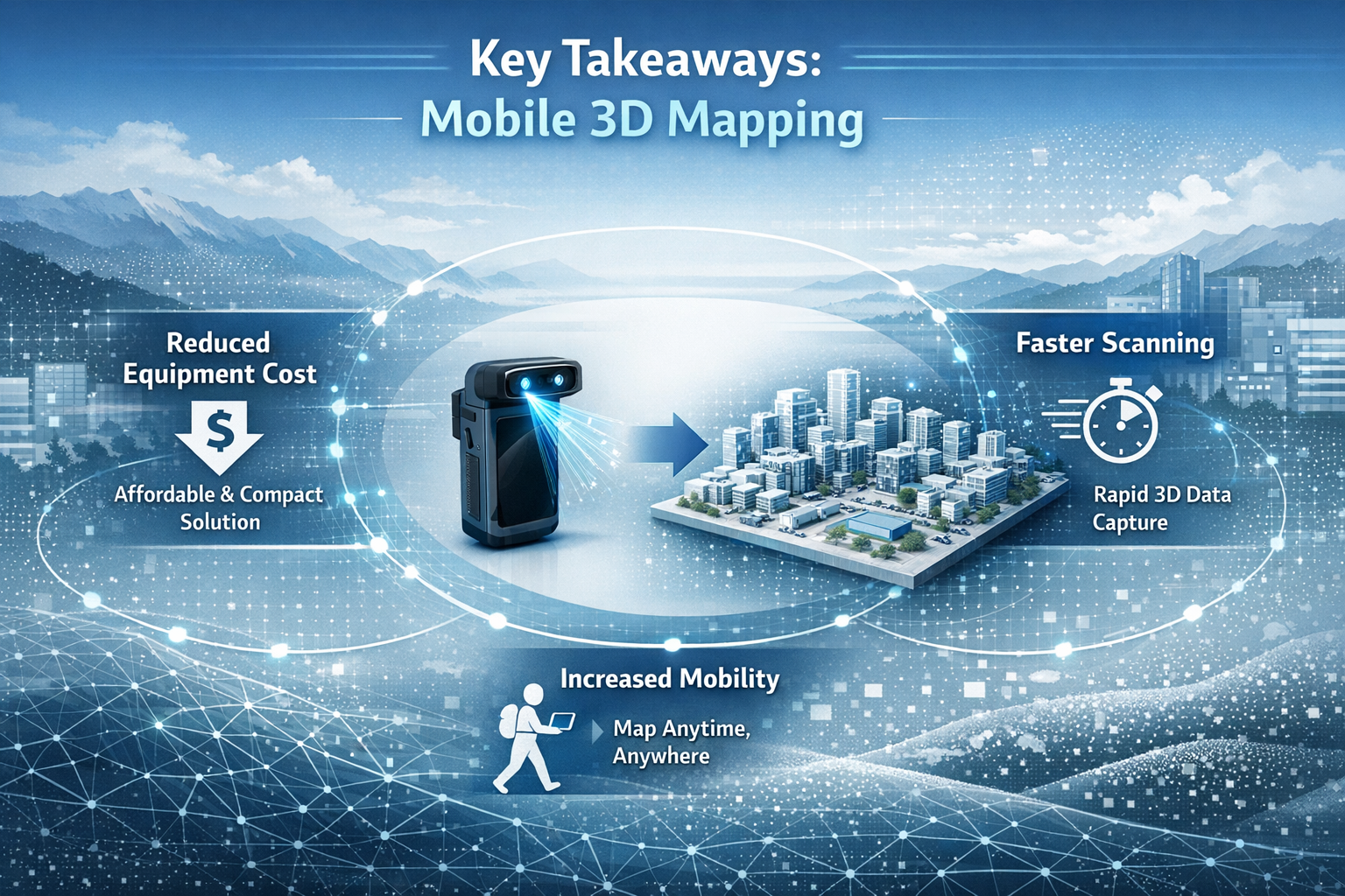
Key Takeaways
- 📱 Mobile mapping systems combine cameras, LiDAR, and positioning technology on vehicles, backpacks, and handheld devices to capture complex environments rapidly without bulky tripods or static setups
- ⚡ Speed and efficiency advantages allow teams to cover ground in hours instead of days, reducing field time by up to 80% compared to traditional surveying methods
- 🎯 Sub-centimeter accuracy enables detailed analysis of infrastructure, hazard detection, and compliance verification from remotely-analyzed digital twin models
- 🔄 Multi-platform workflows integrate vehicle-mounted, wearable, and handheld systems to capture both outdoor and indoor environments in a single unified digital twin
- 🌐 GIS integration allows seamless incorporation into existing workflows, enabling real-time collaboration, automated compliance, and continuous updates as physical environments change
Understanding Mobile 3D Mapping and Digital Twin Technology
What Are Digital Twins?
Digital twins are precise virtual replicas of physical objects, buildings, infrastructure, or entire environments. Unlike simple 3D models or photographs, digital twins incorporate accurate spatial measurements, textures, and often real-time data feeds that mirror their physical counterparts. These intelligent replicas enable professionals to analyze, simulate, and plan changes without disrupting the actual environment[5].
The value of digital twins extends across multiple industries:
- Transportation agencies use them to identify safety hazards and plan improvements
- Construction teams track progress and detect deviations from design specifications
- Facility managers optimize space utilization and coordinate maintenance
- Urban planners visualize development proposals in existing contexts
- Emergency responders prepare for incidents using accurate facility layouts
Creating these detailed replicas traditionally required expensive, time-consuming processes involving stationary laser scanners, photogrammetry rigs, and extensive manual measurements. Mobile 3D mapping changes this equation entirely.
The Evolution from Static to Mobile Mapping
Traditional surveying relied on total stations and terrestrial laser scanners mounted on tripods. While accurate, these methods required:
- Setting up equipment at multiple stations throughout a site
- Ensuring clear lines of sight to measurement targets
- Manually recording data at each position
- Coordinating traffic control or site closures
- Processing disconnected datasets into cohesive models
This approach worked well for small sites but became prohibitively expensive and disruptive for large-scale projects. A single mile of roadway might require dozens of setup positions, taking days to complete and creating safety concerns from stationary crews in active environments.
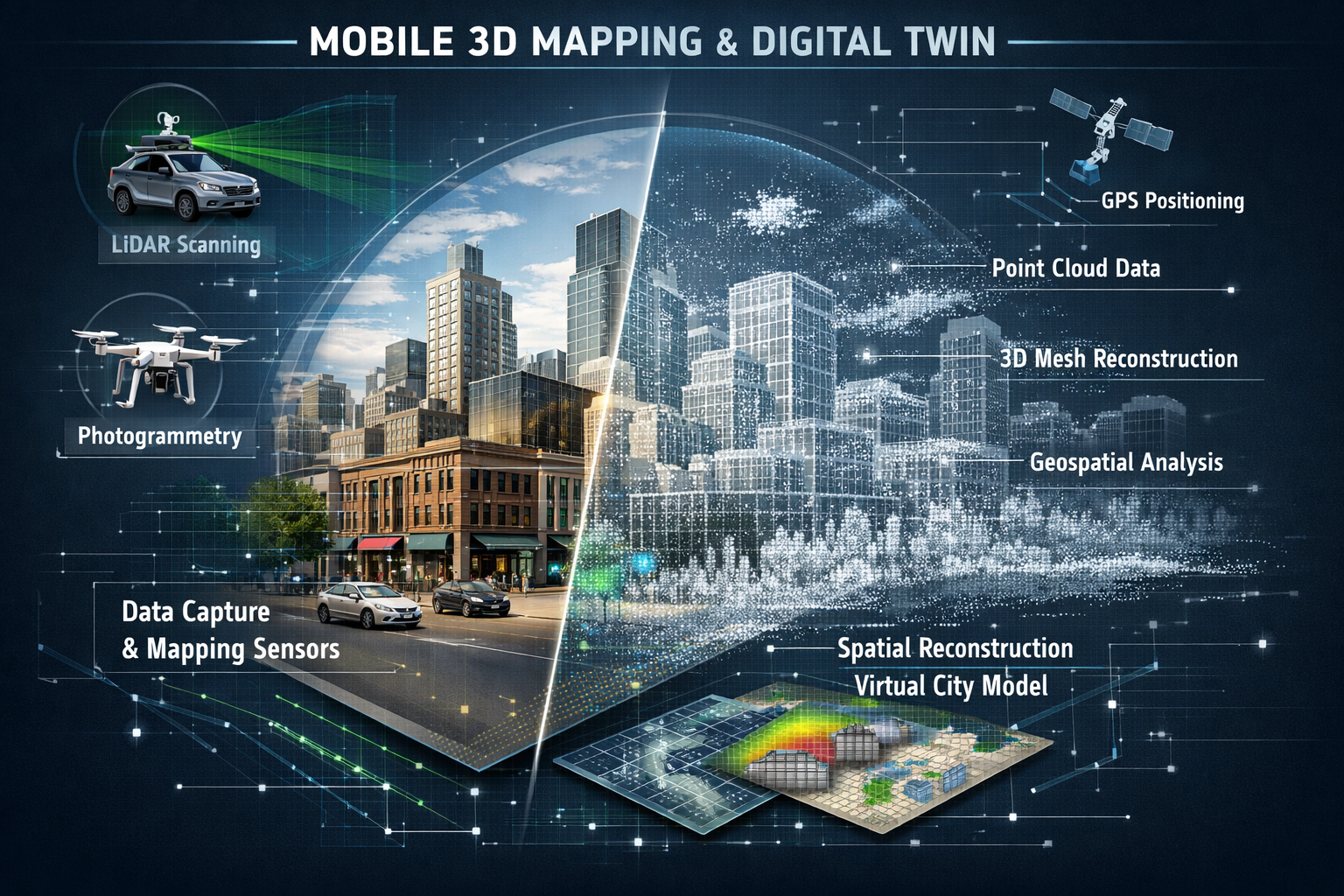
Mobile 3D mapping addresses these limitations by mounting sensors on moving platforms—primarily vehicles, but also backpacks, handheld devices, and even robotic systems. As the platform moves through an environment, integrated sensors continuously capture spatial data, creating seamless models without repeated setups[1].
How Mobile 3D Mapping Works: Technology and Platforms
Core Technologies in Mobile Mapping Systems
Mobile 3D Mapping: Creating Digital Twins Without Bulky Equipment relies on the integration of three fundamental technologies working in harmony:
1. LiDAR (Light Detection and Ranging)
LiDAR sensors emit laser pulses that bounce off surfaces and return to the sensor. By measuring the time each pulse takes to return, the system calculates precise distances to create point clouds—collections of millions of individual spatial measurements. Modern mobile LiDAR systems can capture hundreds of thousands of points per second while moving at normal driving speeds[1].
2. High-Resolution Cameras
Cameras capture visual information that adds texture and color to geometric data. Modern mobile mapping cameras feature:
- High resolution for detailed textures and meshes
- HDR capability to handle variable lighting conditions
- Global shutter mode to prevent distortion during motion
- Multi-camera synchronization for seamless panoramic coverage[1]
3. Positioning Systems (GNSS/IMU)
Global Navigation Satellite Systems (GNSS) combined with Inertial Measurement Units (IMU) track the exact position and orientation of the mapping platform. This georeferencing ensures that every data point captured knows its precise location in real-world coordinates, allowing different datasets to align perfectly[1].
Vehicle-Mounted Mobile Mapping Platforms
Vehicle-mounted systems represent the most common approach for Mobile 3D Mapping: Creating Digital Twins Without Bulky Equipment in outdoor environments. These platforms typically feature:
- Roof-mounted sensor arrays with 360-degree coverage
- Integrated processing computers for real-time data validation
- Power systems supporting hours of continuous operation
- Weatherproof housings protecting sensitive equipment
The primary advantage of vehicle-mounted systems is rapid area coverage. A single vehicle can map several miles of roadway, capturing detailed infrastructure data at normal driving speeds. This approach excels for:
- Transportation corridor mapping
- Utility infrastructure documentation
- Urban environment modeling
- Large campus or facility exterior surveys
For example, transportation agencies can create comprehensive digital twins of highway networks, identifying hazards like poor sightlines or hazardous curves through remote analysis with sub-centimeter accuracy[3]. This capability transforms safety planning from reactive to proactive.
Wearable and Handheld Systems for Complex Environments
While vehicle-mounted platforms excel at covering ground quickly, many environments aren't accessible to vehicles. This is where wearable backpack systems and handheld scanners become essential components of comprehensive mobile mapping workflows.
Wearable Systems (e.g., NavVis VLX3)
Backpack-mounted mapping systems allow operators to walk through buildings, pedestrian areas, and other vehicle-restricted spaces while continuously capturing data. These systems typically include:
- Multiple LiDAR sensors for complete coverage
- Panoramic camera arrays
- SLAM (Simultaneous Localization and Mapping) technology for GPS-denied environments
- Lightweight designs for extended operation
The Scan2Twin workflow demonstrated in February 2026 by geoConvergence showcases how wearable systems integrate with other platforms. The NavVis VLX3 captures continuous indoor mapping data that seamlessly connects with exterior vehicle-mounted captures, creating unified digital twins spanning both indoor and outdoor spaces[2].
Handheld Scanners (e.g., BLK2GO)
For detailed capture of specific areas or objects, handheld scanners offer maximum flexibility. Operators can move the device close to architectural details, mechanical systems, or other features requiring high-resolution documentation. These compact devices deliver professional-grade accuracy without the bulk of traditional equipment[2].
Specialized Platforms: Robotic Systems
The cutting edge of Mobile 3D Mapping: Creating Digital Twins Without Bulky Equipment includes robotic quadrupeds—dog-like robots that can navigate spaces too confined, dangerous, or difficult for human operators. The Scan2Twin workflow incorporates these systems for:
- Restricted access areas
- Low-clearance spaces
- Hazardous environments
- Continuous monitoring applications
These robotic platforms carry the same sensor suites as other mobile mapping systems but operate autonomously or via remote control, expanding the range of environments that can be safely and efficiently captured[2].
Comparing Mobile Mapping to Traditional Survey Methods
Speed and Efficiency Advantages
The most immediate benefit of Mobile 3D Mapping: Creating Digital Twins Without Bulky Equipment is dramatic time savings. Consider these comparisons:
| Aspect | Traditional Static Methods | Mobile Mapping Systems |
|---|---|---|
| Setup Time | 15-30 minutes per station | Continuous operation |
| Coverage Rate | 50-100m² per hour | 5,000-10,000m² per hour |
| Field Passes | Multiple setups required | Single pass often sufficient |
| Traffic Impact | Lane closures, extended disruption | Drive-by capture, minimal impact |
| Team Size | 2-4 technicians typically | 1-2 operators |
| Data Gaps | Common between stations | Continuous coverage |
This efficiency translates directly to cost savings. Fewer hours on-site means lower labor costs, reduced equipment rental fees, and minimal disruption to ongoing operations. For projects requiring regular updates—such as monitoring construction progress or infrastructure condition—mobile mapping enables frequent captures that would be economically impossible with traditional methods[1].
Accuracy and Precision Comparison
A common misconception is that mobile systems sacrifice accuracy for speed. In reality, modern Mobile 3D Mapping: Creating Digital Twins Without Bulky Equipment delivers sub-centimeter precision comparable to high-end static systems[3].
The key difference lies in how accuracy is achieved:
- Static systems excel at measuring individual points with extreme precision from a stable platform
- Mobile systems achieve comparable results through high-frequency measurements and sophisticated processing that averages thousands of readings
For most applications—including those requiring detailed analysis like structural engineering assessments or comprehensive building surveys—mobile mapping accuracy exceeds requirements while delivering additional benefits like complete coverage and photographic documentation.
Coverage and Completeness
Traditional surveying captures data where equipment is positioned, potentially missing areas between stations or behind obstructions. Mobile mapping creates continuous datasets with minimal gaps because sensors capture data throughout the entire journey[1].
This comprehensive coverage proves particularly valuable for:
- As-built documentation where every detail matters
- Condition assessments requiring complete surface inspection
- Clash detection in renovation projects
- Compliance verification against design specifications
The Northstowe housing development project in summer 2025 demonstrates this advantage. Skytech Cambridge captured over 40,000 high-resolution aerial photographs, creating a browser-based 3D model where every building and infrastructure element could be measured and analyzed[4]. This level of completeness would be impractical with ground-based static methods.
Safety and Accessibility Benefits
Mobile 3D Mapping: Creating Digital Twins Without Bulky Equipment significantly improves safety by reducing exposure to hazardous environments:
- Active roadways: Drive-by capture eliminates stationary crews in traffic
- Industrial facilities: Remote-controlled robots access dangerous areas
- Unstable structures: Rapid capture minimizes time in compromised buildings
- Confined spaces: Compact systems reach areas unsafe for extended occupation
This safety advantage extends to accessibility. Environments that are difficult or impossible to survey with tripod-mounted equipment—narrow corridors, cluttered spaces, areas with limited setup room—become readily mappable with handheld or wearable systems[2].
Real-World Applications and Use Cases
Transportation Infrastructure Digital Twins
Transportation agencies represent early adopters of Mobile 3D Mapping: Creating Digital Twins Without Bulky Equipment. Vehicle-mounted systems excel at capturing roadways, bridges, rail corridors, and related infrastructure.
Key applications include:
- Safety analysis: Identifying sight distance deficiencies, hazardous curves, and intersection conflicts
- Asset inventory: Cataloging signs, pavement markings, barriers, and utilities
- Maintenance planning: Documenting surface conditions and structural elements
- Design validation: Verifying as-built conditions against construction plans
The ability to analyze digital twins remotely with sub-centimeter accuracy enables detailed hazard detection that would require extensive field investigation using traditional methods[3]. Planners can test "what-if" scenarios before committing resources, reducing costly mistakes and improving project outcomes.
Construction and Development Projects
Construction sites present ideal use cases for mobile mapping technology. The dynamic nature of construction—with conditions changing daily—demands rapid, repeatable documentation methods.
Construction applications:
- Progress monitoring: Regular captures track work completion against schedules
- Quality control: Comparing as-built conditions to design models
- Change documentation: Recording site conditions before and after modifications
- Claims defense: Objective records of site conditions and work performed
The Northstowe project exemplifies this application. Regular aerial and ground-based mobile mapping created an evolving digital twin of the entire development, enabling stakeholders to visualize progress, coordinate trades, and verify compliance throughout construction[4]. Similar approaches benefit projects of all scales, from single buildings to entire districts.
Facility Management and Indoor Mapping
While vehicle-mounted systems dominate outdoor applications, wearable and handheld platforms have revolutionized indoor facility documentation. Organizations managing complex buildings—hospitals, universities, manufacturing plants, commercial real estate—use Mobile 3D Mapping: Creating Digital Twins Without Bulky Equipment to create comprehensive facility digital twins.
The Scan2Twin workflow demonstrates seamless integration with facility management systems. By connecting directly to Esri's ArcGIS Indoors, captured data enables:
- Turn-by-turn indoor routing for navigation
- Work order visualization in spatial context
- Space management tools for optimization
- Emergency response planning with accurate layouts[2]
This GIS-native approach means facility managers work within familiar systems rather than learning specialized 3D software. Updates captured through periodic mobile mapping keep digital twins synchronized with physical changes—renovations, equipment moves, space reconfigurations—ensuring information remains current and actionable[1].
Urban Planning and Smart Cities
City planners increasingly rely on comprehensive 3D models to visualize development proposals, analyze environmental impacts, and engage stakeholders. Mobile 3D Mapping: Creating Digital Twins Without Bulky Equipment enables creation of city-scale digital twins that were previously impractical.
Urban planning applications:
- Development visualization: Showing proposed buildings in accurate existing context
- Shadow studies: Analyzing sunlight impacts of new construction
- Viewshed analysis: Assessing visual impacts from multiple perspectives
- Infrastructure planning: Coordinating utilities, transportation, and development
The scalability of mobile mapping workflows—handling everything from individual facilities to entire districts with new data integrating seamlessly—makes it possible to maintain living digital twins of growing cities[1]. As urban environments evolve, regular mobile mapping updates keep digital representations current.
Heritage Documentation and Preservation
Historic buildings and sites benefit enormously from non-invasive, rapid documentation. Mobile mapping systems capture intricate architectural details without physical contact or disruptive equipment installations.
For organizations conducting detailed building surveys or comprehensive structural assessments, mobile 3D mapping provides baseline documentation that supports conservation planning, restoration work, and ongoing monitoring of historic structures.
Advanced Features and Capabilities
AI-Enhanced Object Detection and Analysis
Modern Mobile 3D Mapping: Creating Digital Twins Without Bulky Equipment incorporates artificial intelligence to extract semantic information from captured data. Neural networks trained to recognize specific objects can automatically identify and classify:
- Traffic signs and pavement markings
- Utility poles and overhead wires
- Vegetation and landscape features
- Building components and architectural elements
- Equipment and mechanical systems
This automated object detection transforms raw point clouds and imagery into intelligent digital twins that "know" what they contain. Rather than manually identifying every asset, AI processes datasets automatically, dramatically reducing post-processing time and enabling rapid delivery of actionable information[1].
Privacy and Compliance Automation
As mobile mapping captures public and private spaces, privacy concerns require attention. Modern systems include automated anonymization features that:
- Detect and blur faces in imagery
- Obscure license plates and identifying information
- Comply with GDPR, HIPAA, and other regulations
- Enable selective redaction of sensitive areas
The Scan2Twin platform specifically addresses these concerns with built-in compliance tools, allowing organizations to capture comprehensive data while respecting privacy requirements[2]. This automation eliminates manual review of thousands of images, ensuring regulatory compliance without slowing project delivery.
Real-Time Data Integration
The most advanced digital twin implementations integrate real-time data feeds with physical world models captured through mobile mapping. This convergence enables dynamic applications:
- Traffic management: Overlaying live traffic data on infrastructure models
- Environmental monitoring: Combining sensor readings with spatial context
- Facility operations: Showing equipment status within accurate 3D layouts
- Emergency response: Displaying incident locations with precise building details
This integration transforms static documentation into living operational tools that support real-time decision-making[3]. The accurate spatial foundation provided by mobile mapping ensures that dynamic data displays in correct context.
Continuous Updates and Change Detection
Unlike traditional surveys that produce point-in-time snapshots, Mobile 3D Mapping: Creating Digital Twins Without Bulky Equipment enables continuous monitoring through regular re-capture. Comparing successive datasets reveals:
- Subtle structural movement or settlement
- Gradual deterioration requiring maintenance
- Unauthorized changes or encroachments
- Construction progress against schedules
This change detection capability transforms digital twins from documentation tools into predictive maintenance systems that identify problems before they become costly failures[1]. The speed and efficiency of mobile mapping makes frequent updates economically viable, keeping digital twins synchronized with evolving physical environments.
Implementing Mobile 3D Mapping: Practical Considerations
Choosing the Right Platform for Your Needs
Selecting appropriate Mobile 3D Mapping: Creating Digital Twins Without Bulky Equipment requires matching platform capabilities to project requirements:
Vehicle-Mounted Systems work best for:
- Large outdoor areas (roadways, campuses, districts)
- Linear infrastructure (utilities, transportation corridors)
- Projects requiring rapid area coverage
- Environments with vehicle access
Wearable Backpack Systems excel at:
- Indoor environments and buildings
- Pedestrian-only areas
- Multi-level facilities
- Continuous indoor/outdoor workflows
Handheld Scanners suit:
- Detailed feature documentation
- Complex architectural elements
- Confined or cluttered spaces
- Supplementary capture to fill gaps
Robotic Platforms address:
- Hazardous or inaccessible areas
- Confined spaces with clearance restrictions
- Continuous monitoring applications
- Dangerous environment documentation
Many comprehensive projects benefit from multi-platform approaches like the Scan2Twin workflow, which combines all these methods to eliminate gaps and ensure complete coverage[2].
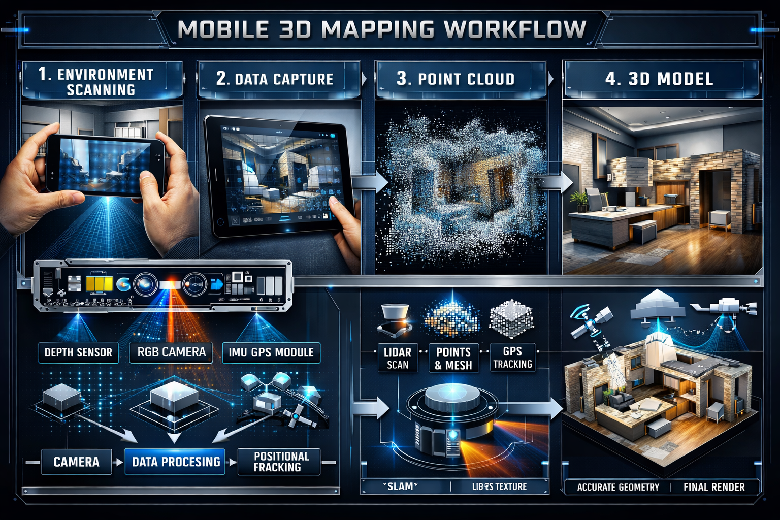
Data Processing and Workflow Integration
Capturing data represents only the first step. Efficient processing workflows transform raw sensor data into usable digital twins:
- Data validation: Ensuring complete coverage and quality during capture
- Registration: Aligning multiple datasets into unified coordinate systems
- Point cloud processing: Cleaning, classifying, and optimizing spatial data
- Mesh generation: Creating surface models from point clouds
- Texture mapping: Applying photographic imagery to geometric models
- Object extraction: Identifying and cataloging specific features
- Format conversion: Exporting to required formats for end users
Modern platforms increasingly automate these steps, with cloud-based processing delivering finished digital twins within hours of capture. The GIS-native pipeline exemplified by Scan2Twin integration with ArcGIS Indoors demonstrates how mobile mapping data flows directly into existing organizational workflows without requiring specialized 3D software expertise[2].
Cost Considerations and ROI
While Mobile 3D Mapping: Creating Digital Twins Without Bulky Equipment requires initial investment in technology or services, the return on investment typically justifies costs through:
- Reduced field time: 50-80% fewer hours on-site compared to traditional methods
- Lower labor costs: Smaller crews and faster completion
- Minimal disruption: Avoiding costly traffic control or facility closures
- Comprehensive documentation: Reducing expensive return visits for missing data
- Improved decision-making: Preventing costly errors through accurate visualization
Organizations can access mobile mapping through:
- Service providers: Contracting specialists for specific projects
- Equipment purchase: Acquiring systems for ongoing internal use
- Hybrid approaches: Owning basic equipment while contracting specialized platforms
For property professionals conducting building surveys or structural assessments, partnering with mobile mapping specialists can enhance service offerings without capital equipment investment.
Quality Assurance and Accuracy Verification
Ensuring Mobile 3D Mapping: Creating Digital Twins Without Bulky Equipment meets project accuracy requirements involves:
Pre-Capture Planning:
- Establishing control points with known coordinates
- Planning routes for complete coverage
- Identifying challenging areas requiring special attention
- Defining accuracy specifications and deliverable formats
During Capture:
- Real-time data quality monitoring
- Overlap verification between passes
- Immediate identification of gaps or issues
- Documentation of site conditions affecting data
Post-Processing Validation:
- Comparing to control points
- Checking alignment between datasets
- Verifying completeness of coverage
- Accuracy reporting and documentation
Professional mobile mapping services provide accuracy certifications documenting achieved precision, supporting applications requiring verified measurements for compliance documentation or legal purposes.
The Future of Mobile 3D Mapping and Digital Twins
Emerging Technologies and Trends
Mobile 3D Mapping: Creating Digital Twins Without Bulky Equipment continues evolving with several emerging trends shaping the future:
Enhanced Sensor Integration
Next-generation systems combine traditional LiDAR and cameras with:
- Thermal imaging for energy audits and building diagnostics
- Hyperspectral sensors for material identification
- Ground-penetrating radar for subsurface mapping
- Gas detection for environmental monitoring
Miniaturization and Accessibility
As sensors become smaller and more affordable, mobile mapping capabilities are appearing in consumer devices. Smartphone-based systems already capture basic 3D models, with professional-grade accuracy increasingly accessible at lower price points.
Autonomous Platforms
Self-driving vehicles and autonomous drones are expanding mobile mapping capabilities:
- Scheduled automatic updates without human operators
- Continuous monitoring of critical infrastructure
- Coverage of dangerous or remote environments
- 24/7 data collection capabilities
AI and Machine Learning Advances
Artificial intelligence continues improving automated feature extraction, with neural networks becoming capable of:
- Recognizing complex objects and conditions
- Detecting subtle changes indicating problems
- Predicting maintenance needs from visual cues
- Generating semantic models automatically[1]
Integration with Building Information Modeling (BIM)
The convergence of mobile mapping and BIM workflows enables seamless coordination between design intent and as-built reality. Digital twins captured through mobile mapping provide:
- Accurate existing conditions for renovation planning
- As-built verification during construction
- Facility management data for operational BIM
- Change documentation throughout building lifecycles
This integration benefits professionals conducting construction surveys and project management, ensuring coordination between physical construction and digital documentation.
Expanding Applications Across Industries
As Mobile 3D Mapping: Creating Digital Twins Without Bulky Equipment becomes more accessible, applications expand into new sectors:
Agriculture: Crop monitoring, precision farming, and yield optimization
Insurance: Claims assessment, risk evaluation, and underwriting
Real Estate: Virtual tours, accurate measurements, and property marketing
Entertainment: Location scanning for film, gaming, and virtual production
Archaeology: Site documentation, excavation planning, and preservation
Each industry adapts the core technology to specific needs, driving innovation and expanding the ecosystem of tools and services.
Standardization and Interoperability
As digital twin adoption grows, industry efforts focus on standardization to ensure:
- Data formats compatible across platforms
- Quality specifications for different applications
- Metadata standards for asset management
- Interoperability between software systems
These standards will accelerate adoption by reducing vendor lock-in and enabling organizations to integrate mobile mapping data with existing systems more easily.
Conclusion
Mobile 3D Mapping: Creating Digital Twins Without Bulky Equipment represents a fundamental shift in how professionals capture, document, and analyze the physical world. By replacing time-consuming, disruptive traditional surveying methods with rapid, comprehensive mobile platforms, organizations across industries can create accurate digital twins that were previously impractical or impossible.
The technology has matured beyond early adoption to become a reliable, proven approach delivering sub-centimeter accuracy while dramatically reducing field time and costs[3]. Multi-platform workflows combining vehicle-mounted, wearable, handheld, and robotic systems ensure complete coverage of any environment, from transportation corridors to complex facilities[2]. Integration with GIS and BIM systems enables seamless incorporation into existing workflows, while AI-enhanced processing automates feature extraction and compliance tasks[1].
For property professionals, surveyors, and organizations managing built environments, mobile 3D mapping offers compelling advantages:
✅ Faster project completion with 50-80% reduction in field time
✅ Comprehensive documentation eliminating gaps and return visits
✅ Improved safety by reducing exposure to hazardous environments
✅ Enhanced accuracy supporting detailed analysis and compliance verification
✅ Continuous monitoring enabling predictive maintenance and change detection
✅ Better stakeholder communication through accurate 3D visualization
Next Steps: Getting Started with Mobile 3D Mapping
Whether you're considering mobile mapping for a specific project or exploring how digital twins could transform your organization's operations, these actionable steps will help you begin:
-
Define Your Objectives: Identify specific problems mobile mapping could solve—documentation needs, safety concerns, efficiency improvements, or analysis requirements.
-
Assess Your Environment: Determine which platform types (vehicle, wearable, handheld, robotic) suit your typical projects based on access, coverage requirements, and environment characteristics.
-
Evaluate Service Providers: Research mobile mapping specialists serving your region, reviewing portfolios, accuracy specifications, and integration capabilities with your existing systems.
-
Start with a Pilot Project: Test mobile mapping on a representative project to evaluate results, workflow integration, and return on investment before committing to larger implementations.
-
Plan for Integration: Consider how digital twin data will flow into your existing processes—whether supporting building surveys, structural assessments, or facility management workflows.
-
Invest in Training: Ensure team members understand how to work with 3D data, whether through software training, workflow development, or partnering with specialists who provide turnkey solutions.
-
Establish Update Protocols: Plan for regular re-capture to maintain digital twin currency, enabling change detection and continuous monitoring benefits.
The transition from bulky traditional equipment to streamlined mobile mapping systems isn't just about adopting new technology—it's about fundamentally improving how professionals understand, analyze, and manage the built environment. As systems become more capable, accessible, and integrated with existing workflows, Mobile 3D Mapping: Creating Digital Twins Without Bulky Equipment will increasingly become the standard approach rather than the innovative alternative.
Organizations that embrace this technology now position themselves to deliver better outcomes, operate more efficiently, and provide enhanced value to clients and stakeholders in an increasingly digital world. The future of spatial documentation is mobile, comprehensive, and intelligent—and that future is already here.
References
[1] 3d Mobile Mapping For Digital Twins Camera Features That Ensure Accuracy – https://www.e-consystems.com/blog/camera/applications/3d-mobile-mapping-for-digital-twins-camera-features-that-ensure-accuracy/
[2] Geoconvergence Introduces Scan2twin Mobile Mapping For Digital Twin Creation Gis Integration – https://www.geoweeknews.com/news/geoconvergence-introduces-scan2twin-mobile-mapping-for-digital-twin-creation-gis-integration
[3] Mapping The Future Of Digital Twins Transforming Transportation Cad To Gis – https://sanborn.com/blog/mapping-the-future-of-digital-twins-transforming-transportation-cad-to-gis/
[4] Mapping A New Town With 3d Digital Twin Technology – https://www.gim-international.com/content/news/mapping-a-new-town-with-3d-digital-twin-technology
[5] How Intelligent Digital Replicas Are Reshaping The World – https://geospatial.trimble.com/blog/geospatial/en-US/article/how-intelligent-digital-replicas-are-reshaping-the-world