
Picture a surveying team spending weeks trudging across rugged terrain with heavy equipment, manually collecting data points one at a time. Now imagine completing that same job in just hours with centimeter-level accuracy and a fraction of the cost. This isn't science fiction—it's the reality of Revolutionizing Land Surveying: The Rise of Drone Technology and UAV Applications in 2026. As affordable drones equipped with LiDAR sensors and high-resolution cameras become standard tools, the surveying industry is experiencing its most significant transformation in decades. 🚁
The convergence of advanced sensor technology, artificial intelligence, and autonomous flight systems has fundamentally changed how professionals approach topographic surveys, construction monitoring, and land development projects. What once required substantial manpower, time, and financial investment can now be accomplished with remarkable efficiency and precision.
Key Takeaways
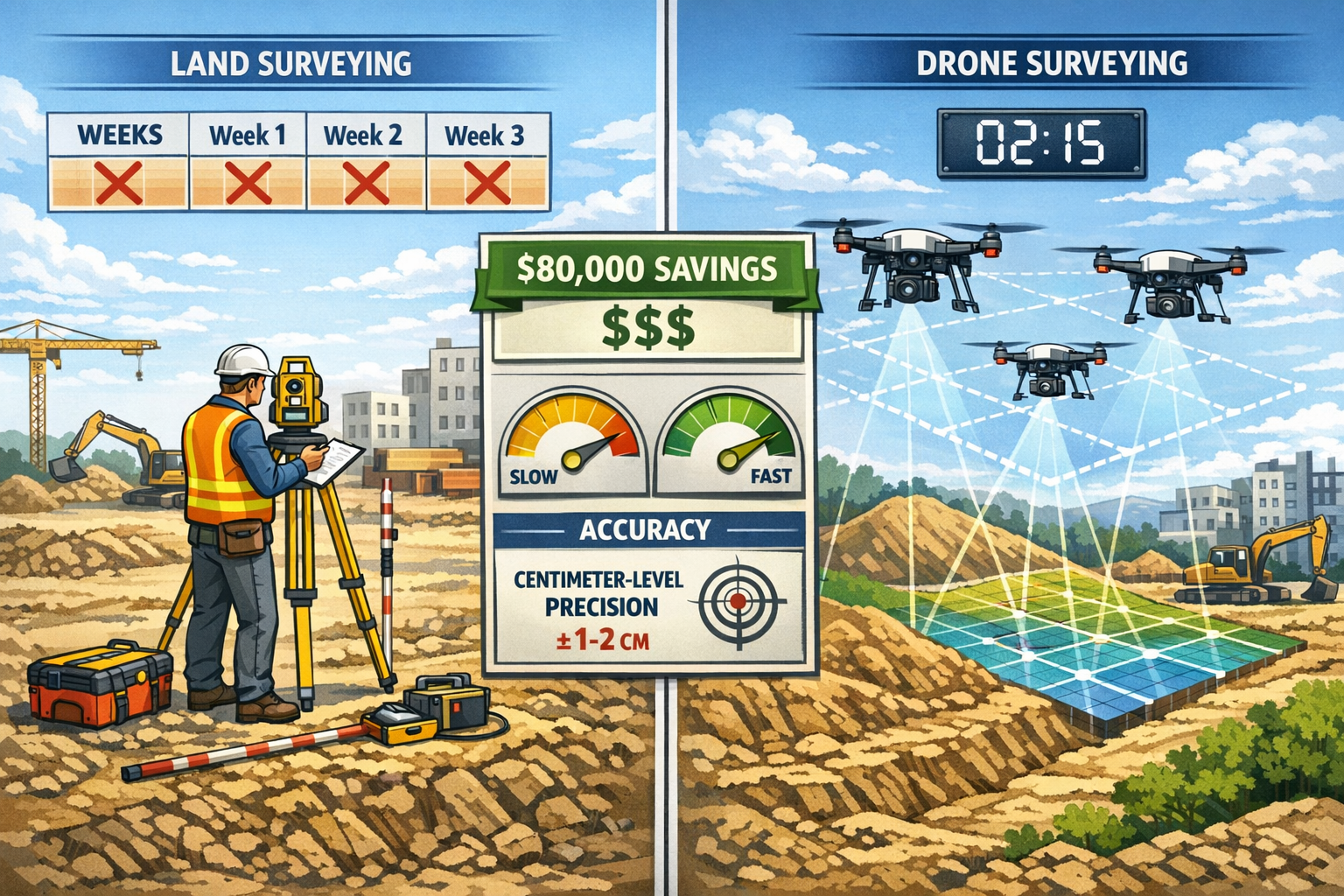
- Dramatic time savings: Drone surveys reduce fieldwork from weeks to hours, enabling faster project decision-making and progression across construction and land development sectors
- Significant cost reduction: Companies are saving tens of thousands of dollars annually by replacing traditional surveying methods with drone technology, with one firm documenting over $80,000 in savings
- Centimeter-level precision: Modern drones equipped with high-resolution cameras and LiDAR sensors deliver accuracy comparable to traditional methods while accessing previously unreachable terrain
- AI-powered automation: Artificial intelligence now handles data interpretation, automatically identifying objects, defects, and patterns that previously required days of manual analysis
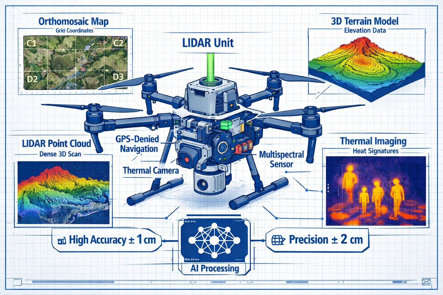
- Expanded capabilities: GPS-denied sensors enable surveying in tunnels, mines, and interior structures, while autonomous swarms coordinate complex surveys with minimal human intervention
Understanding the Drone Surveying Revolution in 2026
The surveying profession has evolved dramatically from its traditional roots. While conventional methods using theodolites, total stations, and GPS equipment remain valuable, they come with significant limitations—particularly regarding time, cost, and accessibility to challenging terrain.
The Traditional Surveying Challenge
Traditional land surveying requires substantial resources. Ground-based teams must physically traverse every section of a site, setting up equipment repeatedly and manually recording measurements. For large-scale topographic surveys spanning hundreds of acres, this process can take weeks or even months to complete[2]. The labor costs, equipment expenses, and project delays add up quickly.
Additionally, certain areas present safety hazards or physical impossibilities for ground crews. Steep slopes, dense vegetation, unstable ground, and hazardous industrial sites create barriers that slow progress or prevent data collection entirely.
How Drones Transform the Surveying Landscape
Unmanned Aerial Vehicles (UAVs) address these challenges head-on. By capturing data from above, drones eliminate the need for surveyors to physically access every point on a site. A drone equipped with appropriate sensors can survey the same area in hours that would take ground crews days or weeks[2].
The technology has matured significantly. What began as experimental applications has evolved into standardized industry practices with proven workflows, established accuracy standards, and regulatory frameworks[5]. Companies across construction, engineering, mining, and environmental sectors now integrate drone surveys as standard operating procedure.
Key Technologies Driving the Revolution
Several technological advances have converged to make drone surveying practical and reliable:
High-Resolution Cameras: Modern survey drones carry cameras capable of capturing images with exceptional detail. When processed using photogrammetry software, these images create accurate 3D models and orthomosaic maps with centimeter-level accuracy[3].
LiDAR Sensors: Light Detection and Ranging (LiDAR) technology uses laser pulses to measure distances with extreme precision. LiDAR-equipped drones can penetrate vegetation canopy and create detailed elevation models even in heavily forested areas. This capability has proven invaluable for applications ranging from forest carbon monitoring to archaeological discoveries[2].
GPS and RTK Systems: Real-Time Kinematic (RTK) GPS provides positioning accuracy within centimeters, ensuring that every data point collected has precise geographic coordinates.
Advanced Processing Software: Specialized software transforms raw drone data into usable deliverables—orthomosaic maps, digital elevation models, 3D point clouds, contour maps, and volumetric calculations.
The Technical Capabilities Revolutionizing Land Surveying: The Rise of Drone Technology and UAV Applications in 2026
Modern drone surveying systems offer capabilities that were unimaginable just a few years ago. Understanding these technical advances helps explain why the technology has achieved such rapid adoption across the surveying profession.
Autonomous Drone Swarms and Coordinated Operations
One of the most significant developments is the emergence of autonomous drone swarms. These systems allow multiple drones to work together with minimal human intervention, following precisely coordinated flight paths to survey large areas quickly and efficiently[1].
The swarms operate through sophisticated algorithms that:
- Divide survey areas into optimal flight zones
- Coordinate movements to avoid collisions
- Ensure complete coverage with appropriate image overlap
- Automatically adjust for changing conditions
- Return to base for battery swaps and resume operations seamlessly
This coordinated approach dramatically increases survey speed while maintaining data quality and accuracy.
Precision and Accuracy Standards
Accuracy remains paramount in surveying, and modern drones meet professional standards. When properly configured and operated, drone surveys achieve centimeter-level accuracy that rivals traditional methods[3].
Several factors influence accuracy:
| Factor | Impact on Accuracy |
|---|---|
| Sensor Quality | Higher resolution cameras and precision LiDAR units produce more detailed data |
| Flight Altitude | Lower altitude flights capture finer detail but cover less area per flight |
| Ground Control Points | Surveyed reference points significantly improve absolute accuracy |
| RTK/PPK GPS | Real-time or post-processed kinematic positioning enhances coordinate precision |
| Weather Conditions | Wind, lighting, and atmospheric conditions affect data quality |
| Processing Methods | Advanced photogrammetry algorithms extract maximum accuracy from imagery |
For most construction and land development applications, the accuracy achieved by drone surveys exceeds project requirements while delivering results much faster than traditional methods.
Comprehensive Data Output Capabilities
Modern drone surveying platforms generate diverse data products that serve multiple project needs[3]:
Orthomosaic Maps: Geometrically corrected aerial images that combine hundreds of individual photos into a single, accurate, measurable map of the entire site.
Digital Elevation Models (DEMs): Detailed representations of terrain elevation that enable cut-and-fill calculations, drainage analysis, and grading design.
3D Point Clouds: Dense collections of millions of precisely positioned points that create detailed three-dimensional representations of structures and terrain.
Thermal Imagery: Infrared sensors detect temperature variations useful for identifying moisture intrusion, insulation defects, and equipment malfunctions.
Multispectral Data: Specialized sensors capture data beyond visible light, supporting applications in agriculture, environmental monitoring, and vegetation analysis.
This variety of outputs from a single survey flight provides comprehensive information that supports decision-making across multiple project disciplines.
Breakthrough GPS-Denied Navigation Sensors
A major limitation of early drone surveying was dependence on GPS signals. Traditional drones couldn't operate in tunnels, mines, dense urban canyons, or interior spaces where satellite signals are blocked or unreliable.
GPS-denied sensors represent a significant breakthrough, enabling drones to navigate and survey in environments previously requiring dangerous manual inspections[4]. These advanced systems use:
- Visual-Inertial Odometry: Cameras and inertial measurement units work together to track position by analyzing visual features
- LiDAR-Based SLAM: Simultaneous Localization and Mapping creates real-time 3D maps while tracking the drone's position within them
- Ultrasonic and Optical Sensors: Proximity detection prevents collisions in confined spaces
This capability opens entirely new applications, from inspecting the interiors of concrete structures and bridges to surveying underground mining operations and utility tunnels—tasks that previously exposed workers to significant safety risks.
Real-World Applications and Case Studies in Construction and Land Development
The true measure of any technology lies in its practical applications. Across the construction and land development sectors, drone surveying has proven its value through tangible results and measurable benefits.
Construction Site Monitoring and Progress Tracking
Construction projects involve complex coordination between design, scheduling, and execution. Drone surveys provide real-time insights into construction progress and help ensure work aligns with planned specifications[2].
Regular Monitoring: Because drone surveys are relatively inexpensive compared to traditional methods, project managers can conduct frequent surveys throughout construction phases. Weekly or even daily aerial surveys track progress, identify potential issues early, and document site conditions.
Visual Documentation: Overlaid drone images from different dates create powerful visual comparisons showing exactly how construction has progressed. These comparisons help:
- Verify that work matches approved plans
- Identify deviations or errors before they become costly problems
- Document project milestones for stakeholders
- Resolve disputes with objective visual evidence
- Support billing and payment applications
Volumetric Calculations: Earthwork represents a significant cost component in many construction projects. Drone surveys accurately measure stockpile volumes, cut-and-fill quantities, and material movements. This precision helps prevent over-ordering materials and ensures accurate payment for earthwork quantities.
Large-Scale Topographic Surveys for Land Development
Land development projects require detailed topographic information before design work can begin. Traditional surveys of large parcels are time-consuming and expensive. Drone technology transforms this process.
Speed Advantages: A drone can survey hundreds of acres in a single day—work that might take a ground crew weeks to complete[2]. This acceleration enables:
- Faster project initiation and design development
- Reduced holding costs for undeveloped land
- Quicker response to market opportunities
- Earlier identification of site constraints
Terrain Accessibility: Development sites often include areas difficult or dangerous to access on foot—wetlands, steep slopes, dense vegetation, or unstable ground. Drones survey these areas as easily as open terrain, providing complete site coverage without safety concerns.
Comprehensive Site Analysis: The detailed elevation data from drone surveys supports multiple analyses:
- Drainage and watershed delineation
- Slope stability assessment
- Optimal building pad locations
- Road and utility routing
- Environmental impact evaluation
Similar comprehensive analysis capabilities benefit those conducting structural surveys and other detailed property assessments.
Documented Cost Savings: The Dudek Case Study
Real-world financial impact provides compelling evidence of drone technology's value. Dudek, an environmental engineering consulting firm, documented savings of more than $80,000 in a single year after integrating drone technology with ArcGIS geographic information systems[5].
The firm's experience illustrates several cost-saving mechanisms:
Reduced Field Time: Fewer person-hours in the field translates directly to lower labor costs. Projects that previously required multiple surveyors working for days now need one or two drone operators for hours.
Equipment Efficiency: A single drone system replaces multiple pieces of traditional surveying equipment, reducing capital costs, maintenance expenses, and transportation needs.
Expanded Service Capabilities: The ability to offer drone surveying services opened new revenue opportunities while delivering existing services more profitably.
Faster Project Delivery: Quicker turnaround times enabled the firm to handle more projects with the same staff, improving overall productivity and profitability.
This case demonstrates that while the initial investment in drone technology is substantial, the return on investment can be achieved rapidly through operational efficiencies and expanded capabilities.
Archaeological Applications: Uncovering Hidden History
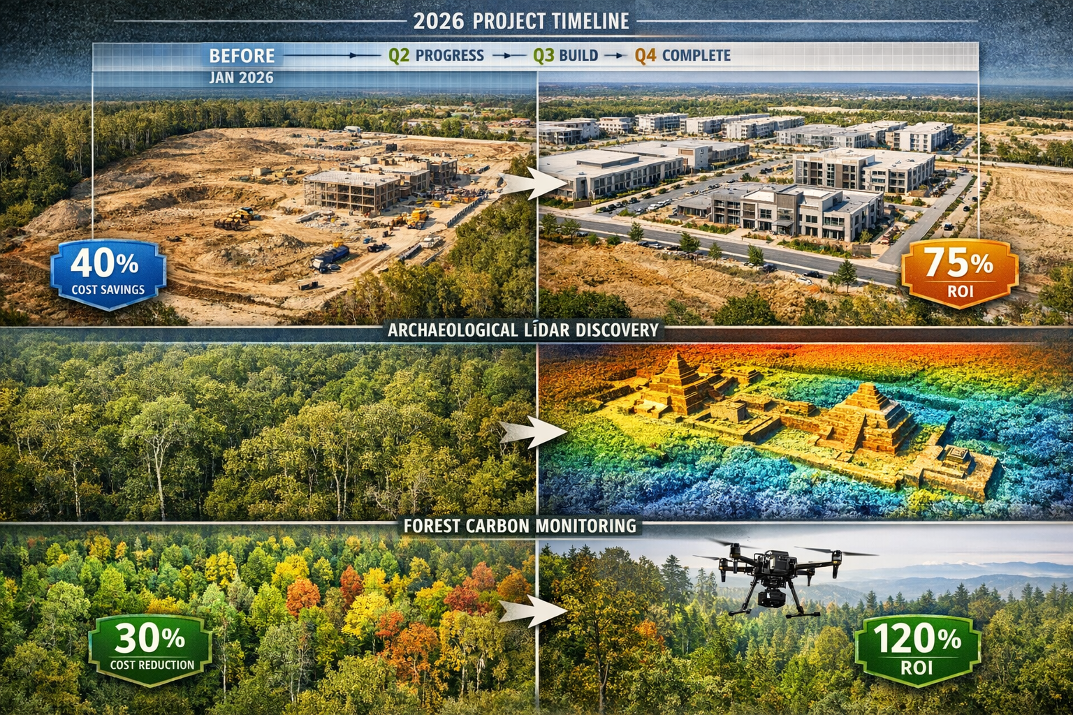
Beyond construction and development, drone technology has revolutionized archaeology by enabling discoveries that would be impossible with ground-based methods[2].
LiDAR-equipped drones can penetrate dense forest canopy to reveal terrain features hidden beneath vegetation. This capability has led to remarkable discoveries of ancient structures, settlement patterns, and cultural sites that remained undetected for centuries.
The archaeological applications demonstrate the broader principle: drone surveying excels at revealing information that traditional methods miss or cannot access. This same principle applies to construction and development projects, where comprehensive site knowledge leads to better planning and fewer surprises during execution.
Environmental and Forest Carbon Monitoring
Climate change mitigation efforts require accurate measurement of carbon storage in forests. Researchers are investigating how LiDAR drone surveys can create highly accurate estimates of carbon stored in forest sections[2].
This application showcases the precision and detail that drone surveys provide. By measuring individual tree heights, canopy density, and biomass, LiDAR data enables carbon calculations that support:
- Carbon credit verification and trading
- Forest management optimization
- Climate change research
- Environmental impact assessments
- Conservation planning
For land development projects, similar environmental analysis capabilities help satisfy regulatory requirements and support sustainable development practices. The technology complements traditional commercial building surveys by providing detailed site context and environmental data.
Artificial Intelligence and Automated Data Processing
The volume of data generated by drone surveys presents both an opportunity and a challenge. A single survey flight might capture thousands of images and millions of data points. Processing this information manually would be impractical and time-consuming.
The AI Revolution in Survey Data Analysis
Artificial intelligence is now being adopted for automated data interpretation, fundamentally changing how survey data is processed and analyzed[4]. AI systems can:
Identify Objects Automatically: Machine learning algorithms recognize and classify features in imagery and point clouds—buildings, vehicles, vegetation types, infrastructure elements, and terrain features—without human intervention.
Detect Defects and Anomalies: AI systems identify cracks in pavement, structural damage, erosion patterns, and other conditions that require attention, flagging them for human review.
Recognize Patterns: Advanced algorithms detect patterns across large datasets that might escape human observation, revealing trends, correlations, and insights.
Perform Automated Classification: Point cloud data can be automatically classified into ground points, vegetation, buildings, and other categories, saving survey personnel days of manual work[4].
Practical Benefits of AI Integration
The integration of AI into drone surveying workflows delivers several practical advantages:
Time Savings: Automated processing reduces the time from data collection to deliverable results. What might take skilled technicians days to process manually can be accomplished in hours with AI assistance.
Consistency: AI algorithms apply the same criteria uniformly across entire datasets, eliminating the variability that can occur with manual interpretation.
Scalability: Automated systems handle large datasets as easily as small ones, making frequent monitoring and large-area surveys more practical.
Enhanced Analysis: AI can identify subtle patterns and relationships that inform better decision-making, adding value beyond simple measurement and mapping.
Cost Efficiency: Reducing manual processing time lowers project costs and enables faster turnaround, improving competitiveness and client satisfaction.
The Human-AI Partnership
Despite AI's capabilities, human expertise remains essential. The most effective approach combines AI's processing power with human judgment, experience, and contextual understanding. Surveyors review AI-generated results, validate findings, and apply professional judgment to ensure deliverables meet project requirements and professional standards.
This partnership model allows professionals to focus on high-value activities—client consultation, project planning, quality assurance, and complex problem-solving—while AI handles repetitive processing tasks.
Implementing Drone Surveying: Practical Considerations for 2026
Organizations considering drone surveying adoption face several practical questions about implementation, costs, training, and integration with existing workflows.
Initial Investment and Equipment Selection
The financial commitment for drone surveying varies based on application requirements and quality expectations.
Entry-Level Systems ($2,000-$10,000): Consumer-grade drones with good cameras can produce useful results for basic applications. These systems work well for visual documentation, simple site monitoring, and preliminary assessments.
Professional Survey Systems ($15,000-$50,000): Purpose-built survey drones with high-resolution cameras, RTK GPS, and professional-grade sensors deliver the accuracy required for most construction and development applications.
Advanced LiDAR Systems ($50,000-$150,000+): Drones equipped with survey-grade LiDAR sensors represent significant investments but provide capabilities unmatched by photogrammetry alone, particularly for vegetation-covered terrain and high-precision applications.
Processing Software: Specialized photogrammetry and point cloud processing software requires additional investment, with options ranging from affordable cloud-based subscriptions to enterprise-level packages costing thousands annually.
Training and Certification Requirements
Operating drones for commercial surveying requires appropriate training and certification:
Pilot Certification: In most jurisdictions, commercial drone operations require pilot certification demonstrating knowledge of aviation regulations, airspace restrictions, and safe operating procedures.
Technical Training: Effective drone surveying requires understanding of photogrammetry principles, sensor technologies, flight planning, ground control point establishment, and data processing workflows.
Continuing Education: The technology evolves rapidly, making ongoing training essential to maintain proficiency and leverage new capabilities.
Many organizations partner with experienced drone service providers initially, gaining familiarity with the technology before making full in-house commitments. This approach reduces initial investment while building internal knowledge.
Integration with Traditional Surveying Methods
Drone surveying complements rather than replaces traditional methods. The most effective approach integrates both:
Ground Control Points: Even the most advanced drone systems benefit from surveyed ground control points that provide reference coordinates for processing and accuracy verification.
Boundary Surveys: Legal boundary determination still requires traditional surveying methods, though drones can efficiently map features within established boundaries. For property-related work, traditional boundary surveys remain essential.
Detail Verification: Ground surveys verify critical details and provide measurements in areas where drone data may be obscured or ambiguous.
Quality Assurance: Traditional survey checkpoints validate drone survey accuracy and ensure deliverables meet project specifications.
This integrated approach leverages each method's strengths while minimizing limitations, delivering optimal results for clients.
Regulatory Compliance and Airspace Management
Drone operations must comply with aviation regulations and airspace restrictions:
Flight Authorization: Operations near airports, in controlled airspace, or over certain restricted areas require advance authorization from aviation authorities.
Privacy and Permissions: Surveying private property requires appropriate permissions and consideration of privacy concerns.
Safety Protocols: Established safety procedures protect people, property, and the drone itself during operations.
Data Security: Survey data often contains sensitive information requiring appropriate security measures and confidentiality protections.
Professional drone surveying firms maintain compliance expertise and established procedures that ensure operations meet all regulatory requirements.
The Future Trajectory of Drone Surveying Technology
While drone surveying has already achieved remarkable capabilities, ongoing developments promise even greater advances in coming years.
Emerging Technologies on the Horizon
Enhanced Autonomy: Future systems will operate with even greater independence, requiring minimal human intervention for routine surveys. Drones will autonomously plan optimal flight paths, adapt to changing conditions, and make intelligent decisions about data collection priorities.
Improved Sensors: Sensor technology continues advancing rapidly. Future systems will offer higher resolution, greater accuracy, improved low-light performance, and new sensing modalities that reveal information invisible to current technology.
Extended Flight Times: Battery technology improvements and hybrid power systems will enable longer flight durations, covering larger areas per mission and reducing the need for battery changes during surveys.
Real-Time Processing: Edge computing and 5G connectivity will enable real-time data processing and visualization in the field, allowing surveyors to verify data quality and completeness before leaving the site.
Integration with BIM and Digital Twins: Tighter integration between drone survey data and Building Information Modeling (BIM) systems will create seamless workflows from site survey through design, construction, and facility management.
Standardization and Industry Maturation
The drone surveying industry is transitioning from innovation phase to established standard practices[5]. This maturation brings:
Industry Standards: Professional organizations are developing standards for accuracy, deliverable formats, quality assurance, and best practices.
Workflow Integration: Software platforms increasingly integrate drone data with traditional surveying, CAD, GIS, and project management systems.
Professional Recognition: Drone surveying is gaining recognition as a specialized professional discipline with defined competencies and qualifications.
Market Expansion: As costs decrease and capabilities improve, drone surveying becomes accessible to smaller firms and applicable to more project types.
Expanding Application Domains
New applications continue emerging as technology advances and costs decline:
Infrastructure Inspection: Detailed inspection of bridges, towers, power lines, and other infrastructure using high-resolution imagery and AI-powered defect detection.
Precision Agriculture: Multispectral and thermal imaging supporting crop health monitoring, irrigation optimization, and yield prediction.
Emergency Response: Rapid damage assessment following natural disasters, search and rescue operations, and hazard mapping.
Urban Planning: Comprehensive 3D city models supporting planning, development review, and smart city initiatives.
Environmental Monitoring: Tracking changes in coastlines, wetlands, forests, and other natural systems over time.
These expanding applications demonstrate that the revolution in land surveying extends far beyond traditional boundaries, touching virtually every field that requires spatial information.
Overcoming Challenges and Limitations
Despite remarkable capabilities, drone surveying faces certain limitations and challenges that practitioners must understand and address.
Weather Dependency
Drones operate best in favorable weather conditions. High winds, precipitation, and extreme temperatures can prevent safe operations or degrade data quality. This weather dependency requires:
- Flexible scheduling that accommodates weather delays
- Backup plans for time-sensitive projects
- Weather monitoring and forecasting capabilities
- Understanding of how conditions affect different sensor types
Regulatory Constraints
Aviation regulations impose restrictions on drone operations, including:
- Altitude limitations (typically 400 feet above ground level)
- Visual line-of-sight requirements (though waivers are increasingly available)
- Airspace restrictions near airports and sensitive areas
- Operational limitations in populated areas
Navigating these regulations requires expertise and sometimes limits where and how drones can operate.
Data Processing Requirements
While AI reduces processing time, drone surveys still generate massive datasets requiring:
- Powerful computer hardware for processing
- Specialized software and technical expertise
- Quality control procedures to ensure accuracy
- Data storage and management systems
Organizations must invest in processing infrastructure and capabilities, not just drone hardware.
Limitations in Certain Environments
Some situations challenge drone surveying:
- Dense urban environments with tall buildings and limited flight space
- Areas with heavy electromagnetic interference
- Situations requiring measurements beneath overhangs or inside structures (though GPS-denied sensors are addressing this)
- Extremely large areas where traditional aerial survey aircraft may be more efficient
Understanding these limitations helps practitioners select appropriate methods for each project.
Making the Business Case for Drone Technology Adoption
For firms considering drone surveying adoption, building a compelling business case requires analyzing costs, benefits, and strategic implications.
Quantifying the Benefits
Direct Cost Savings: Calculate labor cost reductions from faster data collection, reduced field time, and automated processing. Compare drone survey costs against traditional methods for typical projects.
Revenue Opportunities: Estimate potential revenue from new service offerings and expanded market reach enabled by drone capabilities.
Competitive Advantages: Consider the value of faster project delivery, enhanced capabilities, and differentiation from competitors still using only traditional methods.
Risk Reduction: Account for safety improvements from reducing personnel exposure to hazardous conditions and better project outcomes from comprehensive data.
Calculating Total Cost of Ownership
A complete financial analysis includes:
- Initial equipment purchase
- Software licenses and subscriptions
- Training and certification costs
- Insurance premiums
- Maintenance and replacement reserves
- Processing infrastructure investments
- Personnel time for operations and processing
Compare these costs against the savings and revenue opportunities to determine payback period and return on investment.
Strategic Considerations
Beyond immediate financial metrics, consider strategic factors:
Market Positioning: How will drone capabilities affect the firm's competitive position and market perception?
Client Expectations: Are clients increasingly expecting or requesting drone survey options?
Technology Trajectory: How will continued technology advancement affect those who adopt early versus late?
Workforce Development: What skills and capabilities will the firm need to remain competitive in coming years?
These strategic considerations often prove as important as immediate financial returns in adoption decisions.
Conclusion: Embracing the Surveying Revolution
The transformation of land surveying through drone technology represents one of the most significant advances in the profession's history. Revolutionizing Land Surveying: The Rise of Drone Technology and UAV Applications in 2026 is not merely a trend—it's a fundamental shift in how spatial data is collected, processed, and applied across construction, development, and numerous other fields.
The evidence is compelling: drone surveys deliver centimeter-level accuracy in hours rather than weeks, save tens of thousands of dollars annually, and access terrain that challenges or defeats traditional methods. Technologies like autonomous swarms, GPS-denied navigation, LiDAR sensors, and AI-powered processing continue advancing rapidly, expanding capabilities while reducing costs.
For professionals in construction, land development, engineering, and related fields, the question is no longer whether to adopt drone surveying, but how quickly and effectively to integrate it into operations. The firms achieving greatest success combine drone technology with traditional surveying expertise, creating hybrid workflows that leverage each method's strengths.
Actionable Next Steps
For Organizations Considering Adoption:
- Assess Current Needs: Identify specific projects and applications where drone surveying would provide the greatest value
- Research Options: Explore equipment options, service providers, and implementation approaches suited to your requirements and budget
- Start Small: Consider pilot projects or partnerships with drone service providers to gain experience before major investments
- Develop Expertise: Invest in training for key personnel or hire experienced drone surveying professionals
- Plan Integration: Design workflows that effectively combine drone and traditional surveying methods
For Current Practitioners:
- Stay Informed: Monitor technology developments, industry standards, and best practices through professional organizations and continuing education
- Expand Capabilities: Explore new applications and advanced technologies like LiDAR and AI-powered processing
- Share Knowledge: Contribute to industry standardization and professional development through mentoring and knowledge sharing
- Optimize Workflows: Continuously refine processes to maximize efficiency and data quality
For Project Owners and Developers:
- Specify Requirements: Include drone surveying options in project specifications where appropriate
- Evaluate Providers: Assess surveying firms' drone capabilities, experience, and quality assurance procedures
- Leverage Data: Utilize comprehensive drone survey data across project phases—planning, design, construction, and operations
- Monitor Progress: Take advantage of affordable periodic drone surveys for construction monitoring and documentation
The revolution in land surveying is well underway, driven by proven technology, demonstrated value, and expanding capabilities. Those who embrace these advances position themselves for success in an increasingly competitive and technologically sophisticated marketplace. The future of surveying has arrived—and it flies. ✈️
Whether you're planning a large-scale development project, monitoring construction progress, or seeking comprehensive site analysis, modern drone surveying offers capabilities that were unimaginable just years ago. Understanding these technologies and their applications enables better decision-making and more successful project outcomes.
For property-related surveying needs, from homebuyer surveys to commercial building surveys, integrating traditional expertise with advanced drone technology delivers optimal results. The convergence of proven professional standards with revolutionary technology creates unprecedented opportunities for accuracy, efficiency, and insight.
References
[1] How Technology Is Revolutionizing Land Surveys – https://www.firstchoicesurveying.com/blog/how-technology-is-revolutionizing-land-surveys
[2] Drone Surveying – https://uavcoach.com/drone-surveying/
[3] Advancing Surveying With Drone Technology – https://www.unmannedsystemstechnology.com/feature/advancing-surveying-with-drone-technology/
[4] Next Generation Drone Sensors And The Future Of Surveying – https://www.commercialuavnews.com/next-generation-drone-sensors-and-the-future-of-surveying
[5] With Gis Technology Drone Industry Alights In Reality – https://www.esri.com/about/newsroom/arcnews/with-gis-technology-drone-industry-alights-in-reality
[6] Watch – https://www.youtube.com/watch?v=CSTodaZb4Vc
[7] Webinar The State Of Drone Surveying A Strategic Briefing For 2026 – https://www.aerotas.com/blog/webinar-the-state-of-drone-surveying-a-strategic-briefing-for-2026
[8] The Real Cost Of Surveying How Drones Save Time And Money – https://www.traceair.net/whats-new/the-real-cost-of-surveying-how-drones-save-time-and-money