
Between 2020 and 2025, rural recreational land values in parts of the United States rose by double digits annually, driven almost entirely by a single structural shift: the mass adoption of remote work [4]. That same force is now reshaping the land surveying profession in ways that few anticipated. The impact of remote work trends on land surveying — assessing rural properties and vacation home developments — is no longer a niche conversation. It sits at the intersection of technology, migration economics, and professional practice, and understanding it is essential for property investors, developers, and chartered surveyors alike.
Key Takeaways
- Remote work has become a primary driver of demand for rural and vacation-home land surveys, pushing surveyors into more complex, less accessible terrain.
- Hybrid survey methods combining drones, AI-assisted analysis, and selective on-site fieldwork are now standard practice for large rural and resort-style projects.
- Virtual preliminary surveys support investor due diligence, but legally binding boundary and title surveys still require physical presence.
- Rural land prices near major metros have surged, creating higher-stakes survey requirements for buyers and lenders.
- Policy shifts toward digital infrastructure and flexible rural housing are expected to sustain this demand well beyond 2026.
How Remote Work Reshaped Rural Property Demand
The relationship between flexible working arrangements and property markets is now well documented. Research from the Penn Institute for Urban Research confirms that remote work is shifting real-estate demand toward less-dense, more affordable areas, reinforcing suburban, rural, and vacation-home markets that had previously been constrained by commuting distances [3]. When workers no longer need to live within 30 minutes of a city office, the calculus of where to buy land changes entirely.
This migration pattern has had a measurable effect on rural land prices. Platforms tracking recreational land transactions report that remote workers are among the most active buyers of large rural parcels — properties with hunting rights, fishing access, or simply enough space for a home office with a view [4]. In Texas Hill Country, the Ozarks, rural Oxfordshire, and similar regions, demand from remote-working buyers has compressed inventory and pushed prices upward.
"Remote work has effectively extended the commuter belt to infinity — and land surveyors are following buyers into terrain they rarely visited a decade ago."
For land surveyors, this geographic expansion creates both opportunity and operational challenge. Properties that once sat quietly on the market now attract multiple offers, each buyer requiring a formal survey before financing can be secured. The volume of rural survey commissions has grown substantially, and the complexity of those commissions — large acreages, irregular boundaries, access disputes, flood-plain overlaps — has grown with it [8].
The economic logic is straightforward. As Van Nieuwerburgh's analysis of the remote work revolution notes, the decoupling of residence from workplace has produced a structural revaluation of space: urban commercial real estate has softened while low-density residential and rural land has appreciated [7]. Surveyors who understand this dynamic are better positioned to advise clients on the full implications of a rural purchase.
The Surveying Profession's Response: Drones, Virtual Assessments, and Hybrid Methods
The impact of remote work trends on land surveying extends beyond demand volume. It has also accelerated the adoption of new survey technologies that were previously considered supplementary.
Drone and Aerial Survey Technology
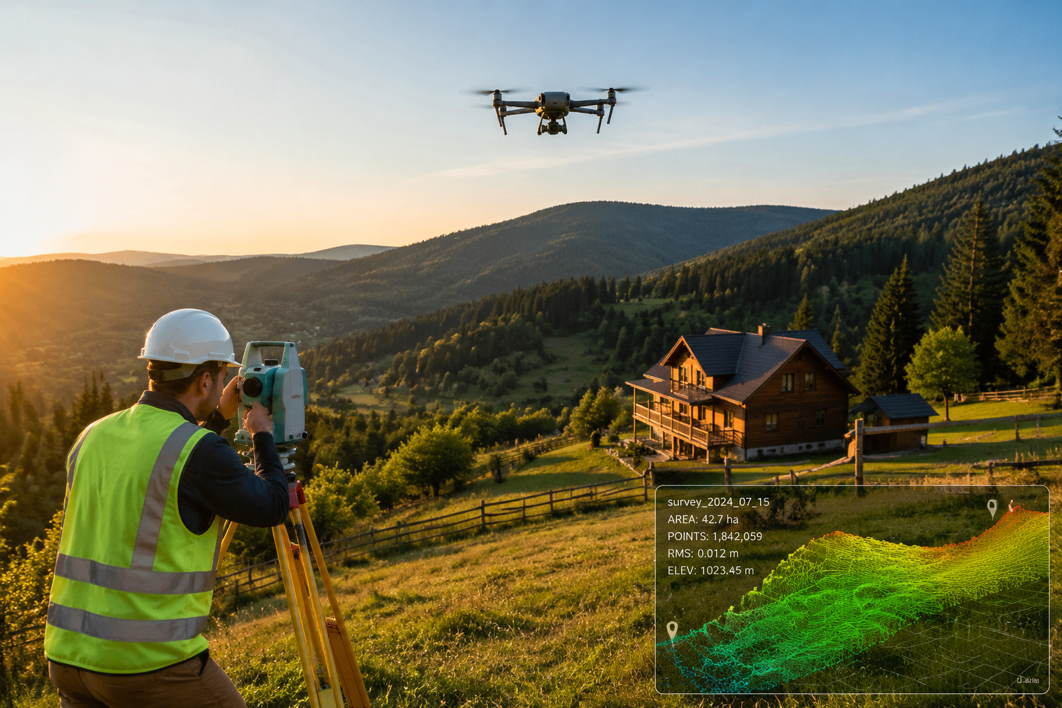
Hybrid surveying — combining unmanned aerial vehicles (drones) with selective on-site ground checks — has become the default approach for large rural and resort-style developments. A single drone flight can capture topographic data across hundreds of acres in a fraction of the time a traditional ground survey would require. The resulting point-cloud data and orthomosaic imagery can be processed using AI-assisted software to produce accurate elevation models, boundary overlays, and drainage assessments [1].
For vacation home developments in particular, this matters enormously. A developer planning 40 holiday lodges across a 200-acre woodland site needs topographic accuracy, drainage mapping, and access-route analysis before a single planning application can be submitted. Drone-led surveys deliver all three simultaneously, reducing project timelines and costs.
The key distinction, however, is legal standing. Drone surveys provide powerful preliminary data, but they do not replace the formal boundary survey conducted by a licensed professional on the ground. Mortgage lenders, local authorities, and courts require surveys with a physical inspection component. This is a critical point for investor clients who may assume that a high-resolution aerial image constitutes a complete survey [1].
Virtual Preliminary Surveys and Remote Due Diligence
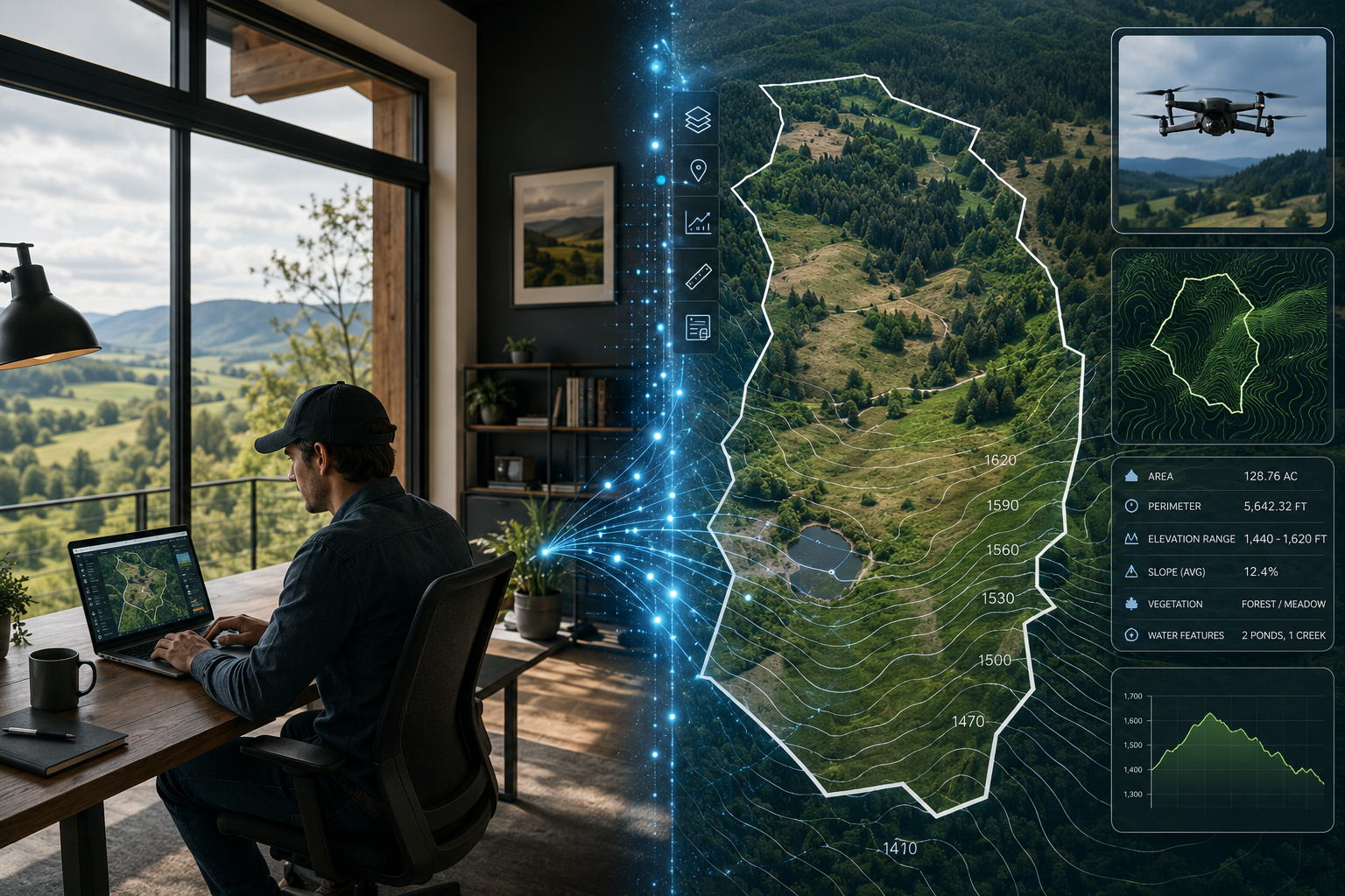
Remote and AI-assisted "virtual surveys" have expanded significantly for preliminary due diligence on rural and vacation properties. These typically involve a combination of satellite imagery, historical ordnance survey data, publicly available land registry records, and drone footage to give an investor a working picture of a site before committing to a physical inspection.
For buyers considering rural properties from a distance — a London-based remote worker eyeing a smallholding in Buckinghamshire, for instance — this virtual layer of due diligence has genuine value. It can identify obvious red flags: encroachments, access issues, watercourse boundaries, or planning restrictions that would make a site unsuitable before any travel or expense is incurred.
That said, the limitations are real. Virtual surveys cannot detect subsurface drainage problems, structural issues with existing buildings, or subtle boundary discrepancies that only become visible on the ground. For any transaction involving mortgage finance or legal title transfer, a full physical survey by a qualified chartered surveyor remains non-negotiable. Buyers considering a rural property purchase should review what a Level 2 house survey covers and whether a more detailed assessment is warranted given the property's condition and complexity.
Comparing Survey Approaches for Rural Properties
| Survey Method | Best Use Case | Legal Standing | Cost Level |
|---|---|---|---|
| Drone/Aerial Survey | Large acreage, topographic mapping | Preliminary only | Moderate |
| Virtual/Remote Due Diligence | Initial investor screening | None (advisory) | Low |
| Level 2 (Homebuyer) Survey | Standard rural residential | Full | Moderate |
| Level 3 (Building) Survey | Older/complex rural buildings | Full | Higher |
| Full Boundary/Title Survey | Disputed boundaries, development | Full | Higher |
For buyers uncertain about which survey level suits a rural or vacation property, comparing different types of survey is a useful starting point before engaging a surveyor.
Rural Land Investing in 2026: Surveying Implications
As of 2026, rural land investing is explicitly framed around three converging themes: remote work lifestyle migration, sustainability, and long-term capital appreciation [6]. This framing has direct consequences for the surveying profession.
Larger Parcels, More Complex Assessments
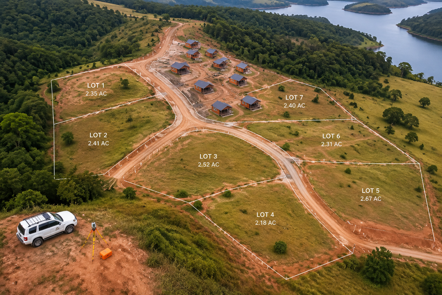
The typical rural land transaction has grown in scale. Where a decade ago a buyer might purchase a single residential plot, today's remote-work-motivated buyer is more likely to be acquiring five to fifty acres — enough for a primary residence, a separate home office structure, potential holiday-let units, and some agricultural or woodland amenity. Each of these elements carries its own survey requirement.
A parcel with existing buildings requires a structural condition assessment. Woodland or agricultural land may need a topographic survey to understand drainage and access. Any development of new structures will require boundary confirmation and potentially a party wall assessment if the site adjoins neighbouring land. For buyers navigating these layers, understanding topographic survey costs upfront helps set realistic budgets.
Planning Policy and Digital Infrastructure
Policy research from Nordregio highlights that planning authorities across Europe and North America are actively designing frameworks to support digital infrastructure, diverse housing types, and flexible rural co-working spaces [2]. These policy shifts — fibre broadband rollouts, permitted development reforms for rural conversions, and relaxed planning rules for agricultural-to-residential change of use — are generating a secondary wave of surveying demand.
When a barn conversion becomes permissible under new planning rules, the landowner needs a survey. When a rural co-working hub is proposed on agricultural land, a topographic and boundary survey precedes the planning application. Policy-driven development and market-driven demand are, in this context, mutually reinforcing.
Key surveying triggers in rural development contexts:
- Boundary confirmation before purchase or subdivision
- Topographic surveys for drainage and access planning
- Structural surveys of existing farm buildings earmarked for conversion
- Party wall assessments where new structures adjoin existing boundaries
- Reinstatement cost valuations for insurance purposes on remote properties
For investors purchasing rural properties with existing structures, understanding whether a Level 3 building survey is appropriate — given the age and complexity of rural farm buildings — can prevent costly surprises post-completion.
Vacation Home Developments: A Distinct Survey Challenge
Vacation home developments present a specific set of surveying challenges that differ from standard residential transactions. These sites are typically larger, often located in areas with complex topography, and subject to planning conditions that restrict development density or require ecological assessments alongside survey work.
Remote work has intensified demand for short-term holiday lets as well as permanent rural relocation [9]. Investors developing holiday lodge parks or glamping sites need surveys that address not only boundary and title questions but also drainage gradients, flood risk zones, and access road suitability. The interaction between these technical requirements and the legal framework governing development makes professional surveying advice indispensable.
For buyers considering whether a survey is genuinely necessary before committing to a rural or vacation property purchase, the answer is almost always yes — and the reasoning is explored in detail in this guide on whether you need a home survey when buying a property.
Practical Guidance for Buyers, Investors, and Developers
The impact of remote work trends on land surveying — assessing rural properties and vacation home developments — creates a clear set of practical considerations for anyone active in this market.
For individual buyers relocating from urban areas:
- Commission a full structural survey on any existing buildings, not just a mortgage valuation. Rural properties often have non-standard construction, older drainage systems, and access arrangements that require professional scrutiny.
- Request a boundary survey if the property has large grounds or any history of disputed access. Boundary disputes in rural areas can be protracted and expensive.
- Use virtual due diligence tools to screen properties before travelling, but treat them as a starting point rather than a substitute for physical inspection.
For investors and developers:
- Budget for topographic surveys as a standard pre-acquisition cost on any parcel above two acres.
- Engage a chartered surveyor early in the planning process, not after planning permission has been sought. Survey data informs planning applications and reduces the risk of refusal.
- Understand the difference between survey types. A Level 2 versus Level 3 survey distinction matters significantly when assessing older rural buildings with potential structural issues.
For surveyors adapting to rural demand:
- Invest in drone survey capability or establish referral relationships with specialist aerial survey firms.
- Develop familiarity with rural planning policy, particularly around agricultural conversions and permitted development rights.
- Be prepared to advise clients on the limitations of virtual surveys and the legal requirements that mandate physical inspection.
The broader point is that the remote work revolution has not simply increased the number of rural survey commissions — it has changed the nature of those commissions. Buyers are more geographically dispersed, properties are more complex, and the stakes are higher because rural land prices have risen sharply. Professional surveyors who combine traditional fieldwork expertise with modern technology are best placed to serve this evolving market [10].
Conclusion
The impact of remote work trends on land surveying — assessing rural properties and vacation home developments — represents one of the most significant structural shifts the profession has experienced in decades. Demand for rural surveys has grown in volume and complexity, driven by a sustained migration of remote workers toward lower-density, higher-amenity locations. Technology has responded: drone surveys, AI-assisted data processing, and virtual due-diligence tools are now standard components of the rural surveyor's toolkit.
Yet the fundamentals have not changed. Legal title, boundary certainty, and structural condition can only be confirmed through qualified, on-site professional assessment. The technology enhances efficiency; it does not replace expertise.
Actionable next steps for 2026:
- If purchasing a rural or vacation property, engage a chartered surveyor before exchanging contracts — not after.
- Request a topographic survey on any site where development, drainage, or access is a consideration.
- Use virtual survey tools and drone data for initial screening, but treat them as preliminary intelligence rather than final assessments.
- Review the full range of survey types available and match the survey level to the property's age, complexity, and intended use.
- Stay informed about rural planning policy changes, which are generating new categories of survey demand across the UK and beyond.
The convergence of remote work culture, rural land investment, and surveying technology is not a temporary trend. It is a structural realignment of where people live, work, and invest — and land surveyors are at the centre of it.
References
[1] Remote Vs In Person Land Surveyor – https://surveyslate.com/blog/remote-vs-in-person-land-surveyor/
[2] Implications For Policymaking And Planning – https://pub.nordregio.org/r-2024-24-planning-around-remote-work/implications-for-policymaking-and-planning.html
[3] Policy Brief How Remote Work Is Affecting Real Estate Markets – https://penniur.upenn.edu/publications/policy-brief-how-remote-work-is-affecting-real-estate-markets
[4] Why Remote Workers Are Driving Up Demand For Recreational Land – https://www.landthink.com/why-remote-workers-are-driving-up-demand-for-recreational-land/
[5] The Impact Of Remote Work On Real Estate Embracing The Shift Of Urban Suburban And Rural Living – https://pinnaclerealestateacademy.com/the-impact-of-remote-work-on-real-estate-embracing-the-shift-of-urban-suburban-and-rural-living
[6] Blog Rural Land Investing 2026 – https://www.thelandgeek.com/blog-rural-land-investing-2026/
[7] The Remote Work Revolution: Impact on Real Estate Values and the Urban Environment – https://www.volckeralliance.org/sites/default/files/2023-01/Real%20Estate%20Economics%20-%202022%20-%20Van%20Nieuwerburgh%20-%20The%20remote%20work%20revolution%20%20Impact%20on%20real%20estate%20values%20and%20the%20urban.pdf
[8] The Remote Revolution How Work From Home Is Redefining Rural Real Estate – https://www.ucrealestateandauction.com/articles/real-estate/-the-remote-revolution–how-work-from-home-is-redefining-rural-real-estate
[9] Remote Work Real Estate – https://www.minut.com/blog/remote-work-real-estate
[10] Remote Workers Land Demand Recreational Land Rural Land Investment – https://www.preferredpropertiestx.com/2025/08/remoteworkers-landdemand-recreationalland-texaslandforsale-rurallandinvestment-workfromhome-texashillcountry-realestate-acreageforsale-countryliving-ranchproperty-buylandintexas-huntingland-preferredp/